
The gauge of a firearm is a unit of measurement used to express the inner diameter of the barrel.
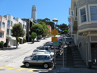
Filbert Street in San Francisco, California starts at Lyon Street on the east edge of The Presidio and runs east, crossing Van Ness Avenue and Columbus Avenue. It ends on Telegraph Hill at Kearny Street below Coit Tower and eventually resumes as a pedestrian stairway known as the Filbert Street Steps.
Green Lake Provincial Park is a provincial park in British Columbia, Canada located around Green Lake in the South Cariboo-Interlakes district just east of 70 Mile House.

Tjeldbergodden is an industrial facility mainly featuring petroleum facilities located in the northeastern part of the municipality of Aure in Møre og Romsdal county, Norway. It was constructed during the 1990s and among other things features the Statoil natural gas processing plant for the Heidrun gas field, with the gas transported to the facility by the Haltenpipe. Some of the natural gas is used at the co-located methanol plant.
Tjeldbergodden Reserve Power Station is a natural gas-fired thermal power plant located at the industrial site Tjeldbergodden in the northeastern part of the municipality of Aure in Møre og Romsdal county, Norway. It is operated by Statnett. The station has installed one gas turbine with 150 megawatts (200,000 hp) effect. The power station was installed in 2006, but by 2015 it had not been in use. Together with the similar power plant at Nyhamna, they cost 2.1 billion NOK. A new power line has made them unnecessary.
WPNE is a radio station licensed to Green Bay, Wisconsin. The station is part of Wisconsin Public Radio (WPR), and airs WPR's "NPR News and Classical Network", consisting of classical music and news and talk programming. WPNE-FM also broadcasts regional news and programming from studios in the Instructional Services building at the University of Wisconsin–Green Bay, along with sister Ideas Network station WHID (88.1).

Bordet railway station is a railway station in Brussels, Belgium. It is located on the line 26 between the stations of Haren and Evere. The station is located in the municipality of Evere, next to the border with the City of Brussels, at the crossroad between the Chaussée de Haecht/Haachtsesteenweg and the Avenue Jules Bordet/Jules Bordetlaan.
Ravna (Maglaj) is a village in the municipality of Maglaj, Bosnia and Herzegovina.
Kamaran District is a district of the Al Hudaydah Governorate, Yemen. As of 2003, the district had a population of 2,465 inhabitants.
Zeoke is a village situated in Lazarevac municipality in Serbia. It is considered a part of the Belgrade-Metropolitan area.
Orašac is a village situated in Obrenovac municipality in Serbia.
Shankharibazar massacre was a massacre of the Hindus of the Shankharibazar area of Old Dhaka on 26 March 1971 by the Pakistani occupation army. The survivors fled to the villages on the other side of the Buriganga, in the region now known as Keraniganj. Shankharibazar became deserted and dead bodies remained on the streets for quite a long time. The Pakistani establishment renamed the Shankharibazar Road to Tikka Khan Road.
Djrègbè is an arrondissement in the Ouémé department of Benin. It is an administrative division under the jurisdiction of the commune of Sèmè-Kpodji. According to the population census conducted by the Institut National de la Statistique Benin on February 15, 2002, the arrondissement had a total population of 10,527.
Tohouè is an arrondissement in the Ouémé department of Benin. It is an administrative division under the jurisdiction of the commune of Sèmè-Kpodji. According to the population census conducted by the Institut National de la Statistique Benin on February 15, 2002, the arrondissement had a total population of 17,652.
Daping is a town under the jurisdiction of Xingning City, Meizhou, in eastern Guangdong Province, China.
Silver Creek Township is a township in Mills County, Iowa, USA.
Vesta Township is a township in Walsh County, North Dakota.
Veobreen is a glacier in Oppland, Norway. It covers an area of about nine square kilometers, and is locataed within the Jotunheimen National Park, in the municipalities of Lom and Vågå.
The Kamchiq Tunnel is a 19.2 kilometres (11.9 mi) long railway tunnel in Uzbekistan, which makes it the longest tunnel in Central Asia and in ex-USSR, and the longest broad gauge railway tunnel in the world.
Aller Park was a village in Devon, England. It was situated near Newton Abbot.


