
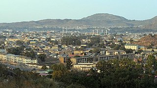
Port Harcourt is the capital and largest city of Rivers State in Nigeria. It is the fifth most populous city in Nigeria after Lagos, Kano, Ibadan and Benin. It lies along the Bonny River and is located in the oil rich Niger Delta region. As of 2023, Port Harcourt's urban population is estimated at 3,480,000. The population of the metropolitan area of Port Harcourt is almost twice its urban area population with a 2015 United Nations estimate of 2,344,000. In 1950, the population of Port Harcourt was 59,752. Port Harcourt has grown by 150,844 since 2015, which represents a 4.99% annual change.

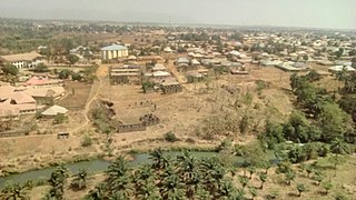
Aba is a city in southeastern Nigeria and the commercial centre of Abia State. Upon the creation of Abia State in 1991, the old Aba township was divided into two local government areas, being Aba South and Aba North, while the suburban neighborhood of what was then known as Obioma Ngwa L.G.A. was divided into three L.G.A.s for administrative convenience. Aba South is the main city centre of Aba and Abia State at large, being located on the Aba River. Aba is made up of many villages such as Aba-Ukwu, Eziukwu-Aba, Obuda-Aba, Umuokpoji-Aba and other villages that have been merged for administrative convenience. Aba was established by the Ngwa clan of the Igbo people in Nigeria as a market town. Later, a military post was placed there by the British colonial administration in 1901. It lies along the west bank of the Aba River and is at the intersection of roads leading to Port Harcourt, Owerri, Umuahia, Ikot Ekpene, and Ikot-Abasi. The city became a collection point for agricultural products following construction of a British-made railway running through it to Port Harcourt. Aba is a major urban settlement and commercial centre in its region, which is surrounded by small villages and towns. The indigenous people of Aba are the Ngwa. Aba is well known for its craftsmen and is the most populous city in southeastern Nigeria. As of 2016, Aba had an estimated population of 2,534,265, making it the biggest city in South Eastern Nigeria.
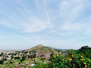
Jos is a city in the North-Central region of Nigeria. The city has a population of about 900,000 residents based on the 2006 census. Popularly called "J-Town", it is the administrative capital and largest city of Plateau State. The city is situated on the Jos plateau which is embedded in the Guinea Savannah of North-Central Nigeria. It connects most of the North-Eastern capitals to the Federal Capital Territory Abuja, by road. Driving in and out of Jos, traffic encounters very steep sloppy bends and breathtaking mountainous sceneries typical of the plateau landform. The name of the state was coined from its affiliation to this landform.
Plateau State is a north central Nigerian state. It is located near the centre of Nigeria and includes a range of hills surrounding the Jos Plateau. Plateau State is described as "The Home of Peace and Tourism". The state has a population of around 4.7 million people. Its capital city is Jos.

Bauchi is a city in northeast Nigeria, the Administrative center of Bauchi State, of the Bauchi Local Government Area within that State, and of the traditional Bauchi Emirate. It is located on the northern edge of the Jos Plateau, at an elevation of 616 m. The Local Government Area covers an area of 3,687 km2 and had a population of 493,810 in 2006.

Enugu State is a state in the South-East geopolitical zone of Nigeria, bordered to the north by the states of Benue and Kogi, Ebonyi State to the east and southeast, Abia State to the south, and Anambra State to the west. The state takes its name from its capital and largest city, Enugu. The city acquired township status in 1917 and was called Enugwu-Ngwo. Due to the rapid expansion towards areas owned by other indigenous communities, it was renamed Enugu in 1928.

The Eastern Region was an administrative region in Nigeria, dating back originally from the division of the colony Southern Nigeria in 1954. Its first capital was Calabar. The capital was later moved to Enugu and the second capital was Umuahia. The region was officially divided in 1967 into three new states, the East-Central State, Rivers State and South-Eastern State. East-Central State had its capital at Enugu, which is now part of Enugu State.

The Jos Plateau is a plateau located near the centre of Nigeria. The plateau has given its name to the Plateau State in which it is found and is named for the state's capital, Jos. The plateau is home to people of diverse cultures and languages. The plateau's montane grasslands, savannas, and forests are home to communities of plants and animals distinct from those of the surrounding lowlands and constitute the Jos Plateau forest-savanna mosaic ecoregion.
Theological College of Northern Nigeria (TCNN) is a private, Christian college located in Bukuru, Plateau State, Nigeria.

Nigerian Railway Corporation is the state-owned enterprise with exclusive rights to operate railways in Nigeria.
The Berom is one of the largest autochthonous ethnic group in Plateau State, central Nigeria. Covering about four local government areas, which include Riyom, Jos North, Jos South and Barkin Ladi (Gwol). Berom people are also found in some southern Kaduna State local government areas like Fadan Karshe with Berom settlers tracing their origins to Za'ang a Berom district on the Jos Plateau. They emigrated during the British Colonial Government of Nigeria. A large number of this tribe, if not all, are Christians. Statistics also have it that a large number of the population of Plateau State is made up of Berom people.
Kafanchan is a town located in the southern part of Kaduna State, Nigeria. The town owes much of its development to the railway development in the area. The railway is situated at a particular junction of the Nigerian Railway Corporation (NRC) station built in 1927. It sits on the railtrack connecting Port Harcourt, Enugu, Kafanchan, Kuru, Bauchi and finally Maiduguri. As of 2007, Kafanchan had an estimated population of 83,092.
Railways in Nigeria consist of a 3,505 km Cape gauge national railway network and 669 km of standard gauge. The Cape gauge network is in poor condition due to lack of maintenance. In 2019, the single operational standard gauge line from Abuja to Kaduna generated as much revenue as the entire Cape gauge railway network combined. The Nigerian government plans to extend the standard gauge to replace most of the Western Line, while the Eastern Line will be rehabilitated as a Cape gauge line. All trains in Nigeria are operated by the Nigerian Railway Corporation.
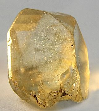
The mining of minerals in Nigeria accounts for only 0.3% of its gross domestic product, due to the influence of its vast oil resources. The domestic mining industry is underdeveloped, leading to Nigeria having to import minerals that it could produce domestically, such as salt or iron ore. The rights to ownership of mineral resources is held by the Federal Government of Nigeria, which grants titles to organizations to explore, mine, and sell mineral resources. Organized mining began in 1903, when the Mineral Survey of the Northern Protectorates was created by the British colonial government. A year later, the Mineral Survey of the Southern Protectorates was founded. By the 1940s, Nigeria was a major producer of tin, columbite, and coal. The discovery of oil in 1956 hurt the mineral extraction industries, as government and industry both began to focus on this new resource. The Nigerian Civil War in the late 1960s led many expatriate mining experts to leave the country. Mining regulation is handled by the Ministry of Solid Minerals Development, who are tasked with the responsibility of overseeing the management of all mineral resources in Nigeria. Mining law is codified in the Federal Minerals and Mining Act of 1999. Historically, Nigeria's mining industry was monopolized by state-owned public corporations. This led to a decline in productivity in almost all mineral industries. The Obasanjo administration began a process of selling off government-owned corporations to private investors in 1999. The Nigerian Mining Industry has picked up since the "Economic Diversification Agenda", from Oil & Gas, to Agriculture, Mining, etc., began in the country.

Railway stations in Nigeria include:
Neptune Bank Power Station was a coal-fired power station situated on the River Tyne at Wallsend near Newcastle upon Tyne. Commissioned in 1901 by the Newcastle upon Tyne Electric Supply Company, the station was the first in the world to provide electricity for purposes other than domestic and street lighting. It was also the first in the world to generate electricity using three-phase electrical power distribution at a voltage of 5,500 volts.
Joseph Karakitie Azigbo (1918–1986) was a Nigerian business magnate and notable figure within the Okpe Kingdom of Nigeria. In the early 1950s, Azigbo achieved substantial success as an industrial entrepreneur-a position that made him attain a level of affluence within Nigeria. However, his life was marked by the Nigerian Civil War, during which a considerable portion of his assets were either confiscated or damaged by the Nigerian army.
The Bauchi Light Railway was a 2 ft 6 in narrow gauge railway built in 1914 to carry tin from Jos in Nigeria to the main line 3 ft 6 in railway at Zaria.
Jos North is a local government area in Plateau State, Nigeria. Its headquarters are in the city center of Jos.The postal code of the area is 930.
Jos South is a Local Government Area in Plateau State, Nigeria. It houses the Plateau State new Government house which includes the Office of the Executive Governor and other government house administrative offices and departments including Plateau State Information and Communication Technology Development Agency in Rayfield and can thus be described as the de facto capital of Plateau state. Its headquarters is located in Bukuru town on 9°48′00″N8°52′00″E.
