The park is named after the Burfoot family who once owned the land.[1] The park is under management of the Thurston County Parks department.[2].
An artificial reef made of tires that was located off the shores of Burfoot Park was begun to be removed in 2025. Containing approximately 17,000 tires, the attempted reef was part of an overall effort within the Puget Sound during the 1970s and 1980s to increase aquatic wildlife in the waters as a means to strengthen recreational fishing. The tires spread after polypropylene twine holding the tire bundles in place dissolved, becoming a damaging, negative environmental impact.[3]
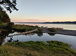
Geography
The forested site is located on a peninsula overlooking Budd Inlet, north of Olympia.[1] Burfoot Park covers 65 acres (260,000m2) of property with 1,100 feet (340m) of saltwater beach frontage on the Puget Sound waterway.[2][4]
Features
The recreation area features picnic shelters, a small playground, and public restrooms.[5]
This page is based on this Wikipedia article Text is available under the CC BY-SA 4.0 license; additional terms may apply. Images, videos and audio are available under their respective licenses.