Parks and recreation in Olympia, Washington, which includes recreational sites and trails, is overseen by the Olympia Parks, Arts & Recreation Department. Additional parks and trails within or near the city are managed under Thurston County oversight or by various Washington state agencies.
The first official public use site in the city began in 1850 and became known as Sylvester Park. Continued growth, especially in the 21st century, has allowed the city of Olympia, as of 2025[update], to amass a collection of 45 parks encompassing more than 1,400 acres (570ha).
History and management
Parks and recreation areas in the city of Olympia is overseen by the Olympia Parks, Arts & Recreation Department (OPARD).[1][2] The first official park began as a land donation to the city, eventually becoming Sylvester Park, with a further purchase of a land claim in 1906 for Priest Point Park.[3][4]
By 2001, the city was reported to have 21 parks encompassing 738 acres (299ha).[3] During a two-year period ending in 2007, the department spent $9.8million to acquire an additional 49 acres (20ha) split between eight park sites; the funds were provided by a temporary 3% utility tax.[5] Several acquisitions increased the total land holdings to 1,465 acres (593ha) in 2021.[6] The city's public works department transferred four parcels to OPARD in September 2021. The ceded properties included Black Lake Meadows, the Taylor Wetlands, and the stormwater collection areas of Indian Creek and Yauger Park. Part of the transfer also included the Kaiser Wood, LBA Woods, and West Bay Woods open space reserves.[6]
As of 2025[update], the agency manages 45 parks, provides educational classes and programs, and collaborates with artists and communities to install public artworks in the city.[1] The city contains 24 miles of trails, a dozen athletic fields and 25 sports courts, and twelve playgrounds. Over 130 community gardens and individual public artworks are extent in Olympia.[2]:12
List of parks in Olympia, Washington
Unless otherwise noted, information about the following Olympia parks, such as acreage, addresses, and establishment dates, is provided by the Olympia Parks, Arts & Recreation Department.[7][a]
Neighborhood parks
Olympia classifies small parks, usually containing playground areas and open spaces, as neighborhood parks. The recreation sites can contain additional amenities such as picnic areas and public art, or other recreational opportunities such as athletic courts and trails.[2]:31,32
Name
Image
Established
Location
Size
Description
8th Avenue Neighborhood Park
2007
3102 8th Avenue NE
4.0 acres (1.6ha)
Purchased by the city for $580,000, the grounds were originally the site of a horse stable.[5]
Bigelow Park
1943
1220 Bigelow Ave NE
1.9 acres (0.77ha)
Picnic, playground, and recreation park named after an early settler family in Olympia.[8] The grounds contain a public artwork space known as the Stone Amphitheater.[9]
Burri Park
2007
2415 Burbank Ave NW
2.32 acres (0.94ha)
Neighborhood park featuring a small trail and recreation and playground areas. The site was named after a Jim Burri, long-serving supporter of parks in Olympia.[10]
Decatur Woods Park
2004
1015 Decatur St SW
6.27 acres (2.54ha)
Once an apple orchard, the neighborhood site includes playgrounds, picnic amenities, and public art. A looped trail courses through a stand of Douglas fir. Developed into a park after the plot was first acquired from the school district in 1989[b] in exchange for a parcel used to expand Garfield Elementary.[12][13][14]
Evergreen Park
2007
1445 Evergreen Park Dr SW
4.0 acres (1.6ha)
Purchased by the city for $74,000, the park is located near the Thurston County Courthouse.[5]
Harry Fain's Legion Park
1987
1115 20th Ave SE
1.3 acres (0.53ha)
Across from Watershed Park, features include a playground and nature trails in a wooded area. Gifted by its namesake to the city in 1933.[15] Fain was a known womanizer who was killed by his wife in 1937. The park honors his days as a World War Isubmariner.[16]
Kettle View Park
2011
1250 Eagle Bend Dr SE
4.8 acres (1.9ha)
Named after glacial kettles that surround the area, features in the park include a large open space, playground, tennis court, and a short loop trail.[17] The site was originally known as Henderson Road Park, a joint city and subdivision recreation area purchase in 2007.[5]
Lions Park
1946
800 Wilson St SE
3.72 acres (1.51ha)
Begun by a combined effort of Olympia's Eastside neighborhood and a local Lions Club, park features include basketball, horseshoe, and tennis courts, picnic and playground areas, and a spray park.[18][19]
Margaret McKenny Park
2009
3111 21st Ave SE
4.16 acres (1.68ha)
Site was purchased by the city in 1999 and dedicated ten years later to Margaret McKenny, a published naturalist. McKenny was a founder of Citizens for the Future, a local group that helped to save Watershed Park. Features include a basketball court, looped trail, and a playground.[20][21]
McGrath Woods Park
2009
2300 Cain Rd SE
4.0 acres (1.6ha)
Located in Southeast Olympia, the park contains an open meadow and a looped trail.[22]
Sunrise Park
1995
505 Bing St NW
5.74 acres (2.32ha)
First community garden within an Olympia Park,[23] the site contains a sledding hill as well as playgrounds and a basketball court. The park began under a joint cooperation of the local community and a neighborhood association in 1991. Dedicated in 1995.[24]
Named after Sam Woodruff, early Olympian developer, who sold the land to the city for $1 in 1892. Features several athletic courts, a playground, picnic shelters, and a sprayground, the first such in the city.[25][19]
Additional neighborhood parks, which may be undeveloped, include the 18th Avenue and Lilly Road parcels and Olympia Park.[2]:32
Community parks
Community parks in the city are considered to serve as larger recreational venues for a wider range of activities as well as increased numbers of the local population. Sites usually include athletic courts and fields, but can also be associated with community gardens or waterfront areas.[2]:31,32
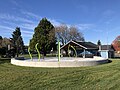
Also known as East Bay Public Plaza, it was officially opened in 2012. Situated in front of the Hands On Children's Museum, the park contains a reclaimed waterway, public art, play areas, and picnic amenities with waterfront views of Budd Inlet and the Olympic Mountains.[27][28]
Isthmus Park
2018
529 4th Ave W
2.34 acres (0.95ha)
Once the site of county government buildings, the structures were razed in 2015. Park contains "Oly on Ice", the city's ice skating rink, and a pump track.[29][30][31]
Madison Scenic Park
1989
1600 10th Ave SE
2.21 acres (0.89ha)
Hillside residential park created in partnership with the Eastside Neighborhood Association and the city. Picnic and walking path grounds that overlook the city.[32][23] The city acquired the park from the school district by 2007.[5]
Park of the Seven Oars
1993, 2001
Olympic Way
0.90 acres (0.36ha)
A pocket park featuring several artworks created by local artists, including a sculpture of 15 foot (4.6m)-tall oars.[33] The connection of the lives of indigenous people, the city's maritime history, and early settlers in the area are symbolized in the artworks, which includes specifically designed benches and mosaics. Originally a smaller park built in 1993, it was relocated 700 feet (213.4m) in 2001 due to an infrastructure repair project in the aftermath of the 2001 Nisqually earthquake. The park oversees Budd Inlet, the Capitol campus, and the Olympia downtown core. Features a plaza and elements from the city's original Fourth Avenue Bridge.[34][35][36]
The park is named after a commercial steamship wharf first constructed by Sam Percival in 1860.[37] Completed in three phases between 1978 and 1988, the park is located in Downtown Olympia. Percival Landing features a 0.9-mile (1.4km) boardwalk paralleling the Budd Bay shoreline. Noted for its public art displays,[38] the park contains several picnic and play areas, and the Harbor House, a city-owned building that can be rented for various uses.[39] The annual Olympia Harbor Days festival is centered around the landing; the site is home to the historic Sand Man tugboat.[37]
Rebecca Howard Park
2021
911 Adams St SE
0.34 acres (0.14ha)
An in-development downtown park named after Rebecca G. Howard, an African-American businesswoman and community leader who owned a popular and respected hotel in Olympia during the mid-19th century. The parcel, located behind the Olympia Timberland Regional Library, was purchased by the city in 2018 and contains a remodeled "eco-building" home originally constructed in 1931.[40][41][42]
Created by the Olympia-Yashiro Sister City Association, the Japanese-styled garden features public art, an 18 foot (5.5m)-tall granite pagoda, a sculpted garden and landscape with koi pond, and symbolic features between the two cities. The town of Yashiro donated several items, including stone lanterns and cedar entrance gates constructed without the use of nails. The gardens were part of a land sale to the Squaxin Indian Tribe in 2025; the site is planned to be razed for future development necessitating a relocation.[43][44]
Heritage Park is also listed under the classification.[2]:32
Open space parks
Open spaces in Olympia are usually bereft of improvements or amenities such as athletic fields or playgrounds. The habitats, outside of bathrooms, parking, or trails, are often left in their natural state. Such spaces may include a variety of aquatic ecosystems, such as creeks, marine shorelines, rivers, or wetlands, as well as forest or prairie habitats.[2]:31,32
Contains a butterfly and hummingbird garden and a natural artesian well on grounds once a homestead of the Daniel Bigelow family. Picnic area is an open space on a steep hillside, which is known as "The Place" for snow sledding.[45][46][47]
Cooper Crest Park
2003
3600 20th Ave NW
13.37 acres (5.41ha)
Also known as Cooper Crest Open Space, features a 0.25-mile (0.40km) path accessed by two separate trailheads. The grounds are part of a larger aquifer recharge zone in the area.[48][49]
Kaiser Woods
2025
4300 Park Dr SE
70.19 acres (28.40ha)
Forested site purchased by the city in 2015 along with an additional parcel in 2020. Remained undeveloped until 2025. First park in Olympia with intentional mountain biking trails. Includes approximately 5 miles (8.0km) of hiking paths.[50][51]
Springwood Drive Parcel
2015
1500 Springwood Ave NE
3.19 acres (1.29ha)
Park was originally formed in the 1960s as a rhododendron garden maintained by the Zabel family. Purchased as a preserved site by a local foundation in 2007, the grounds were donated to the city in 2015.[52][53]
Trillium Park
late 1980s
900 Governor Stevens Avenue SE; 901 Eskridge Blvd SE
4.53 acres (1.83ha)
A wetland pond, home to Chorus frogs, borders the park. Steep trails connect two residential communities. The ravine and open space area was donated as a preserve by landowners in the late 1980s.[54][55]
Part of the Moxlie Creek Springs Basin which was once the main water source of the city. The moderate to steep 1.5-mile (2.4km) G. Eldon Marshall trail loops around the park and wetland area.[56] The site was created as a park after it was saved in the 1950s by the local community group, Citizens for the Future.[21]
West Bay Woods
2016, 2017
1200 Hays Ave NW; 1415 West Bay Dr NW
18.5 acres (7.5ha)
Began as a local conservation effort in 2014, the two-parcel site was purchased by Olympia resident Alicia Elliot that same year. The city bought the sites between 2016 and 2017. The rookery preserve surrounds Olympia's only great blue heron colony.[57][58][59] A nature trail in the park connects neighborhoods in West Olympia and to West Bay Park.[60] In 2020, the preserve expanded after an 7-acre (2.8ha) parcel was acquired by the Bowen Foundation and the Olympia Coalition for Ecosystems Preservation.[61]
Additional open space parks and trails, which may be undeveloped, include the Garfield Nature Trail, the Karen Fraser Woodland Trail, the South Capitol Lots, and the Wildwood Glen and Yew Avenue parcels.[2]:32
Multi-classified parks
The list below includes parks that are classified under a combination of community, neighborhood, or open space areas and parks.[2]:31,32
Name
Image
Established
Location
Size
Description
Chambers Lake Trailhead Park
2008
4808 Herman Road
46.2 acres (18.7ha)
Park contains a forested wetland area. Closed as of 2025[update].[62][63]
Friendly Grove Park
2002
2316 Friendly Grove Road NE
14.48 acres (5.86ha)
The grounds were originally part of an 1853 land claim and once owned by Daniel Bigelow. A baseball field was built in 1958. The parcel was purchased by the city in 1997 and opened as a neighborhood park in 2002 after a $1.2million effort. Features include various fields and courts for sports activities including a beginner-to-intermediate skatepark, as well as picnic areas and a walking path.[64]
LBA Park and Woods
1974
3333 Morse-Merryman Rd SE
155.5 acres (62.9ha)
Short for Little Baseball Association, an Olympia version of Little League. LBA Park land was donated by the group and the city built up the grounds. Expanded in 2017 after the city purchased the adjoining LBA Woods properties. The park contains a variety of athletic fields and courts, paths and trails, and picnic amenities.[65] The first zip line in the city was installed at the park in 2011.[66]
Mission Creek Nature Park
2007
1700 San Francisco Ave NE
37.0 acres (15.0ha)
Accessible via multiple trailheads, the park contains a 1-mile (1.6km) walking path. The site, first purchased by the city in 2001, is a combined effort to provide a neighborhood park and dedicated urban green space.[67][68]
Previously known as Priest Point Park until 2022, the area was once a trading port for the indigenous Steh-Chass.[69] Park features include numerous nature trails, picnic amenities, play and sports areas, and beach access of up to 1.0-mile (1.6km) of shoreline.[70]
Named after Isaac Stevens and his son, Hazard. The grounds were deeded to the Olympia School District in 1921 after being sold by the Stevens family to George Mills. Early ballfields at the park, possibly in existence since the 1890s, were the first such in the city. The park has been leased to the city since 1963 and has been the home field for Olympia High School and once hosted minor league baseball.[73] A 2,500-seat football stadium was built by the Works Progress Administration in 1934; it burned down in June 1967.[74] Ballfield lights were installed in 1934.[75] Park contains an athletic complex for baseball, basketball, and tennis.[72]
Ward Lake Parcel
2007
2008 Yelm Hwy SE
9.14 acres (3.70ha)
Mostly undeveloped, the parcel contains a dog park that was created in 2021 and as of 2025[update], only an upland pasture space is open for use. The grounds feature a forested hillside and a portion of shoreline at the lake. The park is a long-term effort to provide a public swimming area and beach in Olympia after the closure of water access to Capitol Lake. Issues over water quality and costs to construct the planned park has waylaid the project.[76][5]
West Bay Park
2007
700 West Bay Dr NW
17.04 acres (6.90ha)
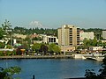
A shoreline park that overlooks the ship canal at Budd Inlet, the Olympic Mountains, and the Washington State Capitol building. The grounds were once an industrial yard for the Port of Olympia. The land was acquired and developed using local taxes as well as state and federal grants. The park provides picnic amenities and a boat launch for hand-held aquatic vessels. As of 2025[update], the southern portion of the shore is water access restricted due to continuing issues of contamination and other conditions deemed hazardous.[5][77]
Mixed-use park featuring an athletic complex, community garden, skate park, and trails. Intentionally built to flood as part of stormwater system, the grounds contain a wetland preserve.[78]
Additional parks that are multi-classified, and which may be undeveloped, include the 28th Avenue, Edison Street, Harrison Avenue, Kaiser Road, and Yelm Highway parcels. Grass Lake Nature Park is also listed under the classification.[2]:32
Other
The following parks in Olympia may not be uniquely classified under OPARD or may be under other jurisdictions, such as county, private, or state ownership, or oversight under the Port of Olympia.[2]:33
Begun by the city in 2010 and opened in 2014, the small commons area contains a public artesian well that has a flow rate of 10 US gallons (38L; 8.3impgal) per minute. Various local and government agencies partner to oversee the park.[79]
Black Lake Meadows
2021
3333 21st Avenue SW
45.02 acres (18.22ha)
Near Mottman Industrial Park, contains a looped wildlife trail and is part of the city's stormwater retention and filtration system. The site is known for birdwatching and the waters contain various migrating species of salmon and trout.[80][81]
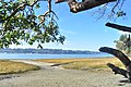
Under oversight of Thurston County.[82] Located on Budd Inlet, the forested site is named after the Burfoot family who once owned the land.[52] Amenities include gardens, 3.8 miles (6.1km) of hiking trails, picnic areas, and various wildlife viewing opportunities, including cutthroat trout, gray whales, orcas, salmon, sea lions, and tidal creatures at a 1,100 foot (340 metres) saltwater beach.[83][84]
McLane Dog Park
2021
4421 Mud Bay Rd NW
5.5 acres (2.2ha)
Originally owned by the Olympia School District, the grounds were leased to the city, constructing the park which contains areas for off-leash dogs.[85]
West Central Park
2012
Harrison Avenue and Division Street
0.0 acres (0ha)
Once an empty lot, the land was purchased by local resident, Alicia Elliot, and converted into a park. Under oversight of the non-profit West Central Park Project.[86]
The lake was constructed in 1951 by damming the estuary of the Deschutes River; it was meant to serve as a reflecting pool for the Capitol Building. A 1.5-mile (2.4km) paved and gravel trail loops around the lake; the Capitol campus can be accessed from the lake via the Heritage Park Trail, a 0.5-mile (0.80km), steep switchback pathway.[37]
Adjoining Capitol Lake,[37] the main feature is a circular splash pad fountain that contains numerous waterjets.[87]
Marathon Park
1970
Deschutes Parkway, west side of Capitol Lake
2.25 acres (0.91ha)
Originally constructed out of fill in 1970, the grounds were destroyed during the 2001 Nisqually earthquake, it was reopened in 2004.[88][89] A dedication ceremony and plaque honored the history and namesake of the site, the first U.S. women's Olympic marathon trial held in 1984, which started and ended at the park.[90][91] A footbridge trail crosses Capitol Lake's northern and middle basins; another pathway leads under I-5 and wetland areas to Tumwater's Interpretative Park.[37]
Previously known as Grass Lake Refuge,[93] contains a looped trail through an intact wetland area with hundreds of various bird and plant species. Contains an artwork effort known as Grass Lake Nature Park Public Art Project.[94]
Taylor Wetlands
2021
1300 Fones Rd SE
40.88 acres (16.54ha)
Used as part of the city's stormwater system, the grounds contain a connecting portion of the city's Woodland Trail.[95]
The Chehalis Western, Gate to Belmore, and Ralph Munro trails are under county oversight.[108]
The city created the Neighborhood Pathways Program in 2013 which, after approval from the Bicycle and Pedestrian Advisory Committee, helps to fund and construct pathways in communities to parks, streets, and other existing trails in Olympia. An early project was the connection of the Indian Creek neighborhood to the Karen Fraser Woodland Trail in 2016.[109]
The construction of bike corridors, used to "maximize safety and streamline travel" for Olympian bike riders especially near the downtown core, was first begun by 2016. The first corridor was a 2-mile (3.2km) stretch connecting Lions and Sylvester parks.[110] Garfield Nature Trail connects West Bay and Westside neighborhoods through a 7.4-acre (3.0ha)greenbelt that contains an unnamed ravine.[111]
The city began a commuter, "multi-modal" trail system known as the Capitol to Capitol (CTC) trail, linking existing trails throughout the city between Capitol Forest and the Washington State Capitol campus. By 2025, Grass Lake Nature Park became the first, "off-street" portion of the CTC to be completed.[112]
Undeveloped parcels
Undeveloped lands for potential future use as public parks include the Harrison Avenue Parcel, a 24-acre (9.7ha) plot in West Olympia purchased in 2011. Planning includes the connection of the site by trail to Grass Lake Nature Park.[113]
Other undeveloped properties include the 4.89-acre (1.98ha) Lilly Road Parcel,[114] the Log Cabin Road Parcel measured at 2.35 acres (0.95ha),[115] and the South Capitol Lots which encompasses less than an acre.[116]
The Yelm Highway Community Park, spanning over 80 acres (32ha),[f] was purchased by the city of Olympia in 2018 as a future park that was to also include a public school. A project plan was released in 2022 but the planned construction of an educational facility was found to no longer be needed.[117][118]As of 2025[update], the city has spent $14million at the site and is expected to receive additional funding as part of a $26million, 30-year bond also meant to upgrade the city's National Guard Armory. The Yelm Highway Community Park is planned to begin construction in 2026 and possibly completed by 2027.[119]
Venues
Properties under OPARD management or ownership include The Olympia Center, a 56,000-square-foot (5,200m2) community center,[2]:53,102 and the Olympia Armory, transferred by the state to the city in 2021.[2]:47,109-110
↑Listed years for Olympia parks and recreation sites depend on the dates being tied to an acquisition or purchase date, or when the park was beginning to be developed, or if the park had an official dedication. Several parks have multiple addresses due to having more than one access point. See sources throughout the article for the discrepancies.
↑The land trade for Decatur Woods Park is noted by the city to have taken place in 1988.[11]
↑The year for Woodruff Park denotes when the land was purchased by the city.
↑Watershed Park has multiple access points; the Henderson address is considered the main entrance, containing a parking lot.[56]
↑Reports on the acreage of Stevens Park list up to 24 acres (9.7ha). The discrepancy may be due to listing of the ballfields as a separate acreage from the overall park.[71][72]
↑The acreage for Yelm Highway Community Park varies based on the source, either as 83 acres (34ha) or 86 acres (35ha). See inline sources in section for the discrepancy.
This page is based on this Wikipedia article Text is available under the CC BY-SA 4.0 license; additional terms may apply. Images, videos and audio are available under their respective licenses.