Belmore, Washington | |
|---|---|
 Belmore  Belmore | |
| Coordinates: 46°59′14″N122°57′45″W / 46.98722°N 122.96250°W | |
| Country | United States |
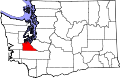
| State | Washington |
| County | Thurston |
| Time zone | UTC-8 (Pacific (PST)) |
| • Summer (DST) | UTC-7 (PDT) |
Belmore is an unincorporated community in Thurston County, in the U.S. state of Washington. [1] The community lies east of nearby Black Lake and is approximately southwest of Tumwater.