Rignall, Washington | |
|---|---|
 Rignall  Rignall | |
| Coordinates: 47°09′54″N122°55′22″W / 47.16500°N 122.92278°W | |
| Country | United States |
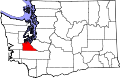
| State | Washington |
| County | Thurston |
| Time zone | UTC-8 (Pacific (PST)) |
| • Summer (DST) | UTC-7 (PDT) |
Rignall is an unincorporated community in Thurston County, in the U.S. state of Washington. [1] It is located on the Steamboat Island peninsula, overlooking the confluence of the Eld Inlet and Budd Inlet.