
Charles Yelverton O'Connor,, was an Irish engineer who is best known for his work in Western Australia, especially the construction of Fremantle Harbour, thought to be impossible, and the Goldfields Water Supply Scheme.

Northam is a town in the Wheatbelt region of Western Australia, situated at the confluence of the Avon and Mortlock Rivers. It is the largest town and regional centre in the Avon Valley region of the Central Wheatbelt. It is located approximately 97 kilometres north east of Perth, the capital city of Western Australia. At the time of the 2021 census, Northam had a population of 6,679.

Sir James Mitchell, was an Australian politician. He served as premier of Western Australia from 1919 to 1924 and from 1930 to 1933, as leader of the Nationalist Party. He then held viceregal office from 1933 to 1951, as acting governor from 1933 to 1948 and governor of Western Australia from 1948 until his death in 1951.

Southern Cross is a town in Western Australia, 371 kilometres east of state capital Perth on the Great Eastern Highway. It was founded in 1888 after gold prospectors Richard Greaves and Ted Paine during their October 1887 expedition successfully found gold, and gazetted in 1890. It is the major town and administrative centre of the Shire of Yilgarn. At the 2016 census, Southern Cross had a population of 680.
Spencers Brook is a waterway, locality and a district located within the Avon Valley in Western Australia.
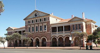
Coolgardie is a small town in Western Australia, 558 kilometres (347 mi) east of the state capital, Perth. It has a population of approximately 850 people.
The Eastern Goldfields Railway was built in the 1890s by the Western Australian Government Railways to connect Perth with the Eastern Goldfields at Coolgardie and Kalgoorlie.

Chidlow is a small community in the Shire of Mundaring approximately 45 kilometres east of Perth, Western Australia.
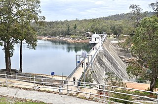
Mundaring Weir is a concrete gravity dam located 39 kilometres (24 mi) from Perth, Western Australia in the Darling Scarp. The dam and reservoir form the boundary between the suburbs of Reservoir and Sawyers Valley. The dam impounds the Helena River.

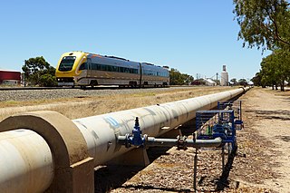
The Goldfields Water Supply Scheme is a pipeline and dam project that delivers potable water from Mundaring Weir in Perth to communities in Western Australia's Eastern Goldfields, particularly Coolgardie and Kalgoorlie. The project was commissioned in 1896 and completed in 1903.
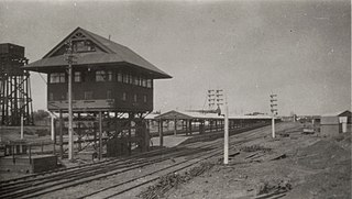
Kalgoorlie railway station is the easternmost attended station in Western Australia, located at the eastern terminus of the Eastern Goldfields Railway. It serves the city of Kalgoorlie. Beyond Kalgoorlie, the line continues east as the Trans-Australian Railway.

Clackline is a locality in the Wheatbelt region of Western Australia, about 80 kilometres (50 mi) east-north-east of Perth.
Broad Arrow is a ghost town in Western Australia, located 38 km north of Kalgoorlie and 633 km east of Perth. It is on the Kalgoorlie to Leonora Road.

Widgiemooltha is an abandoned town in Western Australia 631 kilometres (392 mi) east of Perth, Western Australia between Kambalda and Norseman in the Goldfields-Esperance region of Western Australia. It is found on the southern shoreline of Lake Lefroy.
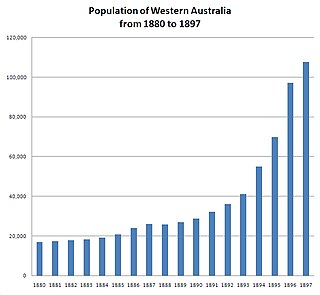
In the latter part of the nineteenth century, discoveries of gold at a number of locations in Western Australia caused large influxes of prospectors from overseas and interstate, and classic gold rushes. Significant finds included:
Credo is a former pastoral lease located about 70 kilometres (43 mi) north of Coolgardie in the Goldfields of Western Australia.
Boorabbin was a location on the narrow gauge Eastern Goldfields Railway in Western Australia. It was halfway between Southern Cross and Coolgardie.
Railway dams and reservoirs were used to supply water to an extensive railway system that ventured into low rainfall, and poor water quality areas of the inner regions of Western Australia in the 1890s.
The Kalgoorlie was a railway passenger service operated by the Western Australian Government Railways between November 1962 and November 1971.
Yerbillon, Western Australia was the location of Number 5 Pumping station on the Goldfields Water Supply Scheme, and is the location of the current pumping station number 11 on the pipeline. It was also located on the Eastern Goldfields Railway.