
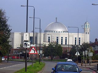
Mitcham is an area within the London Borough of Merton in Southwest London, England. It is centred 7.2 miles (11.6 km) southwest of Charing Cross. Originally a village in the county of Surrey, today it is mainly a residential suburb, and includes Mitcham Common. It has been a settlement throughout recorded history.

Morden is a district and town in south London, England, within the London Borough of Merton, in the ceremonial county of Greater London. It adjoins Merton Park and Wimbledon to the north, Mitcham to the east, Sutton to the south and Worcester Park to the west, and is around 8 miles (13 km) south-southwest of Charing Cross. Prior to the creation of Greater London in 1965, for local government purposes, Morden was in the administrative and historic county of Surrey.

Wimbledon is a district and town of south-west London, England, 7.0 miles (11.3 km) southwest of the centre of London at Charing Cross; it is the main commercial centre of the London Borough of Merton. Wimbledon had a population of 68,187 in 2011 which includes the electoral wards of Abbey, Wimbledon Town and Dundonald, Hillside, Wandle, Village, Raynes Park and Wimbledon Park.
The London Borough of Merton is a London borough in London, England. The borough was formed under the London Government Act 1963 in 1965 by the merger of the Municipal Borough of Mitcham, the Municipal Borough of Wimbledon and the Merton and Morden Urban District, all formerly within Surrey.

Yateley is a town and civil parish in the English county of Hampshire. It lies in the north-eastern corner of Hart District Council area. It includes the settlements of Frogmore and Darby Green to the east. It had a population of 21,011 at the 2001 census. The four wards that comprise Yateley and their 2001 populations are Yateley East (5,168), Yateley North (5,078), Yateley West (5,149), and Frogmore & Darby Green (5,616). The 2009 projection was 20,214, according to the Hart District Council website. Yateley Town Council is one of the few local councils to have been recognised under the national 'Quality Council' award scheme.

The White Hart was the personal badge of Richard II, who probably derived it from the arms of his mother, Joan "The Fair Maid of Kent", heiress of Edmund of Woodstock. It may also have been a pun on his name, as in "Rich-hart". In the Wilton Diptych, which is the earliest authentic contemporary portrait of an English king, Richard II wears a gold and enamelled white hart jewel, and even the angels surrounding the Virgin Mary all wear white hart badges. In English Folklore, the white hart is associated with Herne the Hunter.

Elstead is a civil parish in Surrey, England with shops, houses and cottages spanning the north and south sides of the River Wey; development is concentrated on two roads that meet at a central green. It includes Pot Common its southern neighbourhood. Hamlets in the parish, marginally separated from the village centre, are Charleshill and Elstead Common, both rich in woodland. Elstead lies between Farnham and Godalming on the B3001 road about 2.2 miles (3.6 km) west of the A3 Milford interchange.

Sherston is a village and civil parish about 5 miles (8 km) west of Malmesbury in Wiltshire, England. The parish is bounded to the north by the county boundary with Gloucestershire, and to the southeast by the Fosse Way, a Roman road. The parish includes the hamlets of Easton Town, immediately east of Sherston; Pinkney, further east along the Malmesbury road; and Willesley, to the north.

Erlestoke is a village and civil parish in Wiltshire, England, on the northern edge of Salisbury Plain. The village lies about 6 miles (10 km) east of Westbury and the same distance southwest of Devizes.

Ludgershall is a town and civil parish 16 miles (26 km) north east of Salisbury, Wiltshire, England. It is on the A342 road between Devizes and Andover. The parish includes Faberstown which is contiguous with Ludgershall, and the hamlet of Biddesden which lies 2 miles (3.2 km) to the east, on the border with Hampshire.

Stratfield Mortimer is a village and civil parish, just south of Reading, in the English county of Berkshire and unitary authority area of West Berkshire.

Ewell is a town in the borough of Epsom and Ewell in Surrey, England. It is approximately 12 miles (19 km) south of central London and 2 miles (3.2 km) northeast of Epsom. In the 2011 Census, the town had a population of 34,872. The majority of which (73%) is in the ABC1 social class, except the Ruxley Ward that is C2DE.

Birkenhead Park is a major public park located in the centre of Birkenhead, Merseyside, England. It was designed by Joseph Paxton and opened on 5 April 1847.
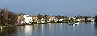
Strand-on-the-Green is one of Chiswick's four medieval villages, and a "particularly picturesque" riverside area in West London. It is a conservation area, with many "imposing" listed buildings beside the River Thames; a local landmark, the Kew Railway Bridge that crosses the River Thames and the Strand, is itself Grade II listed. Oliver's Island is just offshore.

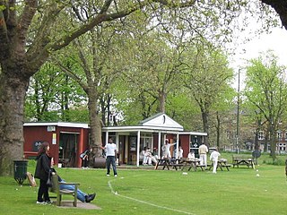
Mitcham Cricket Green is a cricket ground in Mitcham, south London. It is the home of Mitcham Cricket Club and is reportedly the oldest cricket ground still in use, having been used for cricket since 1685.

Mitcham Cricket Club is reported by The Independent to be the oldest cricket club in existence, with the club having played cricket on Mitcham Cricket Green since 1685. The club was reportedly watched by Lord Nelson during his time in the area.
Kew Green is a large open space in Kew in west London. Owned by the Crown Estate, it is leased to the London Borough of Richmond-upon-Thames. It is roughly triangular in shape, and its open grassland, framed with broadleaf trees, extends to about thirty acres. Kew Green is overlooked by a mixture of period townhouses, historic buildings and commercial establishments. Since the 1730s, Kew Green has been a venue for cricket matches.

2–3 Pavilion Buildings in Brighton is a former office building which has been converted into a bar. It was constructed in 1934 as the new head office of the Brighton & Hove Herald, a "leading provincial weekly" newspaper serving the borough and seaside resort of Brighton and its neighbour Hove in southeast England. The Neo-Georgian offices were built to the design of prolific local architect John Leopold Denman and feature decorative carvings by Joseph Cribb. After production of the Herald ceased in the 1970s, the building was used by an insurance company and then as a bar. A firm of insolvency practitioners also occupies part of the premises. Vestigial remains of the neighbouring Royal Pavilion's guest bedrooms were incorporated into the building's rear elevation. The building is on Brighton and Hove City Council's Local List of Heritage Assets and is in a conservation area.

Burnett Wedlake "Burn" Bullock was an English first-class cricketer who played for Surrey in a few matches between 1922 and 1924. He was born in Redhill, Surrey and died in Balham, London.

