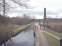
The East Lancashire Railway is a twelve-and-a-half-mile (20 km) heritage railway line in North West England which runs between Heywood, Greater Manchester and Rawtenstall in Lancashire. There are intermediate stations at Bury Bolton Street, Burrs Country Park, Summerseat and Ramsbottom, with the line crossing the border into Rossendale serving Irwell Vale and Rawtenstall. Before closure, the line terminated at Bacup.

Bury is a market town on the River Irwell in the Metropolitan Borough of Bury, Greater Manchester, England. which had a population of 81,101 in 2021 while the wider borough had a population of 193,846.

Rossendale is a local government district with borough status in Lancashire, England. Its council is based in Bacup and its largest town is Rawtenstall. It also includes the towns of Haslingden and Whitworth. The borough is named after the Rossendale Valley, the upper part of the River Irwell.

The River Irwell is a tributary of the River Mersey in north-west England. It rises at Irwell Springs on Deerplay Moor, approximately 1+1⁄2 miles north of Bacup and flows southwards for 39 mi (63 km) to meet the Mersey near Irlam. The Irwell marks the boundary between Manchester and Salford, and its lower reaches have been canalised and now form part of the Manchester Ship Canal.
Ramsbottom is a market town in the Metropolitan Borough of Bury, Greater Manchester, England. The population at the 2011 census was 17,872.

The Irwell Sculpture Trail is the largest public art scheme in England, commissioning regional, national and international artists. The Trail includes 28 art pieces and follows a well established 30-mile (48 km) footpath stretching from Salford Quays through Bury into Rossendale and up to the Pennines above Bacup.

Radcliffe is a market town in the Metropolitan Borough of Bury, Greater Manchester, England. It lies in the Irwell Valley 7 miles (11 km) northwest of Manchester and 3 miles (5 km) southwest of Bury and is contiguous with Whitefield to the south. The disused Manchester Bolton & Bury Canal bisects the town.

Tottington is a town in the Metropolitan Borough of Bury in Greater Manchester, England, on the edge of the West Pennine Moors.

Pendlebury is a town in the City of Salford, Greater Manchester, England. The population at the 2011 Census was 13,069. It lies 4 miles (6 km) north-west of Manchester, 3 miles (5 km) north-west of Salford and 6 miles (10 km) south-east of Bolton.

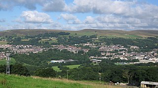
Rawtenstall is a town in the borough of Rossendale, Lancashire, England. The town lies 15 miles north of Manchester, 22 miles east of Preston and 45 miles south east of Lancaster. The town is at the centre of the Rossendale Valley. It had a population of 23,000.

Kearsley is a town in the Metropolitan Borough of Bolton, Greater Manchester, England. The population at the 2011 census was 14,212. Within the Historic County of Lancashire, it lies 8 miles (13 km) northwest of Manchester, 5 miles (8 km) southwest of Bury and 3+3⁄4 miles (6 km) south of Bolton.
Brandlesholme is an area in the town of Bury in Greater Manchester, England. The boundary between Brandlesholme, Bury and the North Manor area of Bury is Wood Road Lane, close to the junction of Brandlesholme Road and Longsite Road.
Clifton Country Park is a local nature reserve in the Irwell Valley at Clifton, Greater Manchester, England. Situated next to a double bend in the River Irwell, it is north east of the Manchester to Preston railway line and the A666, where it is accessible via Clifton House Road opposite Clifton Cricket Club. Junction 16 of the M60 motorway is only about ¼ mile away to the south east.

Drinkwater Park is situated in the Irwell Valley on the western border of Prestwich, near Manchester, bounded by the River Irwell to the west, Agecroft Road and Rainsough Brow (A6044) to the south, Butterstile Lane and Carr Clough estate to the east and Bunkers Hill to the north. The park is administered by Forestry England and is part of Prestwich Forest Park, which also incorporates Philips Park, Mere Clough, Prestwich Clough, Forest Bank Park in Pendlebury and Waterdale Meadow.
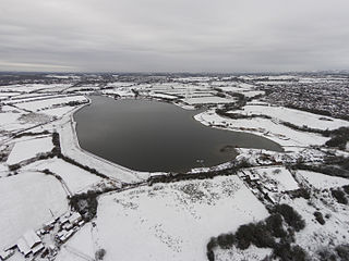
The Manchester Bury & Bolton Reservoir, commonly called Elton Reservoir, is located near the A58 Bolton Road in Greater Manchester, about 3 km (1.8 mi) south west of the town of Bury. Constructed in 1842 at the height of the canal era, it remains today as legacy of the industrial era and a major leisure facility for residents of Bury, Bolton and North Manchester.

Moses Gate Country Park, part of which is also known as Crompton Lodges, is a 750 acre site situated at Moses Gate in the Croal and Irwell Valleys 3 miles (4.8 km) south of Bolton town centre on the A6053 road which connects Farnworth to Little Lever. It is a Local Nature Reserve.
Moses Gate is a small district of Farnworth, in the Metropolitan Borough of Bolton, Greater Manchester, England. Historically in Lancashire, it lies 2.6 miles (4.2 km) southeast of Bolton town centre and 10.8 miles (17.4 km) northwest of the city of Manchester.

The Irwell Valley in North West England extends from the Forest of Rossendale through the cities of Salford and Manchester. The River Irwell runs through the valley, along with the River Croal.
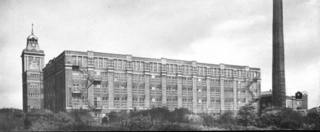
Pilot Mill, Bury is a four-storey cotton spinning mill in Bury, Greater Manchester, England. It was built in 1905 for the Pilot Spinning Co. It was taken over by the Lancashire Cotton Corporation in 1939. The mill closed in 1962 and was later sold to Antler Luggage. The Mill is currently occupied by Baum Trading Ltd and Metzuyan Ltd they have opened a retail outlet with an on site cafe.

Kirklees Valley Local Nature Reserve is a nature reserve in the Metropolitan Borough of Bury, that stretches from Greenmount in the north, Bury in the south, and Tottington in the west. It was declared a nature reserve in October 2010 under the 1949 National Parks and Access to the Countryside Act.