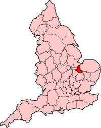
Cambridgeshire is a ceremonial and non-metropolitan county in the East of England government statistical region, and popularly known as one of the three counties of East Anglia. The largest city is Peterborough, followed by the county town of Cambridge. In 1974, modern Cambridgeshire was created through the amalgamation of Cambridgeshire and Isle of Ely with Huntingdon and Peterborough, which including the historic counties of Huntingdonshire and the Soke of Peterborough. A majority of the county is locally governed by Cambridgeshire County Council in combination with the lower tier non-metropolitan district councils of Cambridge, East Cambridgeshire, Fenland, Huntingdonshire, and South Cambridgeshire. Peterborough however is governed as a unitary authority with one council, Peterborough City Council. It is bordered by Lincolnshire to the north, Norfolk to the north-east, Suffolk to the east, Essex and Hertfordshire to the south, and Bedfordshire and Northamptonshire to the west.

The Anarchy was a civil war in England and Normandy between 1138 and 1153, which resulted in a widespread breakdown in law and order. The conflict was a war of succession precipitated by the accidental death of William Adelin who drowned in the sinking of the White Ship in 1120. Henry sought to be succeeded by his daughter, known as Empress Matilda, but was only partially successful in convincing the nobility to support her. On Henry's death in 1135, his nephew Stephen of Blois seized the throne, with the help of Stephen's brother Henry of Blois, who was the bishop of Winchester. Stephen's early reign saw fierce fighting with disloyal English barons, rebellious Welsh leaders, and Scottish invaders. Following a major rebellion in the south-west of England, Matilda invaded in 1139 with the help of her half-brother Robert of Gloucester.

Castles have played an important military, economic and social role in Great Britain and Ireland since their introduction following the Norman invasion of England in 1066. Although a small number of castles had been built in England in the 1050s, the Normans began to build motte and bailey and ringwork castles in large numbers to control their newly occupied territories in England and the Welsh Marches. During the 12th century the Normans began to build more castles in stone – with characteristic square keep – that played both military and political roles. Royal castles were used to control key towns and the economically important forests, while baronial castles were used by the Norman lords to control their widespread estates. David I invited Anglo-Norman lords into Scotland in the early 12th century to help him colonise and control areas of his kingdom such as Galloway; the new lords brought castle technologies with them and wooden castles began to be established over the south of the kingdom. Following the Norman invasion of Ireland in the 1170s, under Henry II, castles were established there too.
The Isle of Ely is a historic region around the city of Ely in Cambridgeshire, England. Between 1889 and 1965, it formed an administrative county.
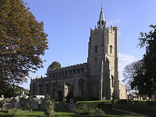
Burwell is a village and civil parish in Cambridgeshire, England, some 10 miles north-east of Cambridge. It lies on the south-east edge of the Fens. Westward drainage is improved by Cambridgeshire lodes (waterways), including Burwell Lode, a growth factor in the village. A population of 6,309 in the 2011 census was put at 6,417 in 2019.

East Cambridgeshire is a local government district in Cambridgeshire, England. Its council is based in Ely. The population of the District Council at the 2011 Census was 83,818. The district was formed on 1 April 1974 with the merger of Ely Urban District, Ely Rural District, and Newmarket Rural District. The district is divided into 14 electoral divisions, which return a total of 28 councillors. The council has been controlled by the Conservative Party since 2007.

Slighting is the deliberate damage of high-status buildings to reduce their value as military, administrative or social structures. This destruction of property sometimes extended to the contents of buildings and the surrounding landscape. It is a phenomenon with complex motivations and was often used as a tool of control. Slighting spanned cultures and periods, with especially well-known examples from the English Civil War in the 17th century.

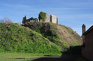
Cambridge Castle, locally also known as Castle Mound, is located in Cambridge, Cambridgeshire, England. Originally built after the Norman conquest to control the strategically important route to the north of England, it played a role in the conflicts of the Anarchy, the First and Second Barons' Wars. Hugely expanded by Edward I, the castle then fell rapidly into disuse in the late medieval era, its stonework recycled for building purposes in the surrounding colleges. Cambridge Castle was refortified during the English Civil War but once again fell into disuse, used primarily as the county gaol. The castle gaol was finally demolished in 1842, with a new prison built in the castle bailey. This prison was demolished in 1932, replaced with the modern Shire Hall, and only the castle motte and limited earthworks still stand. The site is open to the public daily and offers views over the historic buildings of the city.

Restormel Castle lies by the River Fowey near Lostwithiel in Cornwall, England, UK. It is one of the four chief Norman castles of Cornwall, the others being Launceston, Tintagel and Trematon. The castle is notable for its perfectly circular design. Although once a luxurious residence of the Earl of Cornwall, the castle was all but ruined by the 16th century. It was briefly reoccupied and fought over during the English Civil War but was subsequently abandoned. It is now in the care of English Heritage and open to the public.
Castle Acre Castle and town walls are a set of ruined medieval defences built in the village of Castle Acre, Norfolk. The castle was built soon after the Norman Conquest by William de Warenne, the Earl of Surrey, at the intersection of the River Nar and the Peddars Way. William constructed a motte-and-bailey castle during the 1070s, protected by large earthwork ramparts, with a large country house in the centre of the motte. Soon after, a small community of Cluniac monks were given the castle's chapel in the outer bailey; under William, the second earl, the order was given land and estates to establish Castle Acre Priory alongside the castle. A deer park was created nearby for hunting.
Eye Castle is a motte and bailey medieval castle with a prominent Victorian addition in the town of Eye, Suffolk. Built shortly after the Norman conquest of England in 1066, the castle was sacked and largely destroyed in 1265. Sir Edward Kerrison built a stone house on the motte in 1844: the house later decayed into ruin, becoming known as Kerrison's Folly in subsequent years.
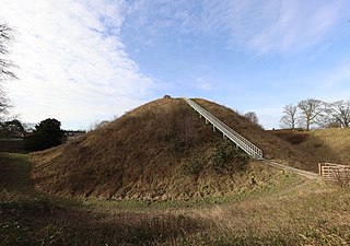
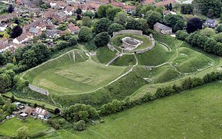
Thetford Castle is a medieval motte and bailey castle in the market town of Thetford in the Breckland area of Norfolk, England. The first castle in Thetford, a probable 11th-century Norman ringwork called Red Castle, was replaced in the 12th century by a much larger motte and bailey castle on the other side of the town. This new castle was largely destroyed in 1173 by Henry II, although the huge motte, the second largest man-made mound in England, remained intact. The motte, recognised as a scheduled monument, now forms part of a local park, and the remains are known variously as Castle Hill, Castle Mound and Military Parade.
A back lane is a roadway often found in a planned medieval village running parallel to the main street at the other end of burgage plots. There may be a back lane on each side of the main street which, together with the main street itself, provides a rectangular framework for the development of the village. Although the burgage plot was used for small-scale activities such as livestock or orchards, the back lane frequently divided the village from the main agricultural area such as the open fields.

Ely is a cathedral city in the East Cambridgeshire district of Cambridgeshire, England, about 14 miles (23 km) north-northeast of Cambridge and 80 miles (130 km) from London.

Adulterine castles were fortifications built in England during the 12th century without royal approval, particularly during the civil war of the Anarchy between 1139 and 1154.

Berkhamsted Castle is a Norman motte-and-bailey castle in Berkhamsted, Hertfordshire. The castle was built to obtain control of a key route between London and the Midlands during the Norman conquest of England in the 11th century. Robert of Mortain, William the Conqueror's half brother, was probably responsible for managing its construction, after which he became the castle's owner. The castle was surrounded by protective earthworks and a deer park for hunting. The castle became a new administrative centre of the former Anglo-Saxon settlement of Berkhamsted. Subsequent kings granted the castle to their chancellors. The castle was substantially expanded in the mid-12th century, probably by Thomas Becket.

Montacute Castle was a castle built on a hill overlooking the village of Montacute, Somerset, England.
Belsar's Hill is a hillfort near Willingham, Cambridgeshire, England.


