Bury Town Hall

Last updated

Bury Town Hall
Bury Town Hall.jpg
Front view of Bury Town Hall, February 2008
LocationKnowsley Street, Bury
Coordinates 53°35′25″N2°18′00″W / 53.5902°N 2.3001°W / 53.5902; -2.3001 Coordinates: 53°35′25″N2°18′00″W / 53.5902°N 2.3001°W / 53.5902; -2.3001
Built1954
ArchitectReginald Edmonds
Architectural style(s) Neo-Georgian style
Greater Manchester UK location map 2.svg
Red pog.svg
Shown in Greater Manchester

Bury Town Hall is a municipal building in Knowsley Street, Bury, Greater Manchester, England. The town hall, which is the headquarters of Metropolitan Borough of Bury, is a locally listed building. [1]

History

Until the mid-20th century, Derby Hall on Market Street accommodated the local council offices, but was no longer fit for purpose. [2] The new building was designed, following an architectural competition, by Reginald Edmonds in the Neo-Georgian style in the 1930s. [3] Construction was delayed by the Second World War and it was only officially opened by Queen Elizabeth II on 22 October 1954. [4] [5] [6] The design incorporated an assembly hall which became known as the Elizabethan Suite. [7]

The Whitehead Clock Tower, a memorial to Walter Whitehead, a local surgeon, dedicated in June 1914 [8] and George Frampton's 'cheering fusilier', a tribute to those soldiers who had died in the Second Boer War, erected in 1920, [9] are both structures which predate the current town hall and stand in Whitehead Garden to the south of the building. [10] The garden itself was a gift from Sidney and Katherine Whitehead of Stormer Hill in Bury to commemorate the lives of seven people who were killed in Chapel Street by a V-1 flying bomb on 24 December 1944 during the Second World War. [11] [12]

The town hall was the headquarters of the County Borough of Bury until 1974 when it became the headquarters of the enlarged Metropolitan Borough of Bury. [13] A three-dimensional relief of the enlarged borough's coat of arms, designed by Diana Childs, was installed in the council chamber in the mid-1970s. [14] The Prince of Wales visited the town hall for a lunch meeting with the civic dignitaries on 14 December 1977. [15]

In July 1992 Queen Elizabeth II chose the town hall as her destination on her inaugural journey on the Manchester Metrolink; she had lunch in the building on her arrival. [16] [17]

The building had to be closed for weddings and other public events in July 2020 after part of the ceiling on the second floor collapsed. [18]

Related Research Articles

<span class="mw-page-title-main">Metropolitan Borough of Rochdale</span> Borough of Greater Manchester, England

The Metropolitan Borough of Rochdale is a metropolitan borough of Greater Manchester in England. Its largest town is Rochdale and the wider borough covers other outlying towns and villages with a population of 206,500 at the 2011 census. It is the ninth-largest district by population in Greater Manchester.

<span class="mw-page-title-main">Bury, Greater Manchester</span> Market town in Greater Manchester, England

Bury is a market town on the River Irwell in the Metropolitan Borough of Bury, Greater Manchester, England. which had an estimated population of 78,723 in 2015.

<span class="mw-page-title-main">Rochdale</span> Town in Greater Manchester, England

Rochdale is a town in Greater Manchester, England, at the foothills of the South Pennines in the dale of the River Roch, 5 miles (8.0 km) northwest of Oldham and 10 miles (16.1 km) northeast of Manchester. It is the administrative centre of the Metropolitan Borough of Rochdale, which had a population of 211,699 in the 2011 census.

<span class="mw-page-title-main">Whitefield, Greater Manchester</span> Town in Greater Manchester, England

Whitefield is a town in the Metropolitan Borough of Bury, Greater Manchester, England. It lies on undulating ground above the Irwell Valley, along the south bank of the River Irwell, 3 miles (4.8 km) southeast of Bury, and 5 miles (8.0 km) northwest of Manchester. Prestwich and the M60 motorway lie just to the south.

<span class="mw-page-title-main">Milnrow</span> Human settlement in England

Milnrow is a town within the Metropolitan Borough of Rochdale, in Greater Manchester, England. It lies on the River Beal at the foothills of the South Pennines, and forms a continuous urban area with Rochdale. It is 2 miles (3.2 km) east of Rochdale town centre, 10 miles (16.1 km) north-northeast of Manchester, and spans from Windy Hill in the east to the Rochdale Canal in the west. Milnrow is adjacent to junction 21 of the M62 motorway, and includes the village of Newhey, and hamlets at Tunshill and Ogden.

<span class="mw-page-title-main">Derby Hall, Bury</span> Historic site in Bury

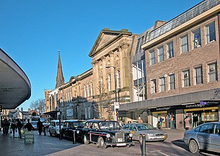
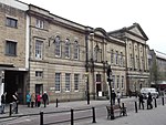
The Derby Hall is a Victorian neo-classical building situated on Market Street in the centre of Bury, Greater Manchester, England. It is a Grade II listed building.

<span class="mw-page-title-main">Stretford</span> Town in Greater Manchester, England

Stretford is a market town in Trafford, Greater Manchester, England. It is situated on flat ground between the River Mersey and the Manchester Ship Canal, 3.8 miles (6.1 km) south of Manchester city centre, 3.0 miles (4.8 km) south of Salford and 4.2 miles (6.8 km) north-east of Altrincham. Stretford borders Chorlton-cum-Hardy to the east, Moss Side and Whalley Range to the south-east, Hulme to the north-east, Urmston to the west, Salford to the north, and Sale to the south. The Bridgewater Canal bisects the town.

<span class="mw-page-title-main">Radcliffe, Greater Manchester</span> Town in Greater Manchester, England

Radcliffe is a market town in the Metropolitan Borough of Bury, Greater Manchester, England. It lies in the Irwell Valley 7 miles (11 km) northwest of Manchester and 3 miles (5 km) southwest of Bury and is contiguous with Whitefield to the south. The disused Manchester Bolton & Bury Canal bisects the town.

<span class="mw-page-title-main">Tottington, Greater Manchester</span> Human settlement in England

Tottington is a town in the Metropolitan Borough of Bury in Greater Manchester, England, on the edge of the West Pennine Moors.

<span class="mw-page-title-main">Fusilier Museum</span> War museum in Moss Street, Bury

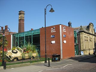
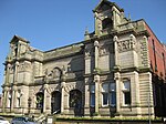
The Fusilier Museum is a museum in Bury, Greater Manchester, England. Its collection includes the uniforms, medal and artefacts of the Lancashire Fusiliers.

<span class="mw-page-title-main">Grade I listed buildings in Greater Manchester</span>

There are 48 Grade I listed buildings in Greater Manchester, England. In the United Kingdom, the term listed building refers to a building or other structure officially designated as being of special architectural, historical or cultural significance; Grade I structures are those considered to be "buildings of exceptional interest". In England, the authority for listing under the Planning Act 1990 rests with Historic England, a non-departmental public body sponsored by the Department for Culture, Media and Sport.

<span class="mw-page-title-main">Lancashire Fusiliers War Memorial</span> War memorial in Bury, UK

The Lancashire Fusiliers War Memorial is a First World War memorial dedicated to members of the Lancashire Fusiliers killed in that conflict. Outside the Fusilier Museum in Bury, Greater Manchester, in North West England, it was unveiled in 1922—on the seventh anniversary of the landing at Cape Helles, part of the Gallipoli Campaign in which the regiment suffered particularly heavy casualties. The memorial was designed by Sir Edwin Lutyens. Lutyens was commissioned in light of a family connection—his father and great uncle were officers in the Lancashire Fusiliers, a fact noted on a plaque nearby. He designed a tall, slender obelisk in Portland stone. The regiment's cap badge is carved near the top on the front and rear, surrounded by a laurel wreath. Further down are inscriptions containing the regiment's motto and a dedication. Two painted stone flags hang from the sides.

<span class="mw-page-title-main">Castle Armoury, Bury</span>

The Castle Armoury is a military installation in Bury, Greater Manchester, England.

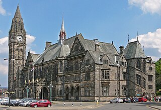
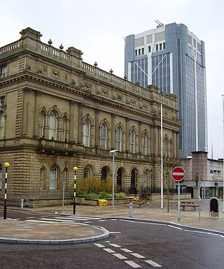
Bury is a town in the Metropolitan Borough of Bury, Greater Manchester, England, and it is unparished. The central area of the town and the surrounding countryside contain 67 listed buildings that are recorded in the National Heritage List for England. Of these, one is listed at Grade I, the highest of the three grades, three are at Grade II*, the middle grade, and the others are at Grade II, the lowest grade.

<span class="mw-page-title-main">Ashton Town Hall</span> Municipal building in Ashton, Greater Manchester, England

Ashton Town Hall is a public building on Katherine Street in Ashton-under-Lyne. It is a Grade II listed building.

<span class="mw-page-title-main">Blackburn Town Hall</span> Municipal building in Blackburn, Lancashire, England

Blackburn Town Hall is a municipal building in King William Street, Blackburn, England. The town hall, which is the headquarters of Blackburn with Darwen Borough Council, is a Grade II listed building.

<span class="mw-page-title-main">Oldham Civic Centre</span> Municipal building in Oldham, Greater Manchester, England

Oldham Civic Centre is a municipal building in West Street, Oldham, England.

<span class="mw-page-title-main">Eccles Town Hall</span> Municipal building in Eccles, Greater Manchester, England

Eccles Town Hall is a municipal building in Church Street, Eccles, Greater Manchester, England. The town hall was the headquarters of Eccles Borough Council until the council was abolished in 1974.

<span class="mw-page-title-main">Radcliffe Town Hall</span> Municipal building in Radcliffe, Greater Manchester, England

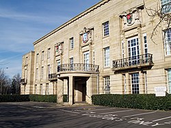
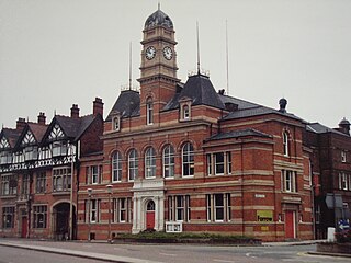
Radcliffe Town Hall is a municipal structure in Spring Lane in Radcliffe, Greater Manchester, England. The town hall, which was the headquarters of Radcliffe Borough Council, is a locally listed building.

<span class="mw-page-title-main">Earlestown Town Hall</span> Municipal building in Earlestown, Merseyside, England

Earlestown Town Hall is a municipal building in Market Street in Earlestown, Merseyside, England. The building, which was the headquarters of Newton-le-Willows Urban District Council, is a Grade II listed building.

References

  1. "Draft local list". Bury Council. Retrieved 24 April 2021.
  2. "Bury' Met set to re-open after £4.6 million refurbishment". About Manchester. 6 December 2016. Retrieved 8 July 2020.
  3. "Reginald Edmonds FRIBA". Old Edwardians Gazette. Retrieved 8 July 2020.
  4. Frain, Sean (2013). The Bury Book of Days. The History Press. ISBN   978-0752485829.
  5. "Counties And Metropolitan Districts In England". Hansard. 6 July 1972. Retrieved 8 July 2020.
  6. "Lancashire Only - Queen Continues Lancashire Tour 1954". British Pathe. Retrieved 8 July 2020.
  7. "About the Elizabethan Suite". Bury Council. Retrieved 8 July 2020.
  8. Historic England. "Clock Tower, Whitehead or Tower Gardens (1067232)". National Heritage List for England . Retrieved 8 July 2020.
  9. Historic England. "Lancashire Fusiliers Boer War Memorial (1440258)". National Heritage List for England . Retrieved 8 July 2020.
  10. Wyke, Terry; Cocks, Harry (2004). Public Sculpture of Greater Manchester. Liverpool University Press. p. 256. ISBN   978-0853235675.
  11. "The Whitehead Garden". Imperial War Museum. Retrieved 8 July 2020.
  12. "V1 flying bomb site, Chapel Street, Tottington near Bury". Air Crash Sites. 7 May 2010. Retrieved 8 July 2020.
  13. "Bury - A brief history". Bury Council. Retrieved 8 July 2020.
  14. "Death of town arts supporter". Bury Times. 21 September 2007. Retrieved 8 July 2020.
  15. "December 13-14". The Bolton News. 16 December 2002. Retrieved 8 July 2020.
  16. "Phase 1 of Metrolink". Transport for Greater Manchester. Retrieved 8 July 2020.
  17. "Court Circular". The Independent. 18 July 1992. Retrieved 8 July 2020.
  18. "Bury town hall closed after ceiling collapses - four weddings have had to be relocated". Manchester Evening News. 10 July 2020. Retrieved 20 July 2020.