Listed buildings in Radcliffe, Greater Manchester

Last updated

Radcliffe is a town in the Metropolitan Borough of Bury, Greater Manchester, England, and includes the village of Ainsworth and the countryside around and between them. It is unparished, and contains 31 listed buildings that are recorded in the National Heritage List for England. Of these, two are listed at Grade I, the highest of the three grades, three are at Grade II*, the middle grade, and the others are at Grade II, the lowest grade. The listed buildings include farmhouses and farm buildings, private houses, churches and associated items, a ruined pele tower, a public house, two structures associated with the demolished Mount Sion Mill, a disused railway viaduct, and a war memorial.

Contents

Key

Map all coordinates using: OpenStreetMap  
Download coordinates as: KML
GradeCriteria [1]
IBuildings of exceptional interest, sometimes considered to be internationally important
II*Particularly important buildings of more than special interest
IIBuildings of national importance and special interest

Buildings

Name and locationPhotographDateNotesGrade
Church of St Mary and St Bartholomew
53°33′52″N2°18′29″W / 53.56448°N 2.30811°W / 53.56448; -2.30811 (St Mary's Church)
Parish Church of St Mary, Radcliffe.jpg
14th centuryThe church was altered during the following centuries, the tower is dated 1665, the chancel was rebuilt in 1817, and extensions and restoration were carried out in 1870 and in 1905 by J. Medland Taylor. The church consists of a nave with a clerestory, a north aisle with a transept, a south aisle, a chancel with a north vestry and a south chapel, and a west tower. The tower has clock faces and an embattled parapet with corner pinnacles. [2] [3] I
Radcliffe Tower
53°33′50″N2°18′35″W / 53.56383°N 2.30978°W
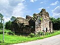
 / 53.56383; -2.30978 (Radcliffe Tower)
Radcliffe Tower.jpg
1403This is a ruined pele tower, and all that remains of a former manor house. It is in stone, and measures 10.5 yards (9.6 m) by 19 yards (17 m), and is about 20 feet (6.1 m) high. There are almost-round-headed arches on three sides, and a doorway on the other side. The tower is also a scheduled monument. [4] [5] [6] I
Dearden Fold Farmhouse
53°35′15″N2°21′59″W / 53.58753°N 2.36648°W / 53.58753; -2.36648 (Dearden Fold Farmhouse)
16th century (probable)Originally a hall with cross-wings, the farmhouse is timber framed with stone walls and some brown brick, and with a stone slab roof. There are two storeys and four bays, the outer bays slightly projecting and gabled. On the front is a gabled porch, and the windows are replacement casements. Inside is an inglenook and a timber framed cross-wall. [7] [8] II*
Barrack Fold Farmhouse,
stable and barn
53°35′44″N2°21′38″W / 53.59550°N 2.36069°W / 53.59550; -2.36069 (Barrack Fold Farmhouse)
17th centuryThe buildings are in sandstone and brick, the house and stable have roofs of stone-slate, and the barn has a Welsh slate roof. The farmhouse has two storeys, two bays and a gabled cross-wing on the right. The doorway has a dated and inscribed lintel, and the windows are mullioned. The barn to the north has a cart entrance with a timber lintel and quoined jambs; the other cart entrance is blocked. The other openings are doors, windows, and ventilation holes in diamond patterns. The stable block is attached at right angles to the barn. [9] II
Coggra Fold Farmhouse
53°34′29″N2°21′34″W / 53.57471°N 2.35952°W / 53.57471; -2.35952 (Coggra Fold Farmhouse)
17th centuryA stone house, partly rebuilt in brick, with two storeys and an L-shaped plan. At the end of the shorter wing is a massive projecting chimney with a decoration of a tree and other objects in plaster. [10] II
Scotson Fold Farmhouse
53°33′33″N2°20′17″W / 53.55923°N 2.33794°W / 53.55923; -2.33794 (Scotson Fold Farmhouse)
17th century (or earlier)The farmhouse is timber framed with later brick infill on a stone plinth. It has 2+12 storeys and three bays, and contains two windows with modern glazing. [11] II
Tythe Barn
53°33′54″N2°18′39″W / 53.56487°N 2.31071°W / 53.56487; -2.31071 (Tythe Barn)
17th century (or earlier)The barn, later used for other purposes, is in stone, partly rendered and has a stone slab roof. There is a cart entrance in the centre, and a window to the right. [12] II
Barn, Dearden Fold Farm
53°35′16″N2°22′00″W / 53.58766°N 2.36670°W / 53.58766; -2.36670 (Barn, Dearden Fold Farm)
1691The barn is in stone with quoins and a stone slab roof. It has two cart doors with depressed-arched heads, and a doorway with a dated and initialled lintel. [7] [13] II
Smith Fold Farmhouse
53°34′44″N2°22′11″W / 53.57900°N 2.36975°W / 53.57900; -2.36975 (Smith Fold Farmhouse)
17th or early 18th centuryA stone farmhouse with a slate roof, two storeys and three bays. In the right bay is a gabled porch, and the windows are mullioned. [14] II
Presbyterian Chapel, Ainsworth
53°35′20″N2°21′34″W / 53.58895°N 2.35958°W
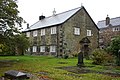
 / 53.58895; -2.35958 (Presbyterian Chapel)
Ainsworth Presbyterian Chapel - geograph.org.uk - 84343.jpg
1715The chapel was enlarged in 1773 and altered and repaired in 1845. It is in stone with quoins, and has two storeys and four bays. Above the doorway is a pediment with an inscription, and along the sides are two tiers of chamfered mullioned windows. On the west gable is a double bellcote with Ionic pilasters and capitals with carved faces. Inside the chapel are box pews and a gallery on three sides. [15] [16] II*
Barn, Davenport Farm
53°35′28″N2°21′55″W / 53.59100°N 2.36532°W / 53.59100; -2.36532 (Barn, Davenport Farm)
1723The barn, later converted for other uses, is in stone with the north wall partly rebuilt in brick, and has a slate roof. There are three doorways, and in the gable end is a shield with a foliated border, inscribed with initials and the date. [17] II
Old Hall Farmhouse
53°34′41″N2°19′09″W / 53.57794°N 2.31923°W / 53.57794; -2.31923 (Old Hall Farmhouse)
Early 18th centuryThe farmhouse was refronted after a fire in 1872. It is in red brick with quoins, a sill band, a moulded gutter cornice, and a slate roof. There are two storeys, five bays, and a recessed two-bay extension on the right. The windows are sashes, and above the door is a fanlight. [18] II
Gate piers, Old Hall Farm
53°34′41″N2°19′10″W / 53.57804°N 2.31958°W / 53.57804; -2.31958 (Gate piers, Old Hall Farm)
Early 18th century (probable)The gate piers are in rusticated stone, and have ball finials. [19] II
Duke William Inn
53°35′20″N2°21′35″W / 53.58883°N 2.35983°W / 53.58883; -2.35983 (Duke William Inn)
Duke William - geograph.org.uk - 337365.jpg
1737The public house probably contains earlier material. It is in stone with two storeys and has a symmetrical front of two bays. There are quoins on the corners and around the openings. The windows are sashes, and above the doorway is a keystone. At the rear is a stable forming a wing; it is in red brick and has a stone slab roof. [20] II
Boundary wall, Christ Church
53°35′16″N2°21′32″W / 53.58784°N 2.35897°W / 53.58784; -2.35897 (Boundary wall, Christ Church)
18th century
(probable or earlier)
The wall runs along the north side of the churchyard of Christ Church, and the upper parts probably date from the 19th century. It is in stone, about 5 feet (1.5 m) high, and has peaked coping. [21] II
Stand Lodge
53°33′13″N2°19′02″W / 53.55360°N 2.31724°W / 53.55360; -2.31724 (Stand Lodge)
18th century (probable)A brick house that was later extended, with a sill band, a bracketed eaves cornice, and a slate roof with coped gables. There are two storeys and six bays. On the front is an iron trellis-work porch, and the windows are sashes. To the left and recessed is a two-bay extension dating from about 1850, with two bay windows, and there are other extensions at the rear. [22] II
Three tombs
53°35′19″N2°21′35″W / 53.58872°N 2.35960°W / 53.58872; -2.35960 (Three tombs)
18th centuryThe tombs are in the churchyard of the Presbyterian Chapel, and consist of three panelled chest tombs. [23] II
Remains of stocks
53°35′16″N2°21′34″W / 53.58782°N 2.35932°W / 53.58782; -2.35932 (Remains of stocks)
1753The probable stocks are on each side of the pathway in the churchyard of Christ Church. What remains consists of weathered inscribed stone posts with slots in the inner faces, that are no longer in their original position. [24] II
Hook's Cottage
53°35′21″N2°21′32″W / 53.58903°N 2.35892°W / 53.58903; -2.35892 (Hook's Cottage)
1773A stone cottage with a slate roof, two storeys and two bays. The windows have chamfered mullions, and above the door is a dated and initialled lintel. [25] II
Former Chapel
53°35′21″N2°21′34″W / 53.58912°N 2.35944°W / 53.58912; -2.35944 (Former Chapel)
Late 18th centuryThe chapel, later converted for residential use, is in stone. It has three storeys and a 20th-century wing at the rear. The windows are mullioned, and in the ground floor they have hood moulds. Above the door is a large lintel, and to its right is a mounting block. [26] II
Barn, Coggra Fold Farm
53°34′30″N2°21′35″W / 53.57501°N 2.35962°W / 53.57501; -2.35962 (Barn, Coggra Fold Farm)
Late 18th centuryThe barn is in stone in its lower parts and in brick above, and has a stone-slab roof. It contains segmental-headed cart entrances, the one on the side of the road being blocked. [27] II
Woodley
53°33′01″N2°18′49″W / 53.55019°N 2.31366°W / 53.55019; -2.31366 (Woodley)
Late 18th centuryA red brick house with moulded eaves, and a hipped slate roof. It has a symmetrical front of five bays, and there is a projecting extension at the left. On the front is an arched doorway with Tuscan columns and a cornice hood, and the windows are sashes. [28] II
Water-powered beam pump
53°33′19″N2°21′04″W / 53.55528°N 2.35123°W / 53.55528; -2.35123 (Water-powered beam pump)
Mount sion beam pump radcliffe.jpg
Early 19th centuryThe pump served the now-demolished Mount Sion Mill. It consists of two sandstone pillars flanking a wheelpit and holding the cast iron mechanism for the rods attached to the waterwheel. [29] II
Christ Church, Ainsworth
53°35′15″N2°21′32″W / 53.58755°N 2.35892°W / 53.58755; -2.35892 (Christ Church)
Christ Church, Ainsworth.jpg
1831–32The church was rebuilt on the site of a previous church. It is in stone, and in Gothic Revival style. The church consists of a nave, a north transept, a short chancel and a west tower. The tower has an embattled parapet, and the windows in the body of the church are lancets. Inside the church is a west gallery, and much of the furniture was originally in Bury Parish Church. [30] [31] II
St Thomas' Church
53°33′41″N2°19′34″W / 53.56127°N 2.32624°W / 53.56127; -2.32624 (St Thomas' Church)
St Thomas and St John Church with St Philip Radcliffe.jpg
1862–64The church is in stone, in Perpendicular style, and the tower was completed in 1871–72. The church consists of a nave with a clerestory, north and south aisles, a chancel with north and south vestries, and a west tower. The tower has three stages, clock faces, corner pinnacles and an embattled parapet; The nave and chancel are also embattled. At the west end of the aisles are stair windows leading to a west gallery. [32] [33] II
Holly Bank
53°35′16″N2°21′34″W / 53.58765°N 2.35951°W / 53.58765; -2.35951 (Holly Bank)
Late 19th centuryA stone house, possibly originally a vicarage, with a band and a slate roof. It has two storeys and three bays. On the front is a porch with slender Tuscan columns and a door with a rectangular fanlight, and the windows are sashes. [34] II
Mount Sion steam crane
53°33′27″N2°21′10″W / 53.55751°N 2.35265°W
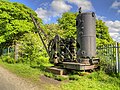
 / 53.55751; -2.35265 (Mount Sion steam crane)
Mount Sion Steam Crane.jpg
Latter half of the 19th centuryThe steam crane stands by the Manchester, Bolton and Bury Canal and served the now-demolished Mount Sion Mill. It is almost entirely in cast iron and mounted on a rectangular stone plinth. [35] II
St Andrew's Church
53°34′27″N2°20′15″W / 53.57409°N 2.33750°W / 53.57409; -2.33750 (St Andrew's Church)
St Andrews Church Radcliffe - geograph.org.uk - 397231.jpg
1875–77The church is in stone, and consists of a nave with a clerestory, north and south porches, north and south lean-to aisles, north and south transepts, a chancel with an apse, and northwest steeple. The steeple has a three-stage tower, corner pinnacles, and a spire. The west windows has five lights. [36] [37] II
Outwood Viaduct
53°33′24″N2°19′54″W / 53.55672°N 2.33164°W / 53.55672; -2.33164 (Outwood Viaduct)
Outwood Viaduct.jpg
1881The viaduct was built by the Lancashire and Yorkshire Railway to cross the valley of the River Irwell. It is now disused and has been converted into a footpath. The viaduct has five cast iron arches carried on brick pillars capped in stone, and there are brick abutments. The two pillars in the river have cutwaters. [38] [39] II
Stand United Reformed Church
53°33′04″N2°18′52″W / 53.55119°N 2.31436°W / 53.55119; -2.31436 (Stand United Reformed Church)
Stand United Reformed Church, Chapel Field, Radcliffe - geograph.org.uk - 453536.jpg
1885The church, in Decorated style, is in sandstone with slate roofs. It consists of a nave with a clerestory and porches, north and south aisles, a chancel, and a southeast steeple. The steeple has a four-stage tower a clock face, crocketed finials, and a broach spire with lucarnes. [40] [41] II
War memorial
53°33′45″N2°19′41″W / 53.56245°N 2.32802°W / 53.56245; -2.32802 (War memorial)
Radcliffe cenotaph.jpg
1922The war memorial was designed by Sydney March and is in Darley Dale sandstone. It consists of an obelisk on a cruciform pedestal on a square base of seven steps, its top being 35 feet (11 m) above street level. On the sides are bronze panels with the names of those lost in the two world wars, and on the front is a sword and a wreath. Around the base of the obelisk are three bronze winged female figures representing Liberty, Victory and Peace. The monument stands on a terrace approached by four steps flanked by walls with bronze lamp standards, and the whole is in a garden surrounded by low walls. [36] [42] II*

Related Research Articles

Grade I listed churches in Greater Manchester

Greater Manchester is a metropolitan county in North West England. It was created by the Local Government Act 1972, and consists of the metropolitan boroughs of Bolton, Bury, Oldham, Rochdale, Stockport, Tameside, Trafford, Wigan and the cities of Manchester and Salford. This is a complete list of the Grade I listed churches in the metropolitan county as recorded in the National Heritage List for England. Buildings are listed by the Secretary of State for Culture, Media and Sport on the recommendation of English Heritage. Grade I listed buildings are defined as being of "exceptional interest, sometimes considered to be internationally important"; only 2.5 per cent of listed buildings are included in this grade.

Haslingden is a town in Rossendale, Lancashire, England, and close to it are the communities of Helmshore, Ewood Bridge, and Irwell Vale. The area contains 48 buildings that are recorded in the National Heritage List for England as designated listed buildings. Of these, three are listed at Grade II*, the middle grade, and the others are at Grade II, the lowest grade. Until the coming of the Industrial Revolution the area was agricultural, and almost all the earliest listed buildings are farmhouses and farm buildings. With the arrival of industry, first came weavers' cottages and then mills, some of which are listed. As the population grew, buildings to serve the community were constructed. Listed examples of these include churches and associated structures, and a public house. The East Lancashire Railway passes through the area, and viaducts built to carry it are listed. In addition the gateway to a public park and two war memorials are listed.

Blackrod is a civil parish in the Metropolitan Borough of Bolton, Greater Manchester, England. It contains 13 listed buildings that are recorded in the National Heritage List for England. All the listed buildings are designated at Grade II, the lowest of the three grades, which is applied to "buildings of national importance and special interest". The parish is partly residential but mainly rural. The Leeds and Liverpool Canal passes through the parish and there are five listed buildings associated with it, an aqueduct and four bridges. The other listed buildings are a former country house and associated structures, farmhouses, a hotel, a church, and a war memorial.

Kearsley is a town and an unparished area in the Metropolitan Borough of Bolton, Greater Manchester, England, and it includes the area of Ringley and the village of Prestolee. The town contains 21 listed buildings that are recorded in the National Heritage List for England. Of these, one is listed at Grade II*, the middle of the three grades, and the others are at Grade II, the lowest grade. The Manchester and Bolton Railway was built through the area, and two railway bridges are listed. Also passing through the area are the Manchester Bolton and Bury Canal, which is now disused, and the River Irwell; listed buildings associated with these are bridges, an aqueduct, and milestones. The other listed buildings include a set of stocks, a house later used as a social club, two churches, a tower remaining from a demolished church, and a former spinning mill.

South Turton is an unparished area in the Metropolitan Borough of Bolton, Greater Manchester, England, and includes the settlements of Bradshaw, Bromley Cross, Harwood, Dunscar, Eagley, and Egerton, and the surrounding countryside. The area contains 28 listed buildings that are recorded in the National Heritage List for England. Of these, two are listed at Grade II*, the middle of the three grades, and the others are at Grade II, the lowest grade. The listed buildings include houses and associated structures, farmhouses, farm buildings, former cotton mills, a church and an isolated church tower, a former school, a railway station, and a war memorial.

Ramsbottom is a town in the Metropolitan Borough of Bury, Greater Manchester, England, and includes the villages of Holcombe and Summerseat and the surrounding countryside. The area is unparished, and it contains 52 listed buildings that are recorded in the National Heritage List for England. Of these, one is listed at Grade II*, the middle grade, and the others are at Grade II, the lowest grade. The area is partly agricultural, partly industrial, and partly residential. The listed buildings include farmhouses and farm buildings, private houses and associated structures, churches and items in churchyards, a hotel, public houses, a hall, an engineering works and a mill, a former railway goods shed, a monument, and a telephone kiosk.

Tottington is a town in the Metropolitan Borough of Bury, Greater Manchester, England, and the area also includes the villages of Walshaw and Greenmount and the surrounding countryside. The area is unparished, and contains 33 listed buildings that are recorded in the National Heritage List for England. Of these, two are listed at Grade II*, the middle grade, and the others are at Grade II, the lowest grade. The area is partly agricultural and partly residential, and its listed buildings include farmhouses and farm buildings, private houses and associated structures, an ancient cross, churches and associated structures, a village lock-up, and schools.

Whitefield is a town in the Metropolitan Borough of Bury, Greater Manchester, England and contains the area of Stand. It is unparished, and contains 14 listed buildings that are recorded in the National Heritage List for England. Of these, one is listed at Grade I, the highest of the three grades, and the others are at Grade II, the lowest grade. The area is mainly residential, and the listed buildings include houses and associated structures, churches and related items, and two war memorials.

Shaw and Crompton is a civil parish in the Metropolitan Borough of Oldham, Greater Manchester, England. It contains 19 listed buildings that are recorded in the National Heritage List for England. Of these, one is listed at Grade II*, the middle grade, and the others are at Grade II, the lowest grade. The parish contains the town of Shaw and Crompton and the surrounding countryside. Most of the listed buildings are farmhouses, farm buildings, houses and cottages, many of them dating from the late 18th century. The other listed buildings include an ancient cross shaft, churches, a lych gate, and a war memorial.

Chadderton is a town in the Metropolitan Borough of Oldham, Greater Manchester, England and it is unparished. It contains 19 listed buildings that are recorded in the National Heritage List for England. Of these, one is listed at Grade II*, the middle grade, and the others are at Grade II, the lowest grade. The area was rural until the coming of the Industrial Revolution, silk weaving arrived in the 18th century, and in the 19th and 20th centuries large cotton mills were built. The Rochdale Canal runs through the town, and two structures associated with it are listed, a bridge and a lock. The oldest listed buildings are farmhouses and a country house. The later buildings reflect the growing wealth of the town, and include cotton mills, churches, civic buildings, and a war memorial.

Failsworth is a town in the Metropolitan Borough of Oldham, Greater Manchester, England and it is unparished. It contains 15 listed buildings that are recorded in the National Heritage List for England. All the listed buildings are designated at Grade II, the lowest of the three grades, which is applied to "buildings of national importance and special interest". The listed buildings consist of houses, farmhouses and farm buildings, a former public house, an aqueduct, a church, a former cotton mill, and a war memorial.

Heywood is a town in the Metropolitan Borough of Rochdale, Greater Manchester, England, and it is unparished. The town and the surrounding countryside contain 18 listed buildings that are recorded in the National Heritage List for England. Of these, two are listed at Grade II*, the middle grade, and the others are at Grade II, the lowest grade. Until the coming of the Industrial Revolution the area was rural, and during the 19th century cotton mills were built. The earliest listed buildings are a house and a farmhouse with farm buildings. The later listed buildings include cotton mills and a chimney, churches and associated structures, a railway warehouse, a library, a house designed by Edgar Wood, and two war memorials.

Littleborough is a town in the Metropolitan Borough of Rochdale, Greater Manchester, England, and it is unparished. The town, its suburbs of Calderbrook and Smithy Bridge, and the surrounding countryside contain 79 listed buildings that are recorded in the National Heritage List for England. Of these, five are listed at Grade II*, the middle grade, and the others are at Grade II, the lowest grade. The area is largely rural, and most of the listed buildings are houses and associated structures, farmhouses, and farm buildings. Following the Industrial Revolution textile mills were built, some of which remain and are listed. The Rochdale Canal passes through the area and bridges and locks associated with it are listed. Also passing through the area was the Manchester and Leeds Railway, and structures associated with it are listed. The other listed buildings include churches, public houses, a former toll house, a bandstand, a drinking fountain, and two war memorials.

Milnrow is a town in the Metropolitan Borough of Rochdale, Greater Manchester, England, and it is unparished. The town, with its suburb of Newhey and the surrounding countryside, contains 49 listed buildings that are recorded in the National Heritage List for England. Of these, three are listed at Grade II*, the middle grade, and the others are at Grade II, the lowest grade. Until the Industrial Revolution the area was rural and agricultural and most of the earlier listed buildings are houses and associated structures, farmhouses and farm buildings. When the textile industry arrived, it was initially carried out in domestic premises, and many of the listed buildings of this time are houses, often with three storeys and rows of multi-light mullioned weavers' workshop windows in the upper floors. Later came mills, one of which has survived and is listed. The other listed buildings include a public house, a bridge, churches and items in churchyards, a library and a war memorial.

Rochdale is a town in the Metropolitan Borough of Rochdale, Greater Manchester, England, and it is unparished. The town and the surrounding countryside contain 137 listed buildings that are recorded in the National Heritage List for England. Of these, four are listed at Grade I, the highest of the three grades, four are at Grade II*, the middle grade, and the others are at Grade II, the lowest grade.

Wardle is a village in the Metropolitan Borough of Rochdale, Greater Manchester, England, and it is unparished. The village, together with the nearby settlement of Smallbridge and the surrounding countryside, contains 27 listed buildings that are recorded in the National Heritage List for England. All the listed buildings are designated at Grade II, the lowest of the three grades, which is applied to "buildings of national importance and special interest". The area is largely rural and agricultural, although the textile industry came to the town as a result of the Industrial Revolution. Included in the listed buildings are houses containing multi-light mullioned weavers' windows, and a mill. Most of the listed buildings are houses and associated structures, farmhouses and farm buildings. The other listed buildings include churches, a public house, a bridge and two war memorials.

Swinton and Pendlebury is a town in the City of Salford Metropolitan Borough, Greater Manchester, England. It contains 23 listed buildings that are recorded in the National Heritage List for England. Of these, one is listed at Grade I, the highest of the three grades, one is at Grade II*, the middle grade, and the others are at Grade II, the lowest grade. The listed buildings include houses, churches and items in churchyards, a public house, aqueducts, a railway viaduct, cemetery buildings, a bandstand and war memorials.

Denton is a town in Tameside, Greater Manchester, England. The town and the township of Haughton contain 18 listed buildings that are recorded in the National Heritage List for England. Of these, one is listed at Grade I, the highest of the three grades, three are at Grade II*, the middle grade, and the others are at Grade II, the lowest grade.

Manchester is a city in Northwest England. The M21 postcode area of the city includes the suburb of Chorlton-cum-Hardy. This postcode area contains 19 listed buildings that are recorded in the National Heritage List for England. Of these, one is listed at Grade II*, the middle of the three grades, and the others are at Grade II, the lowest grade. The area is mainly residential. It also contains Southern Cemetery, and a number of buildings associated with this are listed, including structures at the entrance, the chapels, a memorial, and the crematorium. Most of the other listed buildings are houses, and also included are a church, a public house and hotel, the gateway to a former church, a library, and a war memorial.

Manchester is a city in Northwest England. The M23 postcode area of the city includes parts of the suburbs of Wythenshawe and Northenden. The postcode area contains eleven listed buildings that are recorded in the National Heritage List for England. Of these, one is listed at Grade I, the highest of the three grades, two are at Grade II*, the middle grade, and the others are at Grade II, the lowest grade. The area is almost completely residential, and the listed buildings include two former manor houses and associated structures, a former farm and outbuildings, a house, a church, and a vicarage.

References

Citations

Sources