Listed buildings in Wardle, Greater Manchester

Last updated

Wardle is a village in the Metropolitan Borough of Rochdale, Greater Manchester, England, and it is unparished. The village, together with the nearby settlement of Smallbridge and the surrounding countryside, contains 27 listed buildings that are recorded in the National Heritage List for England. All the listed buildings are designated at Grade II, the lowest of the three grades, which is applied to "buildings of national importance and special interest". [1] The area is largely rural and agricultural, although the textile industry came to the town as a result of the Industrial Revolution. Included in the listed buildings are houses containing multi-light mullioned weavers' windows, and a mill. Most of the listed buildings are houses and associated structures, farmhouses and farm buildings. The other listed buildings include churches, a public house, a bridge and two war memorials.

Contents

Map all coordinates using: OpenStreetMap  
Download coordinates as: KML

Buildings

Name and locationPhotographDateNotes
Clough House
53°38′56″N2°08′25″W / 53.64902°N 2.14028°W / 53.64902; -2.14028 (Clough House)
1622A stone house on a plinth, with quoins and a stone-slate roof. There are two storeys, two bays, a rear outshut, and a right wing. The windows are mullioned with hood moulds. In the right wing is a datestone on a Tudor arched lintel. [2]
Ashbrook Hey
53°38′18″N2°07′56″W / 53.63847°N 2.13232°W / 53.63847; -2.13232 (Ashbrook Hey)
1673 (probable)A stone farmhouse with quoins and a stone-slate roof with coped gables. There are two storeys, two bays, and outbuildings at the rear. The doorway has a chamfered surround and a stone lintel. The windows are mullioned, those in the ground floor having hood moulds. [3]
Vineyard Cottages
53°39′02″N2°08′07″W / 53.65066°N 2.13516°W / 53.65066; -2.13516 (Vineyard Cottages)
1703A stone house with a stone-slate roof, later altered and extended and divided into two dwellings. It has two storeys, two bays, and a later rear range resulting in a double-depth plan. There are quoins in the left part and a porch on the left gable end. The doorway and porch have monolithic jambs and lintels and cornice hoods. The windows are mullioned, and contain 20th-century casements. [4]
The Rochdale Childrens Moorland Home
53°39′08″N2°09′35″W / 53.65210°N 2.15968°W / 53.65210; -2.15968 (The Rochdale Childrens Moorland Home)
1756Originally a farmhouse and farm buildings, later used for other purposes, it is in stone with a stone-slate roof. The former farmhouse has two storeys and three bays, a projecting porch, and mullioned windows. The former farm buildings to the left have three bays, a cart entry and a porch. [5]
Green Farmhouse, Cottage and farm buildings
53°38′05″N2°07′40″W / 53.63481°N 2.12779°W / 53.63481; -2.12779 (Green Farmhouse and Cottage)
1757The two houses, barn and farm buildings are in line, they are in stone with quoins, and have a stone-slate roof. The houses have a double-depth plan, two storeys, three bays, and a rear lean-to extension. The windows are mullioned, but some mullions have been lost. The barn to the right has a segmental-arched entry with a keystone, and to the right of that the shippon has two doors with chamfered surrounds and two semicircular openings above. In the gable is an owl hole. [6]
Globe Inn and shop
53°39′02″N2°08′03″W / 53.65042°N 2.13420°W / 53.65042; -2.13420 (Globe Inn and shop)
The Globe Inn - geograph.org.uk - 1703954.jpg
Mid to late 18th centuryThe public house and attached shop are in stone on a rendered plinth with a stone-slate roof. There are two storeys, a double-depth plan, the public house has two bays and the shop has one. There is an extension to the right and a brick lean-to at the rear. The public house has a doorway with a moulded architrave and a pediment, and the other door has a plain surround. The windows are mullioned, and there is a blocked taking-in door in the gable end. [7]
2 and 4 Lawflat
53°38′42″N2°08′06″W / 53.64487°N 2.13490°W / 53.64487; -2.13490 (2 and 4 Lawflat)
Weavers' cottages, Wardle.jpg
Late 18th centuryA pair of stone houses with a stone-slate roof, three storeys, a double-depth plan, and one bay in each house. The doorways have monolithic jambs and lintels. The windows are mullioned containing casements, those in the top floor have multiple panes replacing workshop windows. [8]
Dob Wheel Mill
53°37′54″N2°07′46″W / 53.63178°N 2.12937°W
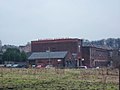
 / 53.63178; -2.12937 (Dob Wheel Mill)
Dob Wheel Mill.jpg
Late 18th centuryA textile mill to which buildings were added until the late 19th century. The earliest is a stone water mill with a slate roof. In about 1800 a brick three-storey range for hand-loom weaving was built. In 1854 the mill became steam-powered, with an engine house and a boiler house. The main range is in brick, and has two storeys and eleven bays. [9] [10]
Howarth Knowl Farmhouse
53°38′38″N2°08′04″W / 53.64383°N 2.13452°W / 53.64383; -2.13452 (Howarth Knowl Farmhouse)
Late 18th centuryA stone farmhouse with quoins and a slate roof. It has a double-depth plan, two storeys, and two bays. In the centre is a single-storey brick porch, and the windows are mullioned, including a twelve-light workshop window in the upper floor. [11]
Lower Eafield Cottages, barn and stables
53°37′48″N2°07′33″W / 53.62995°N 2.12592°W / 53.62995; -2.12592 (Lower Eafield Cottages)
Late 18th centuryThe two cottages were later combined into one house, and the barn and stable were added later at right angles to the right; they are in stone. The house has quoins, a double-depth plan, two storeys and three bays. The two doorways have square-cut lintels and three-piece jambs, and the windows are mullioned. The barn has moulded eaves corbels, and contains doorways, windows, vents with triangular heads, hay doors with pointed voussoirs, and an owl hole. In the stable are a door, two windows, and a square pitching hole. [12]
Stid Fold Farmhouse
53°39′10″N2°09′03″W / 53.65279°N 2.15078°W / 53.65279; -2.15078 (Stid Fold Farmhouse)
Late 18th centuryA stone farmhouse with quoins and a stone-slate roof. There are two storeys and two bays. On the front is a single-storey porch, and the windows are mullioned, with a former multi-light workshop window in the upper floor. [13]
Stid Fold; house at southeast
53°39′09″N2°09′02″W / 53.65243°N 2.15066°W / 53.65243; -2.15066 (Stid Fold, house at southeast)
Late 18th centuryA stone house with quoins and a stone-slate roof. There are two storeys with an attic, a double-depth plan, and one bay. The doorway has square-cut jambs and lintel, and the windows are mullioned. [14]
Wardle Fold Cottage and barn
53°39′04″N2°07′59″W / 53.65112°N 2.13314°W / 53.65112; -2.13314 (Wardle Fold Cottage)
Late 18th centuryThe house and attached barn are in stone with stone-slate roofs. The house has three storeys, a double-depth plan, and a central doorway with monolithic jambs and lintel. The windows are mullioned, those in the upper two floors are former workshop windows with eight lights. The barn to the left has rear outshuts, and a central cart entrance with long and short jambs and a timber lintel. [15]
Stid Fold; house south of Stid Fold Farmhouse
53°39′09″N2°09′06″W / 53.65248°N 2.15157°W / 53.65248; -2.15157 (Stid Fold, house south of Stid Fold Farmhouse)
Late 18th to early 19th centuryA stone house with quoins and a stone-slate roof. It has a double-depth plan, two storeys, two bays, a three-storey extension, a lean-to, and a single-storey rear extension. There is a central doorway with a monolithic surround, and most of the windows are mullioned, with two sash windows in the left gable end. [16]
20 and 22 Knowl Syke Street
53°39′03″N2°08′12″W / 53.65090°N 2.13678°W / 53.65090; -2.13678 (20 and 22 Knowl Syke Street)
c. 1800A pair of stone houses with a roof of 20th-century concrete tiles. They have a double-depth plan, three storeys, and one bay each. The doorways have monolithic jambs and lintels. The windows were mullioned, some mullions have been removed, and in the upper floors they were multi-paned workshop windows. [17]
2 and 4 Wardle Fold and
224 Ramsden Road
53°39′02″N2°08′03″W / 53.65053°N 2.13426°W / 53.65053; -2.13426 (2 and 4 Wardle Fold and 224 Ramsden Road)
c. 1800Three stone houses with a hipped roof, partly in stone-slate and partly in tiles. There are three storeys, the doorways have monolithic jambs and lintels, and there is a blocked taking-in door. The windows are mullioned, some mullions have been removed, those in the upper floors were originally multi-paned workshop windows. [18]
1 and 2 Pot House Lane
53°38′38″N2°09′11″W / 53.64375°N 2.15308°W / 53.64375; -2.15308 (1 and 2 Pot House Lane)
1809A pair of stone cottages with a stone-slate roof. They have a double-depth plan, two storeys, one bay each, and a right lean-to. The doorways have monolithic jambs and lintels, and the windows are mullioned with former workshop windows in the upper floor. [19]
Scout Headquarters
53°39′01″N2°08′06″W / 53.65041°N 2.13498°W / 53.65041; -2.13498 (Scout Headquarters)
1809Originally a chapel, later used for other purposes, it is in stone on a plinth, with quoins, a band, and a stone-slate roof. There are two storeys, and an entrance front of three bays. The doorway, windows, and an opening in the gable have semicircular heads, impost blocks, and keystones. On the left side is a gabled porch. [20] [21]
Wardle House and Whitaker Mill Farmhouse
53°39′02″N2°08′09″W / 53.65048°N 2.13579°W / 53.65048; -2.13579 (Wardle House and Whitaker Mill Farmhouse)
1815Originally a mill and a mill owner's house, later two houses. They are in stone with a stone-slate roof, three storeys and ten bays. The doorway has monolithic jambs and lintel, and in the ground floor are mullioned windows with square windows above. In the sixth bay are former loading doors. [22]
Pottery Cottage
53°38′37″N2°09′00″W / 53.64366°N 2.15000°W / 53.64366; -2.15000 (Pottery Cottage)
1825Originally a Sunday school, later a house, it is in stone with a stone-slate roof. There is one storey and three bays, with timber porches at the front and the rear. The windows have semicircular arches with impost blocks and contain casements. [23]
Bridge over River Roch
53°37′50″N2°07′49″W / 53.63063°N 2.13035°W / 53.63063; -2.13035 (Bridge over River Roch)
Early 19th centuryThe bridge carries Clegg Hall Road over the River Roch. It is in stone and consists of a single arch with lugged voussoirs, a belt, and iron cramped coping to the parapet, which is almost circular in plan, and which has square terminal piers. [24]
Great Howarth House
53°38′12″N2°08′09″W / 53.63677°N 2.13586°W / 53.63677; -2.13586 (Great Howarth House)
Early 19th centuryA stone house with a sill band, a cornice and a parapet. There are two storeys, five bays, a single-storey extension on the right, and a two-storey stone extension at the rear. The central doorway has columns, a fanlight and an open pediment. The windows are sashes, and there are semicircular windows in the gables. [25]
St John the Baptist's Church
53°38′02″N2°07′55″W / 53.63381°N 2.13194°W / 53.63381; -2.13194 (St John the Baptist's Church)
St John the Baptist Church, Smallbridge - geograph.org.uk - 467639.jpg
1834A Commissioners' church by Lewis Vulliamy, it is in stone with a slate roof. The church consists of a nave with an entrance at the west flanked by lean-to porches leading to the galleries, and a small chancel with an east vestry. At the west end are octagonal pinnacles, and on the gable is a gabled bellcote with clock faces and a finial. The nave is on a plinth, and along the sides are a continuous hood mould, lancet windows, a parapet, and corner buttresses with gablets. The east window has four lights. Inside the church are galleries, with two tiers at the west end. [26] [27]
St James' Church
53°38′59″N2°08′02″W / 53.64980°N 2.13386°W / 53.64980; -2.13386 (St James' Church)
St James Church Wardle - geograph.org.uk - 1703926.jpg
1856–58The church, designed by George Shaw in Early English style, now redundant, is in stone on a plinth, with a sill band, continuous hood moulds, and a slate roof with coped gables. It consists of a nave with a clerestory, north and south aisles, a chancel with a north organ chamber and vestry, and a southwest steeple. The steeple has a four stage tower, angle buttresses, and a broach spire with two tiers of lucarnes. [20] [28]
Methodist Church
53°39′01″N2°08′06″W / 53.65022°N 2.13489°W
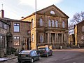
 / 53.65022; -2.13489 (Methodist Church)
Wardle Village Church - geograph.org.uk - 1703947.jpg
1874The church, in Italianate style, is in stone on a plinth, with bands and a slate roof. There are two storeys and an entrance front of four bays with flanking pilasters. In the centre is a portico with three pairs of Doric columns, an entablature and a parapet. Over this are three round-arched windows with keystones and pilasters, and above them is a gable pediment containing a semicircular window with a carved foliated surround. The outer bays contain windows with semicircular heads, those in the ground floor with entablatures. [20] [29]
Smallbridge war memorial
53°38′02″N2°07′55″W / 53.63387°N 2.13202°W / 53.63387; -2.13202 (Smallbridge war memorial)
c. 1920The war memorial is in the churchyard of St John the Baptist's Church. It is in sandstone, and consists of a cross on a square plinth on a two-stepped base. On the cross is sculpted foliate decoration and a monogram. The on the plinth are an inscription and the names of those lost in both World Wars, and on the base is another inscription. The memorial is surrounded by a low bronze railing. [30]
Wardle war memorial
53°38′19″N2°08′07″W / 53.63848°N 2.13529°W / 53.63848; -2.13529 (Wardle war memorial)
Wardle War Memorial - geograph.org.uk - 1703829.jpg
Early 1920sThe war memorial stands in a memorial garden, and is in granite and marble. It consists of a square three-stepped plinth, a pedestal in polished granite, a Doric column in grey marble, and a stylised Celtic cross in granite. There are inscriptions on the pedestal, and plaques containing the names of those lost in both World Wars. [31]

Related Research Articles

North Turton is a civil parish in Blackburn with Darwen, Lancashire, England. Included in the parish are the settlements of Edgworth, Chapeltown, Belmont, Entwistle, Quarlton, Round Barn, Turton Bottoms, and Whittlestone Head. The parish contains 65 buildings that are recorded in the National Heritage List for England as designated listed buildings. Of these, one is listed at Grade I, the highest of the three grades, five at Grade II*, the middle grade, and the others are at Grade II, the lowest grade.

Rawtenstall is a town in Rossendale, Lancashire, England. Associated with it, or nearby, are the communities of Waterfoot, Newchurch, Ewood Bridge, Lumb, Water, Crawshawbooth, Goodshaw, and Love Clough. The area contains 97 buildings that are recorded in the National Heritage List for England as designated listed buildings. Of these, eight are listed at Grade II*, the middle grade, and the others are at Grade II, the lowest grade. Until the coming of the Industrial Revolution the area was rural, and most of the oldest listed buildings are, or originated as, farmhouses, farm buildings, cottages and larger houses. A former packhorse bridge has survived, and is listed. The earliest evidence of industry is in the weavers' cottages, some of which are listed. Later came the mills; some of these have survived and are listed. The other listed buildings are those associated with the growing population and include churches and associated structures, public houses, shops, a bank, schools, a library, the gateway to the cemetery, and war memorials.

Bolton is a town in the Metropolitan Borough of Bolton, Greater Manchester, England, and its central area is unparished. The central area of the town contains over 230 listed buildings that are recorded in the National Heritage List for England. Of these, three are listed at Grade I, the highest of the three grades, 13 are at Grade II*, the middle grade, and the others are at Grade II, the lowest grade.

South Turton is an unparished area in the Metropolitan Borough of Bolton, Greater Manchester, England, and includes the settlements of Bradshaw, Bromley Cross, Harwood, Dunscar, Eagley, and Egerton, and the surrounding countryside. The area contains 28 listed buildings that are recorded in the National Heritage List for England. Of these, two are listed at Grade II*, the middle of the three grades, and the others are at Grade II, the lowest grade. The listed buildings include houses and associated structures, farmhouses, farm buildings, former cotton mills, a church and an isolated church tower, a former school, a railway station, and a war memorial.

Bury is a town in the Metropolitan Borough of Bury, Greater Manchester, England, and it is unparished. The central area of the town and the surrounding countryside contain 66 listed buildings that are recorded in the National Heritage List for England. Of these, one is listed at Grade I, the highest of the three grades, three are at Grade II*, the middle grade, and the others are at Grade II, the lowest grade.

Radcliffe is a town in the Metropolitan Borough of Bury, Greater Manchester, England, and includes the village of Ainsworth and the countryside around and between them. It is unparished, and contains 31 listed buildings that are recorded in the National Heritage List for England. Of these, two are listed at Grade I, the highest of the three grades, three are at Grade II*, the middle grade, and the others are at Grade II, the lowest grade. The listed buildings include farmhouses and farm buildings, private houses, churches and associated items, a ruined pele tower, a public house, two structures associated with the demolished Mount Sion Mill, a disused railway viaduct, and a war memorial.

Ramsbottom is a town in the Metropolitan Borough of Bury, Greater Manchester, England, and includes the villages of Holcombe and Summerseat and the surrounding countryside. The area is unparished, and it contains 52 listed buildings that are recorded in the National Heritage List for England. Of these, one is listed at Grade II*, the middle grade, and the others are at Grade II, the lowest grade. The area is partly agricultural, partly industrial, and partly residential. The listed buildings include farmhouses and farm buildings, private houses and associated structures, churches and items in churchyards, a hotel, public houses, a hall, an engineering works and a mill, a former railway goods shed, a monument, and a telephone kiosk.

Tottington is a town in the Metropolitan Borough of Bury, Greater Manchester, England, and the area also includes the villages of Walshaw and Greenmount and the surrounding countryside. The area is unparished, and contains 33 listed buildings that are recorded in the National Heritage List for England. Of these, two are listed at Grade II*, the middle grade, and the others are at Grade II, the lowest grade. The area is partly agricultural and partly residential, and its listed buildings include farmhouses and farm buildings, private houses and associated structures, an ancient cross, churches and associated structures, a village lock-up, and schools.

Shaw and Crompton is a civil parish in the Metropolitan Borough of Oldham, Greater Manchester, England. It contains 19 listed buildings that are recorded in the National Heritage List for England. Of these, one is listed at Grade II*, the middle grade, and the others are at Grade II, the lowest grade. The parish contains the town of Shaw and Crompton and the surrounding countryside. Most of the listed buildings are farmhouses, farm buildings, houses and cottages, many of them dating from the late 18th century. The other listed buildings include an ancient cross shaft, churches, a lych gate, and a war memorial.

Oldham is a town in the Metropolitan Borough of Oldham, Greater Manchester, England, and it is unparished. The town and the surrounding countryside contain 101 listed buildings that are recorded in the National Heritage List for England. Of these, four are listed at Grade II*, the middle grade, and the others are at Grade II, the lowest grade.

Chadderton is a town in the Metropolitan Borough of Oldham, Greater Manchester, England and it is unparished. It contains 19 listed buildings that are recorded in the National Heritage List for England. Of these, one is listed at Grade II*, the middle grade, and the others are at Grade II, the lowest grade. The area was rural until the coming of the Industrial Revolution, silk weaving arrived in the 18th century, and in the 19th and 20th centuries large cotton mills were built. The Rochdale Canal runs through the town, and two structures associated with it are listed, a bridge and a lock. The oldest listed buildings are farmhouses and a country house. The later buildings reflect the growing wealth of the town, and include cotton mills, churches, civic buildings, and a war memorial.

Failsworth is a town in the Metropolitan Borough of Oldham, Greater Manchester, England and it is unparished. It contains 15 listed buildings that are recorded in the National Heritage List for England. All the listed buildings are designated at Grade II, the lowest of the three grades, which is applied to "buildings of national importance and special interest". The listed buildings consist of houses, farmhouses and farm buildings, a former public house, an aqueduct, a church, a former cotton mill, and a war memorial.

Heywood is a town in the Metropolitan Borough of Rochdale, Greater Manchester, England, and it is unparished. The town and the surrounding countryside contain 18 listed buildings that are recorded in the National Heritage List for England. Of these, two are listed at Grade II*, the middle grade, and the others are at Grade II, the lowest grade. Until the coming of the Industrial Revolution the area was rural, and during the 19th century cotton mills were built. The earliest listed buildings are a house and a farmhouse with farm buildings. The later listed buildings include cotton mills and a chimney, churches and associated structures, a railway warehouse, a library, a house designed by Edgar Wood, and two war memorials.

Littleborough is a town in the Metropolitan Borough of Rochdale, Greater Manchester, England, and it is unparished. The town, its suburbs of Calderbrook and Smithy Bridge, and the surrounding countryside contain 79 listed buildings that are recorded in the National Heritage List for England. Of these, five are listed at Grade II*, the middle grade, and the others are at Grade II, the lowest grade. The area is largely rural, and most of the listed buildings are houses and associated structures, farmhouses, and farm buildings. Following the Industrial Revolution textile mills were built, some of which remain and are listed. The Rochdale Canal passes through the area and bridges and locks associated with it are listed. Also passing through the area was the Manchester and Leeds Railway, and structures associated with it are listed. The other listed buildings include churches, public houses, a former toll house, a bandstand, a drinking fountain, and two war memorials.

Middleton is a town in the Metropolitan Borough of Rochdale, Greater Manchester, England, and it is unparished. The town and the surrounding countryside contain 43 listed buildings that are recorded in the National Heritage List for England. Of these, one is listed at Grade I, the highest of the three grades, seven are at Grade II*, the middle grade, and the others are at Grade II, the lowest grade. Until the coming of the Industrial Revolution Middleton was a village, then came the industries of silk, cotton and coal. The oldest listed buildings consist of a church and vicarage, country houses, a school, a public house, and a bridge. The Rochdale Canal passes through the area, and locks and a bridge on it are listed. The later listed buildings include more churches, houses and schools, a drinking fountain, a bank, a club, a cotton mill, a park feature, and war memorials. The architect Edgar Wood lived in the town and he, sometimes with his partner Henry Sellars, designed some of the later listed buildings.

Milnrow is a town in the Metropolitan Borough of Rochdale, Greater Manchester, England, and it is unparished. The town, with its suburb of Newhey and the surrounding countryside, contains 49 listed buildings that are recorded in the National Heritage List for England. Of these, three are listed at Grade II*, the middle grade, and the others are at Grade II, the lowest grade. Until the Industrial Revolution the area was rural and agricultural and most of the earlier listed buildings are houses and associated structures, farmhouses and farm buildings. When the textile industry arrived, it was initially carried out in domestic premises, and many of the listed buildings of this time are houses, often with three storeys and rows of multi-light mullioned weavers' workshop windows in the upper floors. Later came mills, one of which has survived and is listed. The other listed buildings include a public house, a bridge, churches and items in churchyards, a library and a war memorial.

Rochdale is a town in the Metropolitan Borough of Rochdale, Greater Manchester, England, and it is unparished. The town and the surrounding countryside contain 137 listed buildings that are recorded in the National Heritage List for England. Of these, four are listed at Grade I, the highest of the three grades, four are at Grade II*, the middle grade, and the others are at Grade II, the lowest grade.

Ashton-under-Lyne is a town in the Tameside, Greater Manchester, England. The town and the countryside to the north contain 51 listed buildings that are recorded in the National Heritage List for England. Of these, one is listed at Grade I, the highest of the three grades, seven are at Grade II*, the middle grade, and the others are at Grade II, the lowest grade.

Droylsden is a town in Tameside, Greater Manchester, England. The town, together with its suburb of Littlemoss, contains 37 listed buildings that are recorded in the National Heritage List for England. Of these, three are listed at Grade II*, the middle grade, and the others are at Grade II, the lowest grade.

Stalybridge is a town in Tameside, Greater Manchester, England. The town, together with the village of Millbrook and the surrounding countryside, contains 55 listed buildings that are recorded in the National Heritage List for England. Of these, two are listed at Grade II*, the middle grade, and the others are at Grade II, the lowest grade. Initially rural and agricultural, the cotton industry came to the area in 1776. The older listed buildings are houses, farmhouses and farm buildings, and later listed buildings include structures associated with the Huddersfield Narrow Canal, mills, public houses, schools, churches, civic buildings, a bridge, and a war memorial.

References

Citations

Sources