Listed buildings in Tyldesley

Last updated

Tyldesley is a town in the Metropolitan Borough of Wigan, in Greater Manchester, England. It contains several listed buildings designated by English Heritage and included in the National Heritage List for England. Most are listed at Grade II, the lowest of the three gradings given to listed buildings and is applied to "buildings of national importance and special interest". [1]

Contents

The town's listed buildings reflect its history. Three ancient halls in the south and east, Damhouse, Chaddock and Garrett, remain from when Tyldesley was a scattered rural settlement before it developed into an industrial town after 1800. Two places of worship, Top Chapel and the parish church were built as the town's population began to increase as was the former St. George's School, built as a national school in the 1820s of which only its stone-built façade remains. Nikolaus Pevsner describes Tyldesley as "a small industrial town of parallel brick streets" [2] and considers its best building is the "handsome former Union Bank of Manchester" on Elliott Street. [3]

In the United Kingdom "listed building" refers to a building or structure designated as being of special architectural, historical, or cultural significance. They are categorised in three grades: Grade I consists of buildings of outstanding architectural or historical interest, Grade II* includes significant buildings of more than local interest and Grade II consists of buildings of special architectural or historical interest. Buildings in England are listed by the Secretary of State for Culture, Media and Sport on recommendations provided by English Heritage, which also determines the grading. [1]

Key

Map all coordinates using: OpenStreetMap  
Download coordinates as: KML  ·  GPX
GradeCriteria
Grade II*Particularly important buildings of more than special interest.
Grade IIBuildings of national importance and special interest.

Buildings and structures

Name and locationPhotographDateNotesGrade
Chaddock Hall
53°30′19″N2°26′14″W / 53.5052°N 2.4372°W / 53.5052; -2.4372 (Chaddock Hall)
17th century, (with 18th and 19th century alterations)Chaddock Hall is a brick and timber-framed house that has been rendered over. It is of two-storeys on a T-shaped plan with an 18th-century range under a slate roof. A datestone at the rear is inscribed "T.C. 1698" (Thomas Chaydock) and a lead rainwater-head is dated "S.C. 1780". [4] II
Barn at Chaddock Hall
53°30′17″N2°26′09″W / 53.5048°N 2.4359°W / 53.5048; -2.4359 (Barn at Chaddock Hall)
17th century, (with 18th and 19th century alterations)The barn at Chaddock Hall is constructed mostly in English garden wall bond brick with stone dressings and quoins on a stone plinth. It had opposed cart entries with cambered brick arches and one wall has a carved stone coat of arms. [5] II
Garden wall and stone gate piers Chaddock Hall
53°30′17″N2°26′11″W / 53.5047°N 2.4363°W / 53.5047; -2.4363 (Garden wall and stone gate piers Chaddock Hall)
17th century, (with 18th, and 19th century alterations)Chaddock Hall's garden walls are built in English garden wall bond brick and its stone gate piers to Chaddock Lane have raised panels and moulded bases, collars and capitals. The gates are made of cast-iron. [6] II
Garrett Hall
53°30′36″N2°26′31″W / 53.510°N 2.442°W / 53.510; -2.442 (St George's Church, Tyldesley)
Garrett Hall.jpeg 17th century (with 18th, 19th and 20th century alterations)The 17th-century farmhouse was formerly a manor house and home of the Tyldesley family. The two-storey, timber-framed structure was built on a T-shaped plan. It was altered in the 18th and 19th centuries when it was largely rebuilt in brick. It has a slate roof, brick chimney stacks and its walls were rendered in the 20th century. [7] [8] II
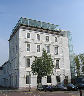
Damhouse
53°30′11″N2°27′22″W / 53.503°N 2.456°W / 53.503; -2.456 (Damhouse)
Damhouse or Astley Hall.JPG 1650Damhouse or Astley Hall was the manor house for Astley though it is inside the Tyldesley boundary. It was used as the administration block for Astley Hospital. Since 1991 Morts Astley Heritage Trust has renovated it for office use and tea room. [9] The house is built of rendered brick with stone details and a slate roof. The three-storey frontage has five unequal bays with stone mullioned windows and crosswing gables. The central three-storey porch bay has a studded oak door with Doric columns, pediment and a fanlight. The frontage is largely as built but the plaque over the door is a 20th-century replacement. The east wing dating from the early 19th century is of rendered brick and has a chapel on the first floor. [10] Restoration in 1999-2000 discovered the attic contained a "short" long gallery that had subsequently been subdivided. [11] II*
7 Sale Lane
53°30′47″N2°26′46″W / 53.513°N 2.446°W / 53.513; -2.446 (7 Sale Lane)
Sale Lane2.JPG 1685The gable-fronted house is built from hammer-dressed stone with a slate roof and a brick-built extension. It has stone mullion windows, quoins and a round window in the gable. [12] II
109 Sale Lane
53°30′50″N2°26′31″W / 53.514°N 2.442°W / 53.514; -2.442 (109 Sale Lane)
Late 17th centuryThe two-storey house is built in English garden wall bond brick with stone quoins under a slate roof which replaced the original thatch. [13] II
Tyldesley Top Chapel
53°30′47″N2°28′01″W / 53.513°N 2.467°W / 53.513; -2.467 (Tyldesley Top Chapel)
Tyldesley Top Chapel.jpg 1789The chapel was built in 1789 for the Countess of Huntingdon's Connexion in Flemish bond brick. It has a gabled front with a bellcote and two panelled doors between which on each floor are Venetian style windows with leaded glass. [14] II
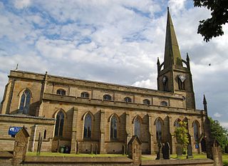
St George's Church
53°30′47″N2°28′16″W / 53.513°N 2.471°W / 53.513; -2.471 (St George's Church, Tyldesley)
St George, Tyldesley, north.jpg 1821 - 4St. George's Church is a Commissioners' Church designed by Sir Robert Smirke and consecrated in 1825. It is built in the Early English style in sandstone ashlar. It has a nave with a clerestory and north and south aisles a west tower with an octagonal spire, a chancel and vestry. [15] II
Stone built portion of St Georges School
53°30′47″N2°28′12″W / 53.513°N 2.470°W / 53.513; -2.470 (Stone built portion of St Georges School)
Old St George's School - geograph.org.uk - 690639.jpg 1829.The facade of the former St Georges School is built in dressed sandstone and has a slate roof. It comprises two storeys and seven bays in a Gothic revival style. The doorways at either end (one blocked) have pointed arches and the windows Y-tracery. A carved plaque reads, "Tyldsley Church Schools MDCCCIX rebuilt and enlarged MDCCCLVIII". [16] II
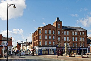
138 Elliot Street
53°30′50″N2°28′07″W / 53.5139°N 2.4686°W / 53.5139; -2.4686 (138 Elliot Street)
Elliott St built c1830.JPG 1830The two-storey house is built in red brick in Flemish bond with a Welsh slate roof. It fronts directly to the street and has two stone steps to central door flanked by fluted side pilasters and a fanlight with radial glazing bars under segmental brick arch. The bays have 16-pane sash windows under flat arches. [17] II
Drinking Fountain
53°30′51″N2°28′03″W / 53.5141°N 2.4676°W / 53.5141; -2.4676 (Drinking Fountain)
Buckley Drinking Fountain c1892.JPG 1892The drinking fountain designed in the Gothic Revival style has a square shaft on stone steps. On each face are niches one bearing the inscription: "Donated by John Buckley 1812-1892". Narrow decorative columns support gablets bearing coats of arms and a square tapering shaft takes the place of a roof. [18] II
151 Elliot Street, former bank
53°30′51″N2°28′08″W / 53.5141°N 2.4688°W / 53.5141; -2.4688 (151 Elliot Street former bank)
Former Bank, Elliott St.JPG 1900The single-storey bank, now offices, was built on a corner site to the designs of F W Morton. It is constructed in sandstone ashlar with a glazed roof. It has a three-bay front and two-bay left return facing Patchett Street. Its Classical facade has Doric order columns supporting a dentilled cornice and balustraded parapet on a plinth with pedestals. Its central doorway is under a frieze with 'BANK' in raised letters above which is the coat of arms of the Union Bank of Manchester. At either side are windows in rusticated surrounds with keystones. [19] II
Telephone Kiosk
53°30′50″N2°28′04″W / 53.5138°N 2.4677°W / 53.5138; -2.4677 (Telephone Kiosk)
Listed Telephone Box - geograph.org.uk - 1310966.jpg 1935 (designed)The red K6 telephone kiosks were designed by Sir Giles Gilbert Scott. The kiosks were manufactured in cast iron by various contractors. The kiosk has a square plan, a domed roof and the top panels are decorated with unperforated crowns. [20] II

Related Research Articles

Tyldesley Human settlement in England

Tyldesley is a town in the Metropolitan Borough of Wigan in Greater Manchester, England, but historically in Lancashire. It is north of Chat Moss near the foothills of the West Pennine Moors, 7.7 miles (12.4 km) southeast of Wigan and 8.9 miles (14.3 km) northwest of Manchester. At the United Kingdom Census 2001, the Tyldesley built-up area, excluding Shakerley, had a population of 16,142.

Listed buildings in Widnes Wikimedia list article

Widnes is an industrial town in the Borough of Halton, Cheshire, England, on the north bank of the River Mersey where it narrows at Runcorn Gap. The town contains 23 buildings that are recorded in the National Heritage List for England as designated listed buildings. Of these, 5 are classified at Grade II*, and 18 at Grade II; Widnes has no Grade I listed buildings. In the United Kingdom, the term "listed building" refers to a building or other structure officially designated as being of special architectural, historical, or cultural significance. Listed buildings are categorised in three grades: Grade I consists of buildings of outstanding architectural or historical interest; Grade II* includes particularly significant buildings of more than local interest; Grade II consists of buildings of special architectural or historical interest. Buildings in England are listed by the Secretary of State for Culture, Media and Sport on recommendations provided by English Heritage, which also determines the grading.

This is a list of Grade I listed buildings in Lancashire, England.

James Picton British architect

Sir James Allanson Picton was an English antiquary and architect who played a large part in the public life of Liverpool. He took a particular interest in the establishment of public libraries.

St Georges Church, Tyldesley Church in Greater Manchester, England

St George's Church is an Anglican parish church serving Tyldesley and Shakerley in Greater Manchester, England. It is part of Leigh deanery in the archdeaconry of Salford and the diocese of Manchester. The church, together with St Stephen's Church, Astley and St John's Church, Mosley Common is part of the united benefice of Astley, Tyldesley and Mosley Common.

Grade II listed buildings in Liverpool-L2 Wikimedia list article

Liverpool is a city and port in Merseyside, England, which contains many listed buildings. A listed building is a structure designated by English Heritage of being of architectural and/or of historical importance and, as such, is included in the National Heritage List for England. There are three grades of listing, according to the degree of importance of the structure. Grade I includes those buildings that are of "exceptional interest, sometimes considered to be internationally important"; the buildings in Grade II* are "particularly important buildings of more than special interest"; and those in Grade II are "nationally important and of special interest". Very few buildings are included in Grade I — only 2.5% of the total. Grade II* buildings represent 5.5% of the total, while the great majority, 92%, are included in Grade II.

Grade II listed buildings in Liverpool-L3 Wikimedia list article

Liverpool is a city and port in Merseyside, England, which contains many listed buildings. A listed building is a structure designated by English Heritage of being of architectural and/or of historical importance and, as such, is included in the National Heritage List for England. There are three grades of listing, according to the degree of importance of the structure. Grade I includes those buildings that are of "exceptional interest, sometimes considered to be internationally important"; the buildings in Grade II* are "particularly important buildings of more than special interest"; and those in Grade II are "nationally important and of special interest". Very few buildings are included in Grade I — only 2.5% of the total. Grade II* buildings represent 5.5% of the total, while the great majority, 92%, are included in Grade II.

Grade I listed buildings in Liverpool

There are over 2500 listed buildings in Liverpool, England. A listed building is one considered to be of special architectural, historical or cultural significance, which is protected from being demolished, extended or altered, unless special permission is granted by the relevant planning authorities. Of the listed buildings in Liverpool, 27 are classified as Grade I listed and are recognised as buildings of outstanding architectural or historic interest. The following list provides information on all the Grade I listed buildings in the city.

There are over 2500 listed buildings in Liverpool, England. A listed building is one considered to be of special architectural, historical or cultural significance, which is protected from being demolished, extended or altered, unless special permission is granted by the relevant planning authorities. Of the listed buildings in Liverpool, 105 are classified as Grade II* listed and are recognised as being particularly important with more than special architectural or historic interest. Of these, 46 are located within the L1, L2 and L3 postcodes, which cover the city centre of Liverpool. The following list provides information on all the Grade II* listed buildings within these postcodes.

There are over 2500 listed buildings in Liverpool, England. A listed building is one considered to be of special architectural, historical or cultural significance, which is protected from being demolished, extended or altered, unless special permission is granted by the relevant planning authorities. Of the listed buildings in Liverpool, at least 85 are classified as Grade II* listed and are recognised as being particularly important with more than special architectural or historic interest. The following list provides information on all the Grade II* listed buildings located in all the L postcodes outside the city centre.

Grade I listed churches in Merseyside Wikimedia list article

Merseyside is a metropolitan county in North West England. It was created by the Local Government Act 1972, and consists of the metropolitan boroughs of Knowsley, St Helens, Sefton, Wirral, and the city of Liverpool. Buildings are listed on the recommendation of English Heritage to the Secretary of State for Culture, Media and Sport, who makes the decision whether or not to list the structure. Grade I listed buildings are defined as being of "exceptional interest, sometimes considered to be internationally important"; only 2.5 per cent of listed buildings are included in this grade. This is a complete list of Grade I listed churches in the metropolitan county of Merseyside as recorded in the National Heritage List for England.

Culshaw and Sumners was a firm of English architects and surveyors who practised in Liverpool in the 19th and early 20th centuries. The work of the practice reflected the growing economic prosperity of the city during this period. Much of its work was routine and mundane, but it did produce some notable buildings, including office blocks, warehouses, domestic properties, workhouses, churches, and a hospital. The firm was established by 1839 by William Culshaw, who was joined by Henry Sumners in 1861. Following Culshaw's death in 1874, the practice was continued until 1916 by his son, Alfred.

St Josephs Roman Catholic Church, Leigh grade II listed building in the United kingdom

St Joseph's Church is an active Roman Catholic church on Chapel Street in Bedford, Leigh in Greater Manchester, England. It is in the parish of St Edmund Arrowsmith. It has been designated by English Heritage as a Grade II listed building.

Astley is a settlement in the Metropolitan Borough of Wigan in Greater Manchester, England. Originally a village, it now forms a continuous urban area with Tyldesley to the north. It lies on flat land north of Chat Moss and is crossed by the Bridgewater Canal and the A580 "East Lancashire Road". Astley contains several listed buildings designated by English Heritage and included in the National Heritage List for England. Most are listed at Grade II, the lowest of the three gradings given to listed buildings and is applied to "buildings of national importance and special interest".

There are over 9,000 Grade I listed buildings and 20,000 Grade II* listed buildings in England. This page is a list of these buildings in the unitary authority of Warrington in Cheshire, including the town of Warrington and 18 other civil parishes.

Ormskirk is a town in the West Lancashire district of Lancashire, England. The town, including the neighbouring village of Westhead and surrounding countryside, contains 68 buildings recorded in the National Heritage List for England as designated listed buildings. One is listed at Grade I, the highest of the three grades, three are at Grade II*, the middle grade, and the others are at Grade II, the lowest grade. The oldest listed buildings are a church and the remains of a priory. Many of the later listed buildings are houses and associated structures, and farmhouses and farm buildings. Other listed buildings include public houses, churches and associated structures, public buildings, buildings associated with the railway, a water tower, a drinking fountain, a water pumping house, a clock tower, a statue, war memorials, and a telephone kiosk.

Atherton is a town in the Metropolitan Borough of Wigan, Greater Manchester, England. The town and its suburbs of Howe Bridge and Hindsford contain 17 listed buildings that are recorded in the National Heritage List for England. Of these, four are listed at Grade II*, the middle of the three grades, and the others are at Grade II, the lowest grade.

Ince-in-Makerfield is a town in the Metropolitan Borough of Wigan, Greater Manchester, England. The town and the surrounding area contains eight listed buildings that are recorded in the National Heritage List for England. All the listed buildings are designated at Grade II, the lowest of the three grades, which is applied to "buildings of national importance and special interest".

References

Citations

  1. 1 2 Listed Buildings, Historic England , retrieved 6 June 2015
  2. Pevsner, Pollard & Sharples 2006, p. 595.
  3. Pevsner, Pollard & Sharples 2006, p. 596.
  4. Historic England, "Chaddock Hall (1356222)", National Heritage List for England , retrieved 16 January 2013
  5. Historic England, "Barn at Chaddock Hall (1163209)", National Heritage List for England, retrieved 16 January 2013
  6. Historic England, "Garden wall and stone gate piers Chaddock Hall (1068485)", National Heritage List for England, retrieved 16 January 2013
  7. Historic England, "Garrett Lane (north side) Garrett Hall (1163348)", National Heritage List for England, retrieved 16 January 2013
  8. Historic England, "Garrett Hall (1163348)", National Heritage List for England, retrieved 16 January 2018
  9. Dam House, English Heritage , retrieved 28 January 2013
  10. Historic England, "Administration block at Astley Hospital (formerly listed 18/7/66 as Dam House) (1163258)", National Heritage List for England, retrieved 16 January 2013
  11. Pevsner, Pollard & Sharples 2006, p. 133.
  12. Historic England, "7 Sale Lane (north side) (1068448)", National Heritage List for England, retrieved 16 January 2013
  13. Historic England, "109 Sale Lane (north side) (1163421)", National Heritage List for England, retrieved 16 January 2013
  14. Historic England, "Elliott Street (south side) Tyldesley Chapel (1356244)", National Heritage List for England, retrieved 16 January 2013
  15. Historic England, "Elliott Street (south side) Church of St George (1163277)", National Heritage List for England, retrieved 16 January 2013
  16. Historic England, "School Street (north side) Stone built portion of St Georges School (1068449)", National Heritage List for England, retrieved 16 January 2013
  17. Historic England, "138 Elliot Street This building also includes attached wing (1253332)", National Heritage List for England, retrieved 16 January 2013
  18. Historic England, "Elliott Street (north side) Drinking Fountain (1068444)", National Heritage List for England, retrieved 16 January 2013
  19. Historic England, "151 Elliot Street former bank (1068459)", National Heritage List for England, retrieved 16 January 2013
  20. Historic England, "Telephone Kiosk to north of Tyldesley Chapel (1068451)", National Heritage List for England, retrieved 16 January 2013

Bibliography