The Kivu conflict began in 2004 in the eastern Congo as an armed conflict between the military of the Democratic Republic of the Congo (FARDC) and the Hutu Power group Democratic Forces for the Liberation of Rwanda (FDLR) in the Democratic Republic of the Congo. It has broadly consisted of three phases, the third of which is an ongoing conflict. Prior to March 2009, the main combatant group against the FARDC was the National Congress for the Defence of the People (CNDP). Following the cessation of hostilities between these two forces, rebel Tutsi forces, formerly under the command of Laurent Nkunda, became the dominant opposition to the government forces.
Mpondwe is a town in the Western Region of Uganda.
Ishasha border point is a border crossing station and customs post in the Kanungu District in the Western Region of Uganda. It is inset approximately 350 metres (1,150 ft) from the Ishasha River, which is the Uganda-Democratic Republic of the Congo (DRC) border locally, and is 1.3 kilometres (0.81 mi) from the town of Ishasha, Democratic Republic of the Congo, across the river in the DRC.

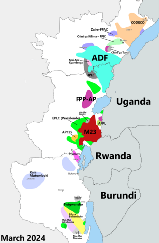
Rutshuru Territory is a territory in the North Kivu province of the eastern Democratic Republic of the Congo (DRC), with headquarters is the town of Rutshuru.
Bunagana is a town in the Western Region of Uganda. It sits across the international border from the similarly named town of Bunagana, Democratic Republic of the Congo.

Bunagana, is a small town in Rutshuru Territory, North Kivu Province, in eastern Democratic Republic of the Congo, at the border with Uganda. It served as the headquarters of the M23 rebel militia in 2013 and is, since 13 June 2022, being occupied by March 23 Movement
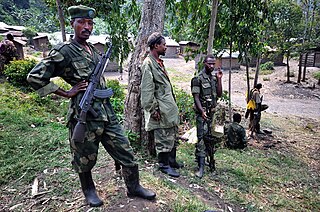
The March 23 Movement, often abbreviated as M23 and also known as the Congolese Revolutionary Army, is a rebel military group that is for the most part formed of ethnic Tutsi. Based in eastern areas of the Democratic Republic of the Congo (DRC), it operates mainly in the province of North Kivu. The M23 rebellion of 2012 to 2013 against the DRC government led to the displacement of large numbers of people. On 20 November 2012, M23 took control of Goma, a provincial capital with a population of a million people, but it was requested to evacuate it by the International Conference on the Great Lakes Region because the DRC government had finally agreed to negotiate. In late 2012, Congolese troops, along with UN troops, retook control of Goma, and M23 announced a ceasefire and said that it wanted to resume peace talks.
Mutwanga Hydroelectric Power Station, also referred to as Mutwanga Hydropower Station, is a 9.4-megawatt (12,600 hp) hydroelectric power station in the Democratic Republic of the Congo.
Rutshuru Hydroelectric Power Station, also referred to as Rutshuru Hydropower Station, is a 13.8-megawatt (18,500 hp) hydroelectric power station under construction in the Democratic Republic of the Congo. The plant was finished on December 16, 2015.
Kasindi is a town in north eastern Democratic Republic of Congo.
The Nkenda–Mpondwe–Beni High Voltage Power Line is a proposed high voltage electricity power line, connecting the high voltage substation at Nkenda, in Kasese District, in the Western Region of Uganda, to another high voltage substation at Beni, in North Kivu Province, in the Democratic Republic of the Congo.
The Mbarara–Kisangani Road is a road in Uganda and the Democratic Republic of the Congo, connecting the cities of Mbarara and Mpondwe in Uganda to Kasindi, Beni, Komanda and Kisangani in the Democratic Republic of the Congo.
Busengo is a settlement in the Western Region of Uganda. It is one of the urban centers in Kisoro District. The town lies across the international border from Busengo, Democratic Republic of the Congo.
Kasumbalesa, Zambia is a town in Zambia, that sits across the international border from the much larger town of Kasumbalesa, Democratic Republic of the Congo. It is a major crossing point for human traffic and cargo, between the two countries.
Goli–Mahagi–Bunia Road, is a road in Uganda and the Democratic Republic of the Congo, connecting the towns of Goli in Uganda with Mahagi, Djugu, Nizi and Bunia in DRCongo.
Bunagana–Rutshuru–Goma Road, is a road in Uganda and the Democratic Republic of the Congo, connecting the towns of Bunagana in Uganda with Bunagana in DRCongo. In addition the road connects these two towns to Bugani, Rutshuru, Rumangabo, Buhumba and Goma, all in DRCongo.
Kasindi–Beni–Butembo Road, is a road in the Democratic Republic of the Congo, connecting the towns of Kasindi, Beni and Butembo. The road allows interconnection between Uganda and DR Congo, facilitating trade, human interaction and enhancing joint security across the common border.
Ishasha is a town in the Democratic Republic of the Congo (DRC). The town sits across the Ishasha River, which acts as the international border, from the much smaller Ishasha Border Post, in neighboring Uganda. This town has seen much human translocations during the last decade of the 20th century and the first 20 years of the 21 century, as a result of refugees fleeing the two Congo Wars and the associated subsequent armed militia conflicts.

In late March 2022, the March 23 Movement (M23) launched an offensive in North Kivu, clashing with the Armed Forces of the Democratic Republic of the Congo (FARDC) and MONUSCO. The fighting displaced tens of thousands of civilians and caused renewed tensions between the Democratic Republic of the Congo and Rwanda, as the latter was accused of supporting the rebel offensive.
In 2022, heavy tensions broke out between the Democratic Republic of the Congo and Rwanda, which have led to several alleged attacks by Congolese and Rwandan forces on each other's territory. Rwandan forces have been caught crossing into the DRC multiple times, usually fighting alongside Congolese rebels.
