Butterfield Creek

Last updated
Butterfield Creek
Physical characteristics
Main source Cook County near Matteson, Illinois
713 ft (217 m)
41°29′49″N87°45′12″W / 41.4969444°N 87.7533333°W / 41.4969444; -87.7533333 (Butterfield Creek origin)
River mouth Confluence with Thorn Creek, Glenwood, Illinois
610 ft (190 m)
41°32′46″N87°37′26″W / 41.5461111°N 87.6238889°W / 41.5461111; -87.6238889 (Butterfield Creek mouth) Coordinates: 41°32′46″N87°37′26″W / 41.5461111°N 87.6238889°W / 41.5461111; -87.6238889 (Butterfield Creek mouth)
Length 15 mi (24 km)
Basin features
Progression Butterfield Creek → Thorn Creek → Little Calumet → Calumet → Lake Michigan → Great Lakes → Saint Lawrence Seaway → Gulf of Saint Lawrence
GNIS ID 405303
Map all coordinates using: OpenStreetMap  ·  Google Maps
Download coordinates as: KML  ·  GPX

Butterfield Creek is a 15.2-mile-long (24.5 km) [1] tributary of Thorn Creek near Chicago, Illinois, United States. [2] Via Thorn Creek, it is part of the Calumet River watershed flowing to Lake Michigan. It is at its widest around the towns of Homewood, Chicago Heights and Glenwood. The creek starts in a small marsh in Matteson and reaches its confluence with Thorn Creek in Glenwood.

Tributary stream or river that flows into a main stem river or lake

A tributary or affluent is a stream or river that flows into a larger stream or main stem river or a lake. A tributary does not flow directly into a sea or ocean. Tributaries and the main stem river drain the surrounding drainage basin of its surface water and groundwater, leading the water out into an ocean.

Thorn Creek is a 20.8-mile-long (33.5 km) tributary of the Little Calumet River that travels through Will and Cook counties in northeastern Illinois just south of Chicago. It starts in the high land of the Valparaiso Moraine before dropping 200 feet (60 m) to the lower elevations of the Little Calumet River valley. Along its path it has cut many deep ravines and valleys. It is usually quite narrow, though the width of the river varies. Under 26th Street in Chicago Heights, a dam built in 1928 forms Sauk Lake, but just north of the street it is just a few feet across. This dam creates an accumulation of several feet of silt in Sauk Lake and is being considered for Notching in 2016 by the Corps of Engineers. The intent is to 'improve stream habitat'. The impact upon Ground Water Recharge, mitigation of Thorn Creek's 'flashiness' and future recreational activities are also concerns of Water-Shed Stakeholders.

Chicago City in Illinois, United States

Chicago, officially the City of Chicago, is the most populous city in Illinois and the third most populous city in the United States. With an estimated population of 2,716,450 (2017), it is the most populous city in the Midwestern United States. Chicago is the county seat of Cook County, the second most populous county in the United States, and the principal city of the Chicago metropolitan area, which is often referred to as "Chicagoland." The Chicago metropolitan area, at nearly 10 million people, is the third-largest in the United States; the fourth largest in North America ; and the third largest metropolitan area in the world by land area.

Butterfield Creek is severely degraded by a variety of pollutants including heavy metals, DDT, bacteria, and sediment which limits the stream's habitat potential. Several sewage treatment plants discharge into the stream. Riparian habitat is also severely disturbed by a combination of extreme discharges of stormwater and development. The stream has been the focus of many efforts to restore and protect water quality undertaken by a variety of governmental, non-governmental and private entities.

DDT Organochloride known for its insecticidal properties

Dichlorodiphenyltrichloroethane, commonly known as DDT, is a colorless, tasteless, and almost odorless crystalline chemical compound, an organochlorine, originally developed as an insecticide, and ultimately becoming infamous for its environmental impacts. It was first synthesized in 1874 by the Austrian chemist Othmar Zeidler. DDT's insecticidal action was discovered by the Swiss chemist Paul Hermann Müller in 1939. DDT was used in the second half of World War II to control malaria and typhus among civilians and troops. Müller was awarded the Nobel Prize in Physiology or Medicine "for his discovery of the high efficiency of DDT as a contact poison against several arthropods" in 1948.

Butterfield Creek flows through several country club golf courses in Olympia Fields, Flossmoor, and Homewood; management of these tracts has degraded in-stream and riparian conditions necessary for wildlife movement.

Golf course series of holes designed for the game of golf

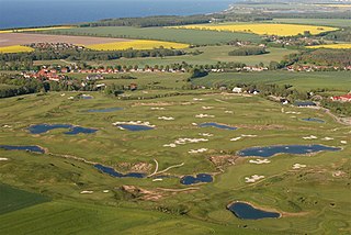
A golf course is the grounds where the game of golf is played. It comprises a series of holes, each consisting of a teeing ground, a fairway, the rough and other hazards, and a green with a flagstick ("pin") and hole ("cup"). A standard round of golf consists of 18 holes. Most courses contain 18 holes; some share fairways or greens, and a subset has nine holes, played twice per round. Par-3 courses consist of nine or 18 holes all of which have a par of three strokes.

Olympia Fields, Illinois Village in Illinois, United States

Olympia Fields is a village in Cook County, Illinois, United States. The population was 4,988 at the 2010 census. The municipality grew up around the prestigious Olympia Fields Country Club, originally established in 1915.

Flossmoor, Illinois Village in Illinois, United States

Flossmoor is a village in Cook County, Illinois, United States. The population was 9,464 at the 2010 census.

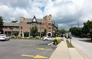
The Butterfield Creek corridor continues to provide some habitat connectivity between upland headwaters and the complex of Cook County Forest Preserve District properties along Thorn Creek. The Town of Homewood has created a run/walk trail along portions of lower Butterfield Creek.

Related Research Articles

Virgin River river in Nevada, United States

The Virgin River is a tributary of the Colorado River in the U.S. states of Utah, Nevada, and Arizona. The river is about 162 miles (261 km) long. It was designated Utah's first wild and scenic river in 2009, during the centennial celebration of Zion National Park.

Beaver River (Pennsylvania) tributary of the Ohio River in Western Pennsylvania in the United States

The Beaver River is a tributary of the Ohio River in Western Pennsylvania in the United States with a length of approximately 21 mi (34 km). It flows through a historically important coal-producing region north of Pittsburgh. The Beaver River is formed in Lawrence County by the confluence of the Mahoning and Shenango rivers in the Mahoningtown neighborhood of New Castle. It flows generally south, past West Pittsburg and Homewood. It receives Connoquenessing Creek west of Ellwood City and flows past Beaver Falls and New Brighton. It joins the Ohio at Bridgewater and Rochester at the downstream end of a sharp bend in the Ohio approximately 20 mi (32 km) northwest of Pittsburgh. In the lower reaches near the Ohio River, the Beaver cuts through a gorge of underlying sandstone. The river is roughly parallel to the border with the state of Ohio, with both Interstate 376 and Pennsylvania Route 18 running parallel to the river itself.

Red Clay Creek is a 13.6-mile-long (21.9 km) tributary of White Clay Creek, running through southeastern Pennsylvania and northern Delaware in the United States. As of 2000, portions of the creek are under wildlife habitat protection.

Teton River (Idaho) river in the United States of America

The Teton River is an 64-mile-long (103 km) tributary of the Henrys Fork of the Snake River in southeastern Idaho in the United States. It drains through the Teton Valley along the west side of the Teton Range along the Idaho-Wyoming border at the eastern end of the Snake River Plain. Its location along the western flank of the Tetons provides the river with more rainfall than many other rivers of the region.

Bank (geography) in geography, area between high and low tide marks

In geography, the word bank generally refers to the land alongside a body of water. Different structures are referred to as banks in different fields of geography, as follows.

Redwood Creek (Humboldt County) river in the United States of America

Redwood Creek is a 61.8-mile (99.5 km) river in Humboldt County, California. The river's headwaters are in the Coast Range at about 5,000 feet (1,500 m) and it flows roughly northwest until it empties into the Pacific Ocean near the small town of Orick, the only development in the 280-square-mile (730 km2)-watershed.

Mill Creek (San Bernardino County) tributary of the Santa Ana River in San Bernardino County, California, USA

Mill Creek is a 17.8-mile-long (28.6 km) stream, originating in the San Bernardino Mountains, in San Bernardino County, California. It is a major tributary of the Santa Ana River. Their confluence occurs just downstream of the upper Santa Ana Canyon mouth. Part of the upper creek flows through San Bernardino National Forest, with the headwaters, being in the San Gorgonio Wilderness.

Deer Creek (Tehama County, California) tributary of the Sacramento River

Deer Creek is a 60-mile-long (97 km) southwestward-flowing stream in Northern California that flows through Tehama County, California. It is an eastside tributary of the Sacramento River. As one of only three remaining Sacramento River tributaries supporting native runs of the genetically distinct Central Valley spring-run Chinook salmon, it is a stronghold for this state and federally endangered fish as well as other salmonids.

Sonoma Creek stream in California

Sonoma Creek is a 33.4-mile-long (53.8 km) stream in northern California. It is one of two principal drainages of southern Sonoma County, California, with headwaters rising in the rugged hills of Sugarloaf Ridge State Park and discharging to San Pablo Bay, the northern arm of San Francisco Bay. The watershed drained by Sonoma Creek is roughly equivalent to the wine region of Sonoma Valley, an area of about 170 square miles (440 km2). The State of California has designated the Sonoma Creek watershed as a “Critical Coastal Water Resource”. To the east of this generally rectangular watershed is the Napa River watershed, and to the west are the Petaluma River and Tolay Creek watersheds.

Fossil Creek river in the United States of America

Fossil Creek is a perennial stream near the community of Strawberry in the U.S. state of Arizona. A tributary of the Verde River, Fossil Creek flows from its headwaters on the Mogollon Rim to meet the larger stream near the former Childs Power Plant.

Copeland Creek stream in Sonoma County, California

Copeland Creek is a 9.0-mile-long (14.5 km) perennial stream that rises on Sonoma Mountain in Sonoma County, California.

Graham Creek is a 2.9-mile-long (4.7 km) perennial stream in Sonoma County, California, tributary to Sonoma Creek. Graham Creek rises in the northern Sonoma Mountains and flows generally northeasterly down the northeastern flank of Sonoma Mountain. Historically this watercourse was called Wild Water Creek, a name used in the time of author Jack London, some of whose work was inspired by the stream. Steelhead, Oncorhynchus mykiss, have historically entered Graham Creek via Sonoma Creek for spawning. Stream surveys conducted from 1966 to 1986 indicated significant, but declining populations of anadromous fish. The spawning habitat of Graham Creek is considered medium to high value, with both winter and summer sheltering characteristics.

Sycamore Creek is a perennial stream in Contra Costa County, in the U.S. state of California. There is an associated trail along a portion of the creek, which trail has been developed by the city of Danville, California and the East Bay Municipal Utility District.

Pilarcitos Creek is a 13.5-mile-long (21.7 km) coastal stream in San Mateo County, California, United States, that rises on the western slopes of the Santa Cruz Mountains and descends through Pilarcitos Canyon to discharge into the Pacific Ocean Half Moon Bay State Beach.

San Juan Creek

San Juan Creek, also called the San Juan River, is a 29-mile (47 km) long stream in Orange County, California draining a watershed of 133.9 square miles (347 km2). Its mainstem begins in the southern Santa Ana Mountains in the Cleveland National Forest. It winds west and south through San Juan Canyon, and is joined by Arroyo Trabuco as it passes through San Juan Capistrano. It flows into the Pacific Ocean at Doheny State Beach. San Juan Canyon provides a major part of the route for California State Route 74.

Clearwater River (Idaho) river in the United States of America

The Clearwater River is in the northwestern United States, in north central Idaho. Its length is 74.8 miles (120.4 km), it flows westward from the Bitterroot Mountains along the Idaho-Montana border, and joins the Snake River at Lewiston. In October 1805, the Lewis and Clark Expedition descended the Clearwater River in dugout canoes, putting in at "Canoe Camp," five miles (8 km) downstream from Orofino; they reached the Columbia Bar and the Pacific Ocean about six weeks later.

Normans Kill river in the United States of America

The Normans Kill is a 45.4-mile-long (73.1 km) creek in New York's Capital District located in Schenectady and Albany counties. It flows southeasterly from its source in the town of Duanesburg near Delanson to its mouth at the Hudson River in the town of Bethlehem. In the town of Guilderland, the stream is dammed to create the Watervliet Reservoir, a drinking water source for the city of Watervliet and the Town of Guilderland. A one megawatt hydrolectric plant at the dam provides power to pump water to the filtration plant.

Harshaw Creek river in the United States of America

Harshaw Creek is a stream in the Patagonia Mountains of Santa Cruz County, Arizona, named after David Tecumseh Harshaw, who settled along its banks in the mid-1870s. It is approximately 15 miles (24 km) long and flows in a north to northwesterly direction toward the community of Patagonia, where it joins with Sonoita Creek.

Leach Creek is a tributary of Leggetts Creek in Lackawanna County, Pennsylvania, in the United States. It is approximately 1.9 miles (3.1 km) long and flows through Scranton. The watershed of the creek has an area of 2.55 square miles (6.6 km2). The creek loses substantial amounts of water to underground mine pools. The creek is in the Coal Region and has been channelized and/or culvertized in some reaches. It flows alongside Pennsylvania Route 307 for a substantial part of its length. The creek has a riparian buffer in its upper and middle reaches, but various invasive plants grow along its banks in its lower reaches.

References

  1. U.S. Geological Survey. National Hydrography Dataset high-resolution flowline data. The National Map Archived 2012-04-05 at WebCite , accessed May 19, 2011
  2. U.S. Geological Survey Geographic Names Information System: Butterfield Creek