
Richard Totten Button is an American former figure skater and skating analyst. He was a two-time Olympic champion and five-time consecutive World champion (1948–1952). He was also the only non-European man to have become European champion. Button is credited as having been the first skater to successfully land the double Axel jump in competition in 1948, as well as the first triple jump of any kind – a triple loop – in 1952. He also invented the flying camel spin, which was originally known as the "Button camel". He "brought increased athleticism" to figure skating in the years following World War II.

Psycho Pinball is a 1994 pinball video game published and developed by Codemasters, released for the Mega Drive in the United Kingdom, and MS-DOS in the United States and Europe.

The Mystery of the Flying Express is Volume 20 in the original The Hardy Boys Mystery Stories published by Grosset & Dunlap.

Boott Spur is a minor peak located in Coos County, New Hampshire, United States. The mountain is named after Francis Boott (1792–1863), and is part of the Presidential Range of the White Mountains. Boott Spur stands on the shoulder of Mount Washington, above the south side of the headwall of Tuckerman Ravine.

Eagle Peak is located in the Warner Mountains in Modoc County, California, United States. The area is protected in the South Warner Wilderness on the Modoc National Forest. The summit is the highest point in the Warner Mountains and Modoc County. Much of the precipitation that falls on Eagle Peak is snow due to the high elevation of the mountain.

Freel Peak is a mountain located in the Carson Range, a spur of the Sierra Nevada, near Lake Tahoe in California.

The BAR 005 was the car with which the British American Racing Formula One team competed in the 2003 Formula One season. The car was driven by Jacques Villeneuve and Jenson Button, the former being replaced by test driver Takuma Sato for the last race of the season. The team's test driver was Anthony Davidson along with Sato. The BAR 005 was officially launched at Circuit de Catalunya, Spain on 14 January.

The Samsung Impression is a slider-style mobile phone manufactured by Samsung Electronics. First announced on March 30, 2009, it was released on April 7, 2009. It was the first phone manufactured for the United States to have an AMOLED touch-screen.

Southford Falls State Park is a public recreation area covering 126 acres (51 ha) in the towns of Oxford and Southbury, Connecticut. The state park offers fishing, hiking, waterfalls, a fire tower, and a covered bridge over Eight Mile Brook. It is managed by the Connecticut Department of Energy and Environmental Protection.

Panic Button is a 1964 low-budget Italian-produced comedy film starring, Maurice Chevalier, Eleanor Parker, Jayne Mansfield, and Mike Connors. Filmed in the summer of 1962, in Italy, and released nearly two years later, the film tells the story of how a washed-up actor (Chevalier) and a buxom unknown (Mansfield) are chosen to co-star in a television production of Romeo and Juliet. The picture is known for being one of several foreign films Mansfield was forced to make after her contract was dropped from 20th Century Fox in 1962.
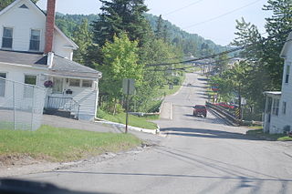
Beecher Falls is a census-designated place in the town of Canaan, Essex County, Vermont, United States. Beecher Falls is located on the Connecticut River across from Stewartstown, New Hampshire, in the northeast corner of Vermont. Its population was 177 as of the 2010 census.

Hyndman Peak, at an elevation of 12,012 feet (3,661 m) above sea level, is the ninth highest peak in Idaho and the highest point in the Pioneer Mountains, Sawtooth National Forest, and Blaine County. Hyndman Peak is located on the border of Custer and Blaine counties. The towns of Hailey, Ketchum, and Sun Valley are west of the peak.

The Huawei IDEOS U8150 is an Android smartphone manufactured by Huawei.
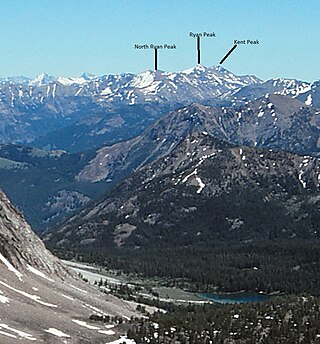
Ryan Peak, at 11,714 feet (3,570 m) above sea level is the highest peak in the Boulder Mountains of Idaho. Located in Custer County, Ryan Peak is about 0.5 miles (800 m) north of the Blaine County border. The peak is also on the border of Sawtooth National Recreation Area and Salmon-Challis National Forest and partially within the Hemingway–Boulders Wilderness.

A lady's navel or woman's navel is a type of sweet pastry from Turkey. They are made from balls of choux pastry which are given a dimple, deep-fried and then soaked in syrup. Although the original form of the pastry apparently bore little resemblance to a woman's navel other than the depressed point or dimple in the center, many modern versions, especially ones created in the United States and United Kingdom since the 1990s, have been intentionally designed to resemble a woman's belly button. Features included for this visual and sensory effect include placing dark-colored powder, often cocoa powder, inside the dimple to resemble dirt or gunk inside the belly button, moulding the interior of the dimple itself to somewhat resemble lumps of umbilical cord tissue, and even inserting either edible or inedible decorations around the dimple to represent navel piercing jewelry.

Flagstone Peak is located in the Wind River Range in the U.S. state of Wyoming. The peak is the 12th highest peak in Wyoming. The summit is located on the Continental Divide and is in both Shoshone and Bridger-Teton National Forests. The Flagstone Peak-Southeast Peak lies .25 mi (0.40 km) to the southeast.
Shale Mountain is located in the northern Wind River Range in the U.S. state of Wyoming. Shale Mountain straddles the Continental Divide and is in both Bridger-Teton and Shoshone National Forests. Shale Mountain is 5 mi (8.0 km) north of Downs Mountain.
Torrey Peak is located in the northern Wind River Range in the U.S. state of Wyoming. Torrey Peak is in Shoshone National Forest near the southern end of Upper Ross Lake.

Atlantic Peak is located in the southern Wind River Range in the U.S. state of Wyoming. Atlantic Peak sits along the Continental Divide, less than 1 mi (1.6 km) southeast of West Atlantic Peak.
Button Creek is a river in Madison County in New York. It flows into Unadilla River south of Leonardsville. Button Falls is located about 1 mile (1.6 km) upstream from the mouth.

