
The Low Desert is a common name for any desert in California that is under 2,000 feet in altitude. These areas include, but are not exclusive to, the Colorado Desert and Yuha Desert branches of the Sonoran Desert, in the far southeasternmost portion of Southern California. The Low Desert is distinguished in biogeography from the adjacent northern High Desert or Mojave Desert by latitude, elevation, animal life, climate, and native plant communities.

The protected areas of the United States are managed by an array of different federal, state, tribal and local level authorities and receive widely varying levels of protection. Some areas are managed as wilderness, while others are operated with acceptable commercial exploitation. As of 2022, the 42,826 protected areas covered 1,235,486 km2 (477,024 sq mi), or 13 percent of the land area of the United States. This is also one-tenth of the protected land area of the world. The U.S. also had a total of 871 National Marine Protected Areas, covering an additional 1,240,000 sq mi (3,200,000 km2), or 26 percent of the total marine area of the United States.

Colorado Desert is a part of the larger Sonoran Desert located in California, United States, and Baja California, Mexico. It encompasses approximately 7 million acres, including the heavily irrigated Coachella, Imperial and Mexicali valleys. It is home to many unique flora and fauna.

The Chocolate Mountains of California are located in Imperial and Riverside counties in the Colorado Desert of Southern California. The mountains stretch more than 60 miles (100 km) in a northwest to southeast direction, and are located east of the Salton Sea and south and west of the Chuckwalla Mountains and the Colorado River. To the northwest lie the Orocopia Mountains.

The Little Picacho Wilderness is a 38,214-acre (15,465 ha) wilderness area under the jurisdiction of the Bureau of Land Management. The wilderness is found in a southeast extension of the Chocolate Mountains adjacent to the Colorado River, in the southeastern part of California. It should not be confused with the Picacho Peak Wilderness which is located to the northeast.

The Chemehuevi Mountains are a mountain range that are found at the southeast border of San Bernardino County in southeastern California and are adjacent the Colorado River. Located south of Needles, California and northwest of the Whipple Mountains, the mountains are oriented in a north–south direction, and stretch for approximately 15 miles (24 km) in length.
The Palen Mountains are located in the southern Mojave Desert – northern Colorado Desert in eastern Riverside County, California, US. The range lies southeast of the Coxcomb Mountains, and northeast of the Chuckwalla Mountains near Interstate 10. The mountains lie in a southwest-northeasterly direction and are approximately 15 miles long and nine miles wide at their widest point.

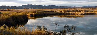
The Turtle Mountains, are located in northeastern San Bernardino County, in the southeastern part of California. The colorful Turtle Mountains vary from deep reds, browns, tans and grays, to black. The area has numerous springs and seeps. The Turtle Mountains are also a National Natural Landmark, with two mountain sections of entirely different composition.

The Fish Creek Mountains Wilderness is located about 25 miles west of Brawley, California, and southeast of the Vallecito Mountains in the United States. The wilderness is located in the Fish Creek Mountains region in the northern part of the Carrizo Impact Area, which is closed to the public.

The Trigo Mountains are a north-south trending mountain range in La Paz County, Arizona, bordering the Colorado River on the east in the Lower Colorado River Valley. The range lies north of the Colorado River as it turns east, north of Martinez Lake and the Imperial Reservoir. The Trigo Mountains are on a north-south stretch of the Colorado River, and form the eastern perimeter of the Imperial National Wildlife Refuge.

The Kofa Mountains of Yuma and La Paz counties in Arizona is the central mountain range of the Kofa National Wildlife Refuge. The range lies about 60 miles northeast of Yuma in the southwestern part of the state. Kofa Wilderness takes up 547,719 acres of the refuge, making it the second largest wilderness area in Arizona. The equally extensive Castle Dome Mountains comprise the southern refuge border; the western end of the Tank Mountains are in the southeast of the wildlife refuge, and the New Water Wilderness in the New Water Mountains ends the extension of the Kofa National Wildlife Refuge to the north. Scenic "King Valley" is south of the Kofa Mountains between the Castle Dome Mountains.

The Bill Williams River is a 46.3-mile-long (74.5 km) river in west-central Arizona where it, along with one of its tributaries, the Santa Maria River, form the boundary between Mohave County to the north and La Paz County to the south. It is a major drainage westwards into the Colorado River of the Lower Colorado River Valley south of Hoover Dam and Lake Mead, and the drainage basin covers portions of northwest, and west-central Arizona. The equivalent drainage system paralleling the east–west lower reaches of the Bill Williams is the Gila River, which flows east-to-west across central Arizona, joining the Colorado River in the southwest at Yuma. The confluence of the Bill Williams River with the Colorado is north of Parker, and south of Lake Havasu City.

The Coyote Mountains are a small mountain range in San Diego and Imperial County in Southern California. The Coyotes form a narrow ESE trending 2 mi (3.2 km) wide range with a length of about 12 mi (19 km). The southeast end turns and forms a 2 mi (3.2 km) north trending "hook". The highest point is Carrizo Mountain on the northeast end with an elevation of 2,408 feet (734 m). Mine Peak at the northwest end of the range has an elevation of 1,850 ft (560 m). Coyote Wash along Interstate 8 along the southeast margin of the range is 100 to 300 feet in elevation. Plaster City lies in the Yuha Desert about 5.5 mi (8.9 km) east of the east end of the range.
The Palo Verde Mountains are a mountain range in northeastern Imperial County, California. They are located along the west side of the Colorado River in the Lower Colorado River Valley and Colorado Desert. Palo Verde Peak, which rises to about 1,800 feet in the southern portion, is the highest point in the area. Thumb Peak stands to the north. Clapp Spring, a palm oasis, is located east of Thumb Peak. Clapp Spring is the only permanent water source in the area for wildlife species.
The Indian Pass Wilderness is 32,418-acre (13,119 ha) wilderness area under the administered by the Bureau of Land Management. The reserve is located in the very southeastern part of the Chocolate Mountains, in the southeastern part of California, just to the west of the Colorado River in the Lower Colorado River Valley. It adjoins the Picacho Peak Wilderness to the south, and the Imperial National Wildlife Refuge to the east.

The Santa Rosa Wilderness is a 72,259-acre (292.42 km2) wilderness area in Southern California, in the Santa Rosa Mountains of Riverside and San Diego counties, California. It is in the Colorado Desert section of the Sonoran Desert, above the Coachella Valley and Lower Colorado River Valley regions in a Peninsular Range, between La Quinta to the north and Anza Borrego Desert State Park to the south. The United States Congress established the wilderness in 1984 with the passage of the California Wilderness Act, managed by both the US Forest Service and the Bureau of Land Management. In 2009, the Omnibus Public Land Management Act was signed into law which added more than 2,000 acres (8.1 km2). Most of the Santa Rosa Wilderness is within the Santa Rosa and San Jacinto Mountains National Monument.
The Imperial National Wildlife Refuge protects wildlife habitat along 30 miles (50 km) of the lower Colorado River in Arizona and California, including the last un-channeled section before the river enters Mexico. The Imperial Refuge Wilderness, a federally designated, 15,056-acre (60.93 km2), wilderness area is protected within the refuge. It also surrounds the Picacho State Recreation Area. This section of the Colorado River is popular for boating, hiking, fishing, camping, exploring old mining camps and wildlife watching.

The Altar Valley is a 45-mile (72 km) long north–south valley, trending slightly northeast from Sasabe, Arizona on the Mexico border to the Avra Valley west of the Tucson Mountains. It is delimited by Arizona State Route 86, from east-to-west on the north separating it from the Avra Valley which then trends northwesterly, merging into the plains and drainage of the Santa Cruz River.
The Rawhide Mountains are a mountain range of western Arizona, in the southwest of Mohave County. It is part of a block of mountain ranges on the north of an insular region called the Maria fold and thrust belt, containing mountain ranges, valleys, and plains. The Rawhide Mountains border the much smaller Artillery Mountains southeast, bordering on Alamo Lake State Park and the south-flowing Big Sandy River.

