Byumba

Last updated • a couple of secsFrom Wikipedia, The Free Encyclopedia
Byumba
City and sector
Diocese.jpg
The Roman Catholic Diocese of Byumba
Rwanda adm location map.svg
Red pog.svg
Byumba
Location in Rwanda
Coordinates: 1°34′34″S30°04′03″E / 1.57611°S 30.06750°E / -1.57611; 30.06750
Country Flag of Rwanda.svg Rwanda
Admin. Province Northern Province
District Gicumbi
Area
   City and sector 48.25 km2 (18.63 sq mi)
Elevation
2,237 m (7,339 ft)
Population
 (2022 census) [1]
   City and sector 43,134
  Density890/km2 (2,300/sq mi)
   Urban
19,270
Climate Cwb

Byumba is a city and sector in northern Rwanda and the capital of Gicumbi District. It is home to an SOS Children's Village. The city lies about 60 kilometres (37 mi), north of the capital Kigali. [2] This location lies approximately 30 kilometres (19 mi), south of the International border with Uganda at Gatuna. [3]

Contents

Population

As of 2012, the human population in Byumba was estimated at 75,463.

Economic activity

Banque Populaire du Rwanda (BPR), maintains a branch in Byumba.

Education

Climate

Climate data for Byumba (1991–2020)
MonthJanFebMarAprMayJunJulAugSepOctNovDecYear
Record high °C (°F)28.4
(83.1)
27.4
(81.3)
27.7
(81.9)
25.0
(77.0)
25.3
(77.5)
24.9
(76.8)
25.0
(77.0)
26.0
(78.8)
26.1
(79.0)
27.2
(81.0)
24.8
(76.6)
25.9
(78.6)
28.4
(83.1)
Mean daily maximum °C (°F)21.8
(71.2)
22.1
(71.8)
21.7
(71.1)
20.9
(69.6)
20.6
(69.1)
20.9
(69.6)
21.6
(70.9)
22.3
(72.1)
22.4
(72.3)
21.6
(70.9)
20.8
(69.4)
21.2
(70.2)
21.5
(70.7)
Daily mean °C (°F)17.1
(62.8)
17.2
(63.0)
17.0
(62.6)
16.5
(61.7)
16.2
(61.2)
16.3
(61.3)
16.7
(62.1)
17.2
(63.0)
17.3
(63.1)
16.8
(62.2)
16.3
(61.3)
16.6
(61.9)
16.8
(62.2)
Mean daily minimum °C (°F)12.4
(54.3)
12.3
(54.1)
12.3
(54.1)
12.0
(53.6)
11.9
(53.4)
11.7
(53.1)
11.9
(53.4)
12.2
(54.0)
12.2
(54.0)
12.0
(53.6)
11.9
(53.4)
12.1
(53.8)
12.1
(53.8)
Record low °C (°F)10.0
(50.0)
9.2
(48.6)
9.0
(48.2)
9.3
(48.7)
8.2
(46.8)
7.5
(45.5)
7.5
(45.5)
8.1
(46.6)
8.8
(47.8)
9.1
(48.4)
9.2
(48.6)
9.5
(49.1)
7.5
(45.5)
Average precipitation mm (inches)63.6
(2.50)
85.5
(3.37)
156.7
(6.17)
175.1
(6.89)
122.2
(4.81)
29.7
(1.17)
10.8
(0.43)
54.4
(2.14)
112.4
(4.43)
132.8
(5.23)
132.3
(5.21)
72.3
(2.85)
1,147.8
(45.19)
Average precipitation days (≥ 1.0 mm)6.68.415.117.312.83.31.25.012.415.817.010.6125.4
Source: NOAA [4]

Notable people

Related Research Articles

<span class="mw-page-title-main">Transport in Rwanda</span>

The transport system in Rwanda centres primarily around the road network. Paved roads lie between the capital, Kigali, and most other major cities and towns in the country. Rwanda is also linked by road with other countries in the African Great Lakes, via which the majority of the country's imports and exports are made.

<span class="mw-page-title-main">Kigali</span> Capital and the largest city of Rwanda

Kigali is the capital and largest city of Rwanda. It is near the nation's geographic centre in a region of rolling hills, with a series of valleys and ridges joined by steep slopes. As a primate city, Kigali is a relatively new city. It has been Rwanda's economic, cultural, and transport hub since it was founded as an administrative outpost in 1907, and became the capital of the country at independence in 1962, shifting focus away from Huye.

<span class="mw-page-title-main">Kibuye, Rwanda</span> City in Western Province, Rwanda

Kibuye is a city in Karongi District, and the headquarters of the Western Province in Rwanda.

<span class="mw-page-title-main">Kibungo</span> Town and sector in Eastern Province, Rwanda

Kibungo is a town and sector in the Republic of Rwanda. It is the political, administrative and commercial capital of Ngoma District. In 1998, Kibungo became the site of at least four of Rwanda's last 22 executions. All of the convicts were executed for crimes related to the 1994 genocide.

<span class="mw-page-title-main">Muhanga</span> City in Southern Province, Rwanda

Muhanga is a city in Rwanda, in the Muhanga District, in Southern Province. The city is situated 5,945 feet (1,812 m) above sea level.

Nyagatare is a town in the North East of Rwanda. With a population of more than 100,000, it is one of the most populous settlements in the Eastern Province along with Rwamagana and Kibungo.

<span class="mw-page-title-main">Gicumbi District</span> District in Rwanda

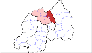
Gicumbi is a district (akarere) in Northern Province, Rwanda. Its capital is Byumba, which is also the provincial capital.

<span class="mw-page-title-main">Ngororero District</span> District in Rwanda

Ngororero District is a district (akarere) in Western Province, Rwanda. Its capital is the town of Ngororero.

Ngororero is a sector and town in Rwanda.

<span class="mw-page-title-main">I&M Bank Rwanda</span> Rwandan bank

I&M Bank Rwanda Plc., is a commercial bank in Rwanda that is licensed by the National central Bank of Rwanda(central bank). It is the second largest bank in Rwanda.

<span class="mw-page-title-main">Nyamata</span> Town in Rwanda

Nyamata is a town and sector in the Bugesera District, southeastern Rwanda. Nyamata literally means 'place of milk' from the two Kinyarwanda words nya- 'of' and amata 'milk'. It is the location of the Nyamata Genocide Memorial, commemorating the Rwandan genocide of 1994.

Bugarama is a town in western Rwanda.

Katuna is a town in the Kabale District of Uganda at the border with Rwanda. The town is also called "Gatuna" in the Kinyarwanda language.

Gatuna is a small settlement in Cyumba Sector in northern Rwanda. It is located at the northern border adjacent to the town of Katuna, in neighboring Uganda.

Kabarore is a town and sector in Rwanda. It is the headquarters of Gatsibo District.

Kagitumba is a town in Rwanda. It is located at the extreme North Eastern extremity at the confluence of the Kagitumba River and Akagera River. This location is also the tri-point border between Rwanda, Uganda and Tanzania.

Kabarondo is a town and sector in the Republic of Rwanda.

Masaka is a populated neighborhood within the city of Kigali, the capital and largest city of Rwanda.

Cyanika is a village in Rwanda. It sits adjacent to Kyanika, across the international border with neighboring Uganda. Cyanika, also refers to Cyanika Sector, one of the 17 administrative divisions of Burera District.

Masaka Hospital, Rwanda, commonly known as Masaka Hospital, is a hospital in Rwanda. It is an urban, general hospital built between 2008 and 2011, with funding from the Government of China, as a gift to the Government of Rwanda.

References

  1. Citypopulation.de Population and area of Byumba sector
  2. Map Showing Kigali And Byumba With Distance Marker
  3. Travel Distance Between Byumba And Gatuna
  4. "World Meteorological Organization Climate Normals for 1991-2020 — Byumba". National Oceanic and Atmospheric Administration. Retrieved June 16, 2024.

1°34′34″S30°04′03″E / 1.57611°S 30.06750°E / -1.57611; 30.06750