Bátmonostor

Last updated

Bátmonostor
Hungary location map.svg
Red pog.svg
Bátmonostor
Location of Bátmonostor
Coordinates: 46°06′00″N18°55′59″E / 46.100°N 18.933°E / 46.100; 18.933
Country Flag of Hungary.svg  Hungary
County Bács-Kiskun
Area
  Total37.95 km2 (14.65 sq mi)
Population
(2015)
  Total1,503 [1]
  Density39.6/km2 (103/sq mi)
Time zone UTC+1 (CET)
  Summer (DST) UTC+2 (CEST)
Postal code
6528
Area code(s) 79

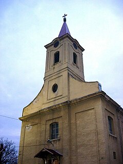
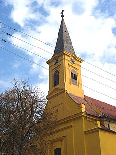
Bátmonostor (Croatian : Monoštorlija) is a village in Bács-Kiskun county, in the Southern Great Plain region of southern Hungary.

Croatian language South Slavic language

Croatian is the standardized variety of the Serbo-Croatian language used by Croats, principally in Croatia, Bosnia and Herzegovina, the Serbian province of Vojvodina and other neighboring countries. It is the official and literary standard of Croatia and one of the official languages of the European Union. Croatian is also one of the official languages of Bosnia and Herzegovina and a recognized minority language in Serbia and neighboring countries.

Village Small clustered human settlement smaller than a town

A village is a clustered human settlement or community, larger than a hamlet but smaller than a town, with a population ranging from a few hundred to a few thousand. Though villages are often located in rural areas, the term urban village is also applied to certain urban neighborhoods. Villages are normally permanent, with fixed dwellings; however, transient villages can occur. Further, the dwellings of a village are fairly close to one another, not scattered broadly over the landscape, as a dispersed settlement.

Southern Great Plain Region in Hungary

The Southern Great Plain is a statistical region of Hungary. It is part of Great Plain and North region. The Southern Great Plain includes three counties:

Contents

Geography

It covers an area of 104.94 km2 (41 sq mi) and has a population of 1503 people (2015). [1]

Area quantity that expresses the extent of a two-dimensional surface or shape, or planar lamina, in the plane

Area is the quantity that expresses the extent of a two-dimensional figure or shape, or planar lamina, in the plane. Surface area is its analog on the two-dimensional surface of a three-dimensional object. Area can be understood as the amount of material with a given thickness that would be necessary to fashion a model of the shape, or the amount of paint necessary to cover the surface with a single coat. It is the two-dimensional analog of the length of a curve or the volume of a solid.

Population All the organisms of a given species that live in the specified region

In biology, a population is the number of all the organisms of the same group or species, which live in a particular geographical area, and have the capability of interbreeding. The area of a sexual population is the area where inter-breeding is potentially possible between any pair within the area, and where the probability of interbreeding is greater than the probability of cross-breeding with individuals from other areas.

Demography

Residents are Magyars. There is a small community of Croats in the village.

Croats Slavic ethnic group

Croats or Croatians are a nation and South Slavic ethnic group native to Croatia. Croats mainly live in Croatia and Bosnia and Herzegovina, but are also recognized minorities in such countries as Austria, the Czech Republic, Germany, Hungary, Italy, Montenegro, Romania, Serbia, Slovakia, and Slovenia.

Related Research Articles

Bački Breg Village in Vojvodina, Serbia

Bački Breg is a village located in the Sombor municipality, in the West Bačka District of Serbia. It is situated in the autonomous province of Vojvodina. The village has a Croat (Šokac) ethnic majority and its population numbering 1,388 people.

Bački Monoštor Place in Vojvodina, Serbia

Bački Monoštor is a village located in the Sombor municipality, in the West Bačka District of Serbia. It is situated in the autonomous province of Vojvodina. The village has a Croat majority. Population of Bački Monoštor is numbering 3,920 people. In 1991 census, largest number of inhabitants of this village declared themselves as Yugoslavs.

Hercegszántó Place in Bács-Kiskun, Hungary

Hercegszántó is a village in the Bács-Kiskun county of Hungary, famous for being the birthplace of footballer Flórián Albert. Residents are Magyars, with minority of Šokci and Orthodox Serbs.

Vaskút Place in Bács-Kiskun, Hungary

Vaskút is a large village in Bács-Kiskun county, in the Southern Great Plain region of southern Hungary.

Tabdi Place in Bács-Kiskun, Hungary

Tabdi is a village and municipality in Bács-Kiskun county, in the Southern Great Plain region of southern Hungary.

Császártöltés Place in Bács-Kiskun, Hungary

Császártöltés is a village in Bács-Kiskun county, in the Southern Great Plain region of southern Hungary.

Érsekcsanád Place in Bács-Kiskun, Hungary

Érsekcsanád is a village in Bács-Kiskun county, in the Southern Great Plain region of southern Hungary. It is named after Csanád, the first head (comes) of the former Csanád County of Hungary in the first decades of the 11th century.

Csátalja Place in Bács-Kiskun, Hungary

Csátalja is a village in Bács-Kiskun county, in the Southern Great Plain region of southern Hungary.

Uszód Place in Bács-Kiskun, Hungary

Uszód is a village in Bács-Kiskun county, in the Southern Great Plain region of southern Hungary.

Miske Place in Bács-Kiskun, Hungary

Miske is a village in Bács-Kiskun county, in the Southern Great Plain region of southern Hungary.

Szeremle Place in Bács-Kiskun, Hungary

Szeremle is a village in Bács-Kiskun county, in the Southern Great Plain region of southern Hungary.

Fajsz, Hungary Place in Bács-Kiskun, Hungary

Fajsz is a village in Bács-Kiskun county, in the Southern Great Plain region of Hungary.

Foktő Place in Bács-Kiskun, Hungary

Foktő is a village in Bács-Kiskun county, in the Southern Great Plain region of Hungary.

Tataháza Place in Bács-Kiskun, Hungary

Tataháza is a village in Bács-Kiskun county, in the Southern Great Plain region of southern Hungary.

Szakmár Place in Bács-Kiskun, Hungary

Szakmár is a village in Bács-Kiskun county, in the Southern Great Plain region of southern Hungary.

Kéleshalom Place in Bács-Kiskun, Hungary

Kéleshalom is a village in Bács-Kiskun county, in the Southern Great Plain region of southern Hungary.

Géderlak Place in Bács-Kiskun, Hungary

Géderlak is a village in Bács-Kiskun county, in the Southern Great Plain region of southern Hungary.

Öregcsertő Place in Bács-Kiskun, Hungary

Öregcsertő is a village in Bács-Kiskun county, in the Southern Great Plain region of southern Hungary.

Csárdaszállás Place in Békés, Hungary

Csárdaszállás is a village in Békés County, in the Southern Great Plain region of south-east Hungary.

Gacsály Place in Szabolcs-Szatmár-Bereg, Hungary

Gacsály is a village in Szabolcs-Szatmár-Bereg county, in the Northern Great Plain region of eastern Hungary.

References

  1. 1 2 Gazetteer of Hungary, 1 January 2015 . Hungarian Central Statistical Office. 3 September 2015

Coordinates: 46°06′N18°56′E / 46.100°N 18.933°E / 46.100; 18.933

Geographic coordinate system Coordinate system

A geographic coordinate system is a coordinate system that enables every location on Earth to be specified by a set of numbers, letters or symbols. The coordinates are often chosen such that one of the numbers represents a vertical position and two or three of the numbers represent a horizontal position; alternatively, a geographic position may be expressed in a combined three-dimensional Cartesian vector. A common choice of coordinates is latitude, longitude and elevation. To specify a location on a plane requires a map projection.