
Cabo da Roca or Cape Roca is a cape which forms the westernmost point of the Sintra Mountain Range, of mainland Portugal, of continental Europe, and of the Eurasian land mass. It is situated in the municipality of Sintra, near Azóia, in the southwest of the district of Lisbon.

Cape Race is a point of land located at the southeastern tip of the Avalon Peninsula on the island of Newfoundland, in Newfoundland and Labrador, Canada. Its name is thought to come from the original Portuguese name for this cape, "Raso", meaning flat or low-lying. The Cape appeared on early sixteenth century maps as Cabo Raso and its name may derive from a cape of the same name at the mouth of the Tagus River in Portugal. The cape was the location of the Cape Race LORAN-C transmitter until the system was decommissioned in 2010. It is also home to the Cape Race Lighthouse, notable for having received the distress call from RMS Titanic.

The Cape Verde national football team represents Cape Verde in men's international association football and is controlled by the Cape Verdean Football Federation. The team has never qualified for FIFA World Cups but has qualified for two tournaments of Africa Cup of Nations, 2013 and 2015.

Sal is an island in Cape Verde. Sal is a tourist destination with white sandy beaches and over 350 days of sunshine a year. It is one of the three sandy eastern islands of the Cape Verde archipelago in the central Atlantic Ocean, 350 mi (560 km) off the west coast of Africa. Cabo Verde is known for year-round kiteboarding, for the large reserve of Caretta turtles which hatch from July to September, and the music of Cesaria Evora.

Santa Luzia is an island of the Barlavento archipelago in Cape Verde located between São Nicolau and São Vicente, the channel of Santa Luzia separates the island of São Vicente and is 8 km wide. The area is 34.2 km². Like all Cape Verdean islands, it is of volcanic origin. The highest point is Topona. Santa Luzia is 12.4 km long and 5.3 km wide.

Ilhéu Raso is an uninhabited 5.76 square kilometres volcanic island in the Barlavento archipelago of Cape Verde. It is flanked by the smaller Branco islet to the west and by São Nicolau island on its eastern side, distance is 15 kilometres from the island of São Nicolau. Together with Santa Luzia and Ilhéu Branco, Ilhéu Raso is on the tentative list of UNESCO's World Heritage sites. Since 1990, the islet is part of the protected area Reserva Natural Integral de Santa Luzia.

Ilhéu Branco is an uninhabited 278-hectare (690-acre) islet in the Barlavento group of the Cape Verde archipelago off the coast of north-west Africa in the Atlantic Ocean. Ilhéu Branco is flanked by the islands of Santa Luzia to the north-west and Ilhéu Raso to the south-east. Since 1990, the islet is part of the protected area Reserva Natural Integral de Santa Luzia. Together with Santa Luzia and Ilhéu Raso, Ilhéu Branco is on the tentative list of UNESCO's World Heritage sites.

Cabo Frio is a tourist destination located in the state of Rio de Janeiro state. It was founded by the Portuguese on November 13, 1615.

The Sintra-Cascais Natural Park is a park on the Portuguese Riviera, one of the 13 Natural Parks of Portugal. While only established in 1994 as a Natural Park by the Portuguese Government, it has been protected since 1981. Its area is approximately 145 km². The park includes the Serra de Sintra Mountain Range but extends all the way to the coast and Cabo da Roca, continental Europe's westernmost point. It contains the Castle of the Moors. Located within 25 km of Lisbon, the Sintra-Cascais Natural Park is a popular tourism area, with many different individual historical and natural sites and attractions. Sintra and Cascais are towns and municipalities in the Lisbon / Estoril Coast.

Cape Verde or Cabo Verde, officially the Republic of Cabo Verde, is an island country in the central Atlantic Ocean. The ten volcanic islands in its archipelago have a combined land area of about 4,033 square kilometres (1,557 sq mi).

RECORD TV is a channel of RecordTV in Cape Verde. It is the first Brazilian based channel to have its own version in Cape Verde. The network was launched on 31 March 2007.
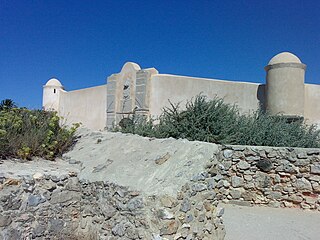
The Fort of São Jorge ) is located on the coastal highway EN 247, near the Oitavos dunes, in the parish and municipality of Cascais, Lisbon district, Portugal. It was one of a series of forts stretching from the Tower of Belem close to Lisbon to Cabo da Roca. It is now a museum.

Cabo Raso Lighthouse is an active Portuguese lighthouse that is located in the Fort of São Brás of Sanxete, near Cascais, Lisbon District. It is a cylindrical, red, metallic tower, thirteen meters high, with a lantern and balcony and attached buildings.
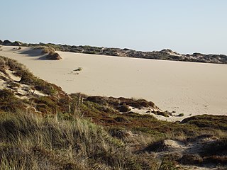
The Cresmina Dune extends over 66 hectares and is a part of the Guincho-Oitavos dune system, located on the edge of the Sintra-Cascais Natural Park near Cascais in Portugal. This dune system is considered fairly unique because, as a result of the prevailing northwest winds, the sand from the Guincho and Cresmina beaches eventually returns to the sea 5km further to the south near Guia, after migrating over the flat, rocky and largely uninhabited area of Cabo Raso.

The Fort of Saint Anthony of Barra ) is located overlooking the sea, in the parish of Estoril, Cascais municipality, District of Lisbon, in Portugal. It is sometimes known as the Old Fort ), or as the Fort of Salazar as it was used by the Prime Minister, António de Oliveira Salazar as his seasonal residence during the Portuguese dictatorship. Until early 2018 the fort had been disused and subject to some vandalism, but it was then restored by the Municipality and opened for public viewing for the first time on April 25, 2018.

Cape Espichel Lighthouse is situated on the western coast of the civil parish of Castelo, municipality of Sesimbra, in the Setúbal district of Portugal. The lighthouse was built in 1790.

The COVID-19 pandemic in Cape Verde is part of the worldwide pandemic of coronavirus disease 2019 caused by severe acute respiratory syndrome coronavirus 2. The virus was confirmed to have reached Cape Verde in March 2020.


 Flora of the cape
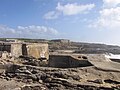 Bunker
 View of Sintra-Cascais Natural Park from the cape
 Pebble beach of the cape


