Transport in Antarctica has transformed from explorers crossing the isolated remote area of Antarctica by foot to a more open era due to human technologies enabling more convenient and faster transport, predominantly by air and water, as well as land. Transportation technologies on a remote area like Antarctica need to be able to deal with extremely low temperatures and continuous winds to ensure the travelers' safety. Due to the fragility of the Antarctic environment, only a limited amount of transport movements can take place and sustainable transportation technologies have to be used to reduce the ecological footprint. The infrastructure of land, water and air transport needs to be safe and sustainable. Currently thousands of tourists and hundreds of scientists a year depend on the Antarctic transportation system.

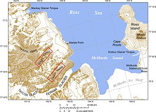
McMurdo Sound and its ice-clogged waters extends about 55 kilometres (34 mi) long and wide. The sound connects the Ross Sea to the north with the Ross Ice Shelf cavity to the south via Haskell Strait. The strait is largely covered by the McMurdo Ice Shelf. The Royal Society Range rises from sea level to 4,205 metres (13,796 ft) on the western shoreline. Ross Island, an historic jumping-off point for polar explorers, designates the eastern boundary. The active volcano Mount Erebus at 3,794 metres (12,448 ft) dominates Ross Island. Antarctica's largest scientific base, the United States' McMurdo Station, as well as the New Zealand Scott Base are on the southern shore of the island. Less than 10 percent of McMurdo Sound's shoreline is free of ice. It is the southernmost navigable body of water in the world.
Koettlitz Glacier is a large Antarctic glacier lying west of Mount Morning and Mount Discovery in the Royal Society Range, flowing from the vicinity of Mount Cocks northeastward between Brown Peninsula and the mainland into the ice shelf of McMurdo Sound.

The Dailey Islands are a group of small volcanic islands lying off the coast of Victoria Land, 9 kilometres (5 nmi) northeast of Cape Chocolate, in the northern part of the ice shelf bordering McMurdo Sound. They were discovered by the British National Antarctic Expedition, 1901–04, under Robert Falcon Scott, and named for Fred E. Dailey, the expedition carpenter.

Castle Rock is a bold rock crag, 415 metres (1,360 ft) high, standing 3 miles (5 km) northeast of Hut Point on the central ridge of Hut Point Peninsula, Ross Island. It was discovered by the British National Antarctic Expedition, 1901–04, under Robert Falcon Scott, who so named it because of its shape.

Hut Point Peninsula is a long, narrow peninsula from 3 to 5 km wide and 24 km (15 mi) long, projecting south-west from the slopes of Mount Erebus on Ross Island, Antarctica. McMurdo Station (US) and Scott Base (NZ) are Antarctic research stations located on the Hut Point Peninsula.

Winter Quarters Bay is a small cove of McMurdo Sound, Antarctica, located 2,200 miles (3,500 km) due south of New Zealand at 77°50'S. The harbor is the southern-most port in the Southern Ocean and features a floating ice pier for summer cargo operations. The bay is approximately 250m wide and long, with a maximum depth of 33m. The name Winter Quarters Bay refers to Robert Falcon Scott's National Antarctic Discovery Expedition (1901–04) which wintered at the site for two seasons.
Priddy Glacier is a glacier, 2 nautical miles (3.7 km) long, on the west side of Esser Hill, flowing northwest to join Hobbs Glacier, on Scott Coast, Victoria Land. Named in 1992 by Advisory Committee on Antarctic Names (US-ACAN) after Allan R. Priddy of Holmes and Narver, Inc., who experienced one winter above 76 in Greenland and one below 76 at McMurdo Station, as well as several summer seasons in Antarctica from 1969-91. He was construction foreman at four geological field camps and for four summer seasons at South Pole Station, and was a key crew member in the building of both Siple I and Siple II Stations.

Cadlina is a genus of sea slugs, dorid nudibranchs, shell-less marine gastropod mollusks historically classified in the family Chromodorididae. Recent research by R.F. Johnson in 2011 has shown that Cadlina does not belong to the family Chromodorididae. She has therefore brought back the name Cadlinidae from synonymy with Chromodorididae. The family Cadlinidae also includes the genus AldisaBergh, 1878.

An iceport is a more-or-less permanent indentation in the front of an ice shelf, that can serve as a natural ice harbor. Though useful, they are not always reliable, as calving of surrounding ice shelves can render an iceport temporarily unstable and unusable.
Williams Cliff is a prominent rock cliff that stands out from the ice-covered southwest slopes of Mount Erebus, situated 6 nautical miles (11 km) east of Cape Barne on Ross Island. This rock cliff was mapped by the British Antarctic Expedition under Scott, 1910–13, and identified simply as "Bold Cliff" on maps resulting from that expedition. It was named Williams Cliff by the Advisory Committee on Antarctic Names (US-ACAN) in 1964 to commemorate Richard T. Williams, who lost his life when his tractor broke through the ice at McMurdo Sound in January 1956.
Wohlschlag Bay is a large bay indenting the west side of Ross Island between Harrison Bluff and Cape Royds. Charted by the Discovery Expedition under Scott, 1901-04. Named by the Advisory Committee on Antarctic Names (US-ACAN) in 1964 for Donald E. Wohlschlag, professor of biology at Stanford University, who outfitted the biology laboratories on the USNS Eltanin and at McMurdo Station, where he worked five summer seasons from 1958-64.
Worthley Peak is a peak, 840 m, at the north end of Benson Ridge overlooking lower Robb Glacier. Mapped by the United States Geological Survey (USGS) from tellurometer surveys and Navy air photos, 1960-62. Named by Advisory Committee on Antarctic Names (US-ACAN) for Elmer G. Worthley, United States Antarctic Research Program (USARP) bryologist at McMurdo Sound, 1958-59.

Baronick Glacier is a glacier 6 nautical miles (11 km) southwest of Mount Cocks, in the Royal Society Range, draining into the Skelton Glacier to the west. It was named by the Advisory Committee on Antarctic Names in 1963 for Chief Aviation Ordnanceman Michael P. Baronick, of U.S. Navy Squadron VX-6, who wintered at Williams Air Operating Facility at McMurdo Sound in 1956 and was in Antarctica for several summer seasons. Baronick, with a party of three, was in command of the Beardmore Air Operating Facility established on October 28, 1956, at 84°56′S166°0′W.
Esser Hill is a peak, 1,235 metres (4,050 ft) high, standing between the divergent flow of Priddy Glacier and Blackwelder Glacier, 1 nautical mile (2 km) southwest of Chambers Hill, on the Scott Coast of Victoria Land. It was named in 1992 by the Advisory Committee on Antarctic Names after Alan C. Esser of Holmes and Narver, Inc., who served as Project Manager of Antarctic Support Activities, 1976–80, and was responsible for contractor operations at McMurdo Station, South Pole Station and Siple Station, as well as field activities in support of the U.S. Antarctic Program.
Fitzgerald Stream is a stream between Fitzgerald Hill and Inclusion Hill on the lower ice-free west slopes of Mount Bird, Ross Island, flowing to McMurdo Sound across McDonald Beach. It was explored by the New Zealand Geological Survey Antarctic Expedition, 1958–59, and named by the New Zealand Antarctic Place-Names Committee for E.B. Fitzgerald, deputy leader of the expedition.
Ford Rock is a prominent rock which lies 1 nautical mile (2 km) northeast of Cone Hill on Hut Point Peninsula, Ross Island, Antarctica. Cone Hill and this rock were designated "Cone Hill I" and "Cone Hill II," respectively, by the British Antarctic Expedition, 1910–13, under Robert Falcon Scott. Cone Hill has been approved for Scott's "Cone Hill I," but a new name suggested by A.J. Heine has been substituted for this prominent rock. M.R.J. Ford, a New Zealand surveyor, established a survey beacon network for the McMurdo Ice Shelf Project, 1962–63. A survey beacon was established earlier on this rock by a U.S. Hydrographic Office survey team, 1955–56.
Mattox Bastion is one of the peaks of the Inland Forts in the Asgard Range, Victoria Land, Antarctica. Flory Cirque sits on its southwest slopes, on the north side of Taylor Glacier, between a pair of rock spurs named West Groin and East Groin. West Groin separates Flory Cirque from Mudrey Cirque.
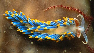
Tenellia giarannae is a species of sea slug, an aeolid nudibranch, a marine gastropod mollusc in the family Fionidae.
Cuthonella elioti is a species of sea slug, an aeolid nudibranch, a marine gastropod mollusc in the family Cuthonellidae. It is a replacement name for Cuthonella antarctica Eliot, 1907.


