
The Llobregat is the second longest river in Catalonia, Spain, after the Ter. It flows into the Mediterranean south of the city of Barcelona. Its name could have originated in an ancient Latin word meaning 'dark', 'muddy' or 'slippery', or simply from its ancient name Rubricatus, literally 'red'.

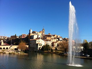
La Seu d'Urgell is a town located in Alt Urgell county in Alt Pirineu, Catalonia, Spain. The town is also the head of its judicial district and the seat of the Bishop of Urgell, one of the co-princes of Andorra. It is located the most populated town of the region, with 17.4% of its population. La Seu d'Urgell and Puigcerdà together have 30% of the population of the area.
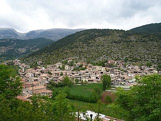
Gósol is a village and municipality located in the northwest of the comarca of Berguedà in Catalonia, Spain. It is within the confines of Cadí-Moixeró Natural Park in the Pyrenees, to the west of Pedraforca.

Berguedà is an inland comarca in the central region of Catalonia, Spain. It lies partly in the Pyrenees and Pre-Pyrenees, and partly in the Catalan Central Depression. The capital is the city of Berga.

The Pre-Pyrenees are the foothills of the Pyrenees.

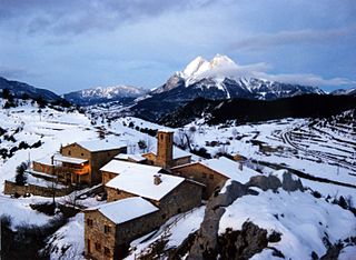
Josa i Tuixén or Josa i Tuixent is a municipality in the comarca of the Alt Urgell in Catalonia, Spain. It is situated on the southern side of the Pyrenean range of Serra del Cadí in the east of the comarca. The ajuntament is located in Tuixén. Local roads link the municipality with La Seu d'Urgell and with Sant Llorenç de Morunys. It is a centre for Nordic skiing.

C-16 or Eix del Llobregat is a primary highway in Catalonia, Spain. It is also part of the European route E9, from Orléans (France) to Barcelona.
Gironella is a municipality in the comarca of the Berguedà in Catalonia, Spain. It is situated in the left bank of the Llobregat river to the south of Berga. The local economy is traditionally based on cotton spinning and textile manufacture, although tourism is now more important: the company towns or "colonies" of workers houses surround the cotton mills are of historical interest. The town is served by the C-16 road to Berga and the Cadí tunnel. Gironella, which has numerous stores, bars, and schools, is an important economic center for the smaller towns around it, such as Olvan, Sagàs or Casserres.

Alt Pirineu is one of the nine regions (vegueries) of Catalonia.
Tuixent-La Vansa is a ski resort for Nordic skiing in Josa i Tuixén and la Vansa i Fórnols, Catalonia, opened in 1978. It is located in the northern face of the Port del Comte range, from l'Arp at 1,830 metres (6,000 ft) to Prat Llong at 2,150 metres (7,050 ft), between the municipalities of Josa i Tuixén and la Vansa i Fórnols, so the resort name include both. It borders the Cadí-Moixeró Natural Park.

Ports de Tortosa-Beseit, also known as Ports de Beseit, or simply as Els Ports or Lo Port by locals, is a limestone mountain massif located at the north-eastern end of the Sistema Ibérico, a complex system of mountain ranges and massifs in the centre of the Iberian Peninsula. Its highest point is Mont Caro, 1,441 m. Rivers such as the Matarranya and the Cenia have their source in these mountains.
Gisclareny is a municipality in the comarca of Berguedà, Catalonia, located in Cadí-Moixeró Natural Park. In 2018 it became again the smallest village in Catalonia after the village of Sant Jaume de Frontanyà grew by 3 families. The altitude of the inhabited space varies between 800 meters in the neighborhood of Bagà and 1430 in the neighborhood of Coll de la Bena. It is bounded on the north by the Cerdanya, reaching the peaks of the Serra del Cadí, and by Bagà, on the south and west by Saldes and Vallcebre, and on the east by Bagà and Guardiola de Berguedà. The alpine forests and meadows are the usual landscape of the municipality as well as a multitude of farmhouses scattered throughout the territory.

Vulturó is a mountain located in the comarca of Alt Urgell in Catalonia, Spain. It has an elevation of 2,648 metres above sea level. It is the highest mountain in the Serra del Cadí mountain range, and in the Catalan Pre-Pyrenees.

The Catalan Coastal Range is a system of mountain ranges running parallel to the Mediterranean Sea coast in Catalonia, Spain. It is part of the Catalan Mediterranean System. Its main axis runs between the Foix River and the Roses Gulf and the average altitude is around 500 m. The highest point is 763 m at the Montnegre.

Serra de Montsant is a mountain chain in Catalonia, Spain. The main populated area in the range is La Morera de Montsant.

Bellver de Cerdanya is a town in the comarca of Cerdanya, province of Lleida, Catalonia, Spain.
Serra d'Irta is an 18.8 km long mountain range in the Baix Maestrat comarca, Valencian Community, Spain. Its highest point is Pico Campanelles.
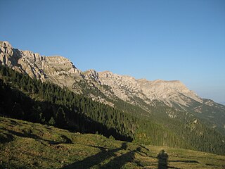
The Serra del Cadí is a mountain range in the north of Catalonia, Spain, part of the Pre-Pyrenees. Its highest peak is the Vulturó, with an altitude of 2,648 metres (8,688 ft).

Cadí Tunnel is a toll road tunnel in Catalonia, Spain, connecting the comarques of Cerdanya and Berguedà. The tunnel, with a length of 5,026 m (16,490 ft), is part of the C-16 highway and E-9, running under the Serra de Moixeró mountain range in the Pre-Pyrenees.
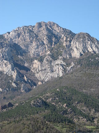
The Serra de Moixeró is a mountain range running across the north of Catalonia (Spain), part of the Pre-Pyrenees. Along with the adjacent Serra del Cadí, Pedraforca and parts of Tosa d'Alp and Puigllançada, it forms part of the Cadí-Moixeró Natural Park, established in 1983.

