
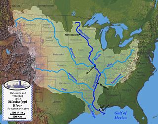
The Mississippi River is the primary river of the largest drainage basin in the United States. From its traditional source of Lake Itasca in northern Minnesota, it flows generally south for 2,340 miles (3,766 km) to the Mississippi River Delta in the Gulf of Mexico. With its many tributaries, the Mississippi's watershed drains all or parts of 32 U.S. states and two Canadian provinces between the Rocky and Appalachian mountains. The river either borders or passes through the states of Minnesota, Wisconsin, Iowa, Illinois, Missouri, Kentucky, Tennessee, Arkansas, Mississippi, and Louisiana. The main stem is entirely within the United States; the total drainage basin is 1,151,000 sq mi (2,980,000 km2), of which only about one percent is in Canada. The Mississippi ranks as the world's tenth-largest river by discharge flow, and the largest in North America.
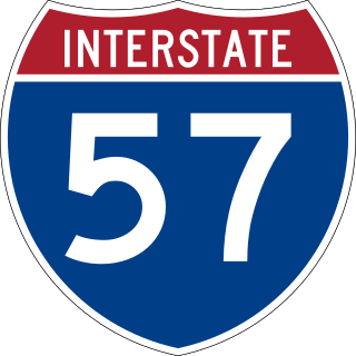
Interstate 57 (I-57) is a north–south Interstate Highway that currently exists in two segments. It runs through Arkansas, Missouri, and Illinois. I-57 parallels the old Illinois Central Railroad for much of its route north of I-55. The Interstate begins at I-40 in North Little Rock, Arkansas, traveling northward concurrently with U.S. Highway 67 (US 67) until it reaches Walnut Ridge, Arkansas, where the Interstate ends for now. I-57 will run northward to meet up with the existing segment in southeastern Missouri. I-57 resumes its run from Sikeston, Missouri, at I-55 to Chicago, Illinois, at I-94. I-57 essentially serves as a shortcut route for travelers headed between the Southern United States and Chicago, bypassing St. Louis, Missouri, and Springfield, Illinois. Between the junction of I-55 and I-57 in Sikeston and the junction of I-55 and I-90/I-94 in Chicago, I-55 travels for 436 miles (702 km), while the combination of I-57 and I-94 is only 396 miles (637 km) long between the same two points. In fact, both the control cities on the overhead signs and the destination mileage signs reference Memphis along southbound I-57, even as far north as its northern origin at I-94 in Chicago. Likewise, at its southern end in Missouri, Chicago is the control city listed for I-57 on signs on northbound I-55 south of Sikeston, even though I-55 also goes to Chicago.

Interstate 64 (I-64) is an east–west Interstate Highway in the Eastern United States. Its western terminus is at I-70, U.S. Route 40 (US 40), and US 61 in Wentzville, Missouri. Its eastern terminus is at the Bowers Hill Interchange with I-264 and I-664 at Bower's Hill in Chesapeake, Virginia. I-64 connects Greater St. Louis, the Louisville metropolitan area, the Lexington–Fayette metropolitan area, the Charleston metropolitan area, the Greater Richmond Region, and Hampton Roads.
Cairo is the southernmost city in Illinois and the county seat of Alexander County. A river city, Cairo has the lowest elevation of any location in Illinois and is the only Illinois city to be surrounded by levees. It is in the river-crossed area of Southern Illinois known as "Little Egypt", for which the city is named, after Egypt's capital on the Nile. The city is coterminous with Cairo Precinct.

Southern Illinois is a region of the U.S. state of Illinois comprising the southern third of the state, principally south of Interstate 70. Part of downstate Illinois, it is bordered by the two most voluminous rivers in the United States: the Mississippi below its connection with the Missouri River to the west and the Ohio River to the east and south, with the tributary Wabash River, extending the southeastern border. Some areas of Southern Illinois are known historically as Little Egypt.

U.S. Route 62 or U.S. Highway 62 (US 62) is an east–west United States Highway in the southern and northeastern United States. It runs from the Mexican border at El Paso, Texas, to Niagara Falls, New York, near the Canadian border. It is the only east–west United States Numbered Highway that connects Mexico and Canada. Parts of US 62 follow what once was the Ozark Trail, including the historic bridge across the South Canadian River in Newcastle, Oklahoma. This bridge was damaged beyond repair by the 2013 Moore tornado that struck Newcastle and Moore, Oklahoma. The highway is signed north–south in New York and Pennsylvania reflecting its directional orientation in both states, and is signed east-west the remainder of its course.

Interstate 255 (I-255) is a bypass route of I-55 in Greater St. Louis. Along with I-270, it forms a loop around the central portion of the bi-state metro area; a majority of I-255 is located on the Illinois half. It shares its southern terminus with I-270 at the junction with I-55; I-270 and I-255 go to the west and east, respectively. U.S. Route 50 (US 50) joins I-255 at Lemay Ferry Road. It crosses the Mississippi River on the Jefferson Barracks Bridge, enters Illinois, and then turns northeast. There is a junction with I-64, where US 50 breaks off and goes east, and then further north there is a junction with I-55 again, I-70, and US 40, all of which are all cosigned together. The next junction is another one with I-270, which is the northern terminus of I-255. After that, the limited-access freeway continues on as Illinois Route 255 (IL 255). I-255 is 30.82 miles (49.60 km) in length.
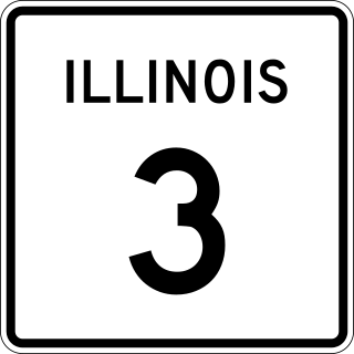
Illinois Route 3 (IL 3) is a 187.44-mile-long (301.66 km) major north–south arterial state highway in southwestern Illinois. It has its southern terminus at Cairo Junction at the intersection of U.S. Route 51 (US 51) and Illinois Route 37, and its northern terminus in Grafton at IL 100.

Interstate 270 (I-270) makes up a large portion of the outer belt freeway in Greater St. Louis. The counterclockwise terminus of I-270 is at the junction with I-55 and I-255 in Mehlville, Missouri; the clockwise terminus of the freeway is at the junction with I-55 and I-70 north of Troy, Illinois. The entire stretch of I-270 is 50.59 miles (81.42 km).

The McKinley Bridge is a steel truss bridge across the Mississippi River. It connects northern portions of the city of St. Louis, Missouri with Venice, Illinois. It opened in 1910 and was taken out of service on October 30, 2001. The bridge was reopened for pedestrian and bicyclists on November 17, 2007, with a grand re-opening celebration. Since December 2007, McKinley has been open to vehicular traffic as well. It is accessible from Illinois Route 3 in Illinois and from the intersection of Salisbury and North 9th Street in the city of St. Louis. The bridge carried both railroad and vehicular traffic across the Mississippi River for decades. By 1978, the railroad line over the span was closed, and an additional set of lanes was opened for vehicles in the inner roadway.
The Martin Luther King Bridge in St. Louis, Missouri, is a cantilever truss bridge of about 4,000 feet (1,200 m) in total length across the Mississippi River, connecting St. Louis with East St. Louis, Illinois. Opened in 1951, the bridge serves as traffic relief connecting the concurrent freeways of Interstate 55, Interstate 64, and U.S. Route 40 with the downtown streets of St. Louis. It was renamed for King in 1968 after the national civil rights leader was assassinated that year.
Bird's Point is an unincorporated community in Mississippi County, Missouri, United States. It lies on an island or former island in the Mississippi River, near the confluence of the Ohio and Mississippi Rivers and is situated directly across from Cairo, Illinois. This is the point where the U.S. Route 60 bridge connects with Cairo.

The New Chain of Rocks Bridge is a pair of bridges across the Mississippi River on the north edge of St. Louis, Missouri. It was constructed in 1966 to bypass the Chain of Rocks Bridge immediately to the south. It originally carried traffic for Bypass US 66 and currently carries traffic for Interstate 270. The bridge opened to traffic on September 2, 1966.

The Cairo Ohio River Bridge is a cantilever bridge carrying U.S. Route 51, U.S. Route 60, and U.S. Route 62 across the Ohio River between Wickliffe, Kentucky and Cairo, Illinois. Of all the Ohio River crossings, it is the furthest downstream; the Mississippi River can be seen while crossing the bridge and looking westward.
The Mississippi River System, also referred to as the Western Rivers, is a mostly riverine network of the United States which includes the Mississippi River and connecting waterways. The Mississippi River is the largest drainage basin in the United States. In the United States, the Mississippi drains about 41% of the country's rivers.

The Lower Mississippi River is the portion of the Mississippi River downstream of Cairo, Illinois. From the confluence of the Ohio River and the Middle Mississippi River at Cairo, the Lower flows just under 1000 miles (1600 km) to the Gulf of Mexico. It is the most heavily travelled component of the Mississippi River System.

Interstate 66 (I-66) is a canceled Interstate Highway designated in the Intermodal Surface Transportation Efficiency Act (ISTEA) of 1991 as the East–West TransAmerica Corridor and High Priority Corridor 3.

U.S. Route 60 and U.S. Route 62 (US 60/US 62) run for a very short distance within the state of Illinois. The highways run concurrently for their entire existence within the state. The joint highway runs around Fort Defiance in Cairo, from the Cairo Mississippi River Bridge over the Mississippi River east to the Cairo Ohio River Bridge over the Ohio River; the Ohio River Bridge also carries US 51. The bridges cross the two rivers just north of the mouth of the Ohio.

The Champ Clark Bridge was a five-span truss bridge over the Mississippi River connecting Louisiana, Missouri with the state of Illinois via US 54. It opened in 1928. In 2019, the bridge was replaced by a new bridge of the same name.

U.S. Route 67 (US 67) is a component of the United States Numbered Highway System that connects Presidio, Texas, to Sabula, Iowa. In Illinois, it serves the western region of the state known as Forgottonia, named for the lack of regional transportation and infrastructure projects. The highway begins its path through the state by crossing the Clark Bridge over the Mississippi River from Missouri at Alton and heads northward through Jerseyville and Jacksonville before it crosses the Illinois River at Beardstown. The northern half of the route serves Macomb and Monmouth before it enters the Quad Cities. It leaves the state at Rock Island by crossing the Rock Island Centennial Bridge over the Mississippi River into Davenport, Iowa.


