
Monyash is a village and civil parish in the Peak District, Derbyshire, England, 5 miles (8 km) west of the market town Bakewell. It is centred on a village green 265 metres (869 ft) above sea level at the head of Lathkill Dale in the limestone area known as the White Peak. At the 2011 census, it had a population of 314. Tourism and farming are the predominant activities of the village. The area was once an important meeting place, a watering point for drovers’ animals at the intersection of several trade routes, and industrial centre supporting the local lead mining industry.

The River Lathkill is a river in the Peak District National Park in Derbyshire, England.

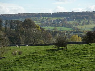
Lathkill Dale is the valley of the River Lathkill near Bakewell, Derbyshire in the Peak District of England. The river emerges into the dale from springs below Lathkill Head Cave. Towards the head of the dale is the side valley Cales Dale.

The Limestone Way is a waymarked long-distance footpath in Derbyshire, England. It runs for 46 miles (74 km) through the White Peak of the Peak District National Park, from Castleton south to Rocester over the county boundary into Staffordshire. The trail is named for the limestone scenery along its route. It was devised by Brian Spencer of Matlock Rotary Club and developed and opened in 1986 by the West Derbyshire District Council. It originally ran to Matlock, but was extended to its current, longer route in 1992 to join up with the Staffordshire Way.

Ballidon is a village and civil parish in the Derbyshire Dales district of Derbyshire, England, on the edge of the Peak District National Park. According to the 2001 census it had a population of 79. The population at the 2011 Census remained less than 100. Details are maintained in the civil Parish of Aldwark, Derbyshire.
Conksbury is the site of a deserted medieval settlement between Over Haddon and Youlgreave in Derbyshire, England.
The Derbyshire Dales National Nature Reserve is a series of unconnected limestone dales in the Peak District National Park. It is managed by Natural England and has a permanent staff of wardens who carry out conservation works and ensure the dales are usable for recreation.

Benty Grange is a Site of Special Scientific Interest in the parish of Monyash in Derbyshire, England. 21.1 ha in size and with at least four species of grass and ten others of plant, it is considered of national importance as one of the largest areas of unimproved species-rich neutral lowland grassland in the Peak District National Park. The area was confirmed as a Site of Special Scientific Interest on 8 March 2013, following notification of the designation on 19 June 2012.
Monk's Dale is a short steep-sided dry gorge near Buxton, Derbyshire, in the Peak District of England. The dale is cut into a plateau of farmland and lies to the east of the village of Wormhill. The head of the valley leads into Peter Dale to the north. Miller's Dale is at the foot of the valley to the south.

Cressbrook Dale is a dry carboniferous limestone gorge near Bakewell, Derbyshire, in the Peak District of England. The dale is cut into a plateau of farmland and lies to the south east of the village of Litton. Cressbrook village is at the foot of the valley to the south.

The Wye Valley is the limestone valley of the River Wye in the White Peak of Derbyshire, England. The source of the River Wye is west of Buxton on Axe Edge Moor. One main channel runs underground through Poole's Cavern. The river flows though Buxton Pavilion Gardens and then along a culvert under the town centre. After leaving the flat area of central Buxton, the Wye Valley becomes distinct as a gorge running east for 10 miles (16 km) before the valley broadens at Ashford-in-the Water.

Long Dale is a carboniferous limestone valley near the village of Elton, Derbyshire, in the Peak District of England. The dale is cut into the plateau of Gratton Moor and Smerrill Moor and lies to the north of the hamlet of Pikehall, which is the venue of the annual Y Not Festival. Midway down the valley it turns sharply left and is known as Gratton Dale. Most of the valley is dry but Rowlow Brook flows down the lower part of Gratton Dale towards Dale End and onwards to become the River Bradford at Youlgreave.

This is a list of scheduled monuments in the Borough of Erewash in the English county of Derbyshire.

This is a list of scheduled monuments in the district of Derbyshire Dales in the English county of Derbyshire.
This is a list of scheduled monuments in the district of South Derbyshire in the English county of Derbyshire.

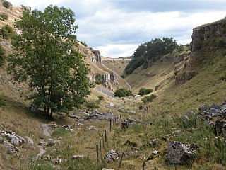
Ballidon Dale is a steep-sided, dry carboniferous limestone valley near Parwich in the Derbyshire Peak District of England. The ancient hamlet of Ballidon lies at the southern foot of the dale. Ballidon Quarry and Hoe Grange limestone quarries now dominate the west side of the dale.
Middleton and Smerrill is a civil parish within the Derbyshire Dales district, in the county of Derbyshire, England. Largely rural except for the village of Middleton-by-Youlgreave and isolated farms, Middleton and Smerrill's population is 137 residents in 2011. It is 130 miles (210 km) north west of London, 20 miles (32 km) north west of the county city of Derby, and 4+1⁄2 miles (7.2 km) south west of the nearest market town of Bakewell. Middleton and Smerrill is wholly within the Peak District national park, in the southern part of the area. It is one of the largest parishes but among the smallest by way of residents, and shares a border with the parishes of Gratton, Hartington Middle Quarter, Hartington Nether Quarter, Hartington Town Quarter, Monyash and Youlgreave. There are 31 listed structures in Middleton and Smerrill.
Monyash is a civil parish in the Derbyshire Dales district of Derbyshire, England. The parish contains 17 listed buildings that are recorded in the National Heritage List for England. Of these, one is listed at Grade II*, the middle of the three grades, and the others are at Grade II, the lowest grade. The parish contains the village of Monyash and the surrounding countryside. Most of the listed buildings are houses, cottages and associated structures, farmhouses and farm buildings. The other listed buildings include a church, a former chapel, a village cross, a public house, and a telephone kiosk.
Unstone is a civil parish in the North East Derbyshire district of Derbyshire, England. The parish contains 15 listed buildings that are recorded in the National Heritage List for England. Of these, two are listed at Grade II*, the middle of the three grades, and the others are at Grade II, the lowest grade. The parish contains the villages of Unstone, Apperknowle and West Handley and smaller settlements, and is otherwise rural. Apart from a railway viaduct, all the listed buildings are houses, cottages and associated structures, farmhouses, and farm buildings.

