The Canary Islands, also known informally as the Canaries, are a Spanish region, autonomous community and archipelago in the Atlantic Ocean. At their closest point to the African mainland, they are 100 kilometres west of Morocco and the Western Sahara. They are the southernmost of the autonomous communities of Spain. The islands have a population of 2.2 million people and are the most populous special territory of the European Union.

Fuerteventura is one of the Canary Islands, in the Atlantic Ocean, geographically part of Macaronesia, and politically part of Spain. It is located 97 km (60 mi) away from the coast of North Africa. The island was declared a biosphere reserve by UNESCO in 2009.

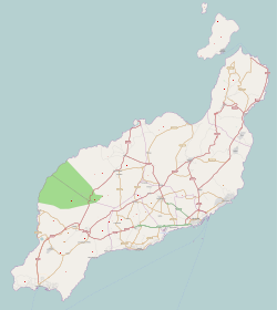
Lanzarote is a Spanish island, the easternmost of the Canary Islands in the Atlantic Ocean, 125 kilometres off the north coast of Africa and 1,000 kilometres from the Iberian Peninsula. Covering 845.94 square kilometres, Lanzarote is the fourth-largest of the islands in the archipelago. With 152,289 inhabitants at the start of 2019, it is the third most populous Canary Island, after Tenerife and Gran Canaria. Located in the centre-west of the island is Timanfaya National Park, one of its main attractions. The island was declared a biosphere reserve by UNESCO in 1993. The island's capital is Arrecife, which lies on the eastern coastline. It is the smaller main island of the Province of Las Palmas.

Graciosa Island or commonly La Graciosa is a volcanic island in the Canary Islands of Spain, located two kilometres north of Lanzarote across the Strait of El Río. As the rest of the Canary Islands, it was formed by the Canary hotspot. The island is part of the Chinijo Archipelago and the Chinijo Archipelago Natural Park. It is administered by the municipality of Teguise in the neighboring island of Lanzarote. In 2018 La Graciosa was officially declared the eighth Canary Island by the Spanish Senate, with few real effects. Before then, the island had the status of an islet. It's administratively dependent on the island of Lanzarote.

Teguise is a municipality in the central part of the island of Lanzarote in the Las Palmas province in the Canary Islands. The population is 22,342, and the area is 263.98 km2. It is located north of Arrecife and south of Haría. The seat of the municipality is the town of Teguise. The municipality also comprises a number of neighbouring islands including Graciosa, Alegranza, Roque del Este, Roque del Oeste and Montaña Clara.

The Chinijo Archipelago is a small archipelago located in the northeastern part of the Canary Islands, north of the island of Lanzarote. The archipelago includes the islets of Montaña Clara, Alegranza, La Graciosa, Roque del Este and Roque del Oeste. The archipelago is administered by Lanzarote and belongs to the municipality of Teguise. La Graciosa is the only inhabited island, with a population of around 700.

César Manrique Cabrera was a Spanish artist, sculptor and nature activist from Lanzarote, known particularly for the architectural projects in which he was involved as artistic director in his island.

A cabildo insular is the government and administration institution of each of the seven major islands in the Canary Islands archipelago: Tenerife, Fuerteventura, Gran Canaria, Lanzarote, La Palma, La Gomera and El Hierro. The island of La Graciosa falls under the jurisdiction of the cabildo of Lanzarote.

Santa Cruz de la Palma is a city and a municipality on the east coast of the island of La Palma in the province of Santa Cruz de Tenerife of the Canary Islands. Santa Cruz de la Palma is the second-largest city and is the capital of the island. It is along an old lava flow coming from the Caldereta, a volcano just south of the city. Santa Cruz de La Palma has the privilege of having the first democratically elected town hall in Spain.

Órzola is a village in the municipality of Haría on the island of Lanzarote in the Canary Islands. It is the northernmost settlement of the island. As of 2021, it has a population of 352 inhabitants.
Corralejo is a town and resort located on the northern tip of Fuerteventura, one of the Canary Islands, facing the smaller islet of Lobos. It is in the municipality of La Oliva.

Casas de Pedro Barba, or simply Pedro Barba, is a small community of summer residences on the island of La Graciosa, Canary Islands, Spain. Its population, as of 1 January 2018 and according to the Spanish Statistical Institute, is of 3 inhabitants. It is part of the municipality of Teguise on the neighbouring island of Lanzarote. There are no asphalted roads on La Graciosa; a dirt track connects the settlement to the only other inhabited town on the island, Caleta de Sebo, from which a regular ferry service is offered to Lanzarote.
Bankia was a Spanish financial services company that was formed in December 2010, consolidating the operations of seven regional savings banks, and was partially nationalized by the government of Spain in May 2012 due to the near-collapse of the institution. As of 2017, Bankia was the fourth largest bank in Spain, with total assets of €179.1 billion. In 2021, the bank merged with CaixaBank to create a new entity, initially preserving its original name.
Playa de la Cocina is a beach on La Graciosa island, part of the municipality of Teguise in Lanzarote, Spain. It is situated near the southwestern point of the island, in a little bay at the foot of the Montaña Amarilla. It is a 10 minutes walk from Playa Francesa in the southwest of the Caleta de Sebo village. The beach's average width is 10 meters and length is 100 metres.

Temple Hall was a cargo motor ship that was built in Scotland in 1954. She was later renamed Pantelis in 1969 and then again as Telamon in 1977.

Spain is an eminently maritime country with a long continental shelf running along the entire periphery of the Spanish coast. This narrow continental shelf is extremely rich in fish resources since the shelf is close to land.
Famara is the main mountainous massif in the north of the island of Lanzarote in the Canary Islands. It is the eastern slope of a volcano erupting in the Miocene. The cliffs of Famara are the remains of a caldera of about ten kilometres in diameter centred on the south of La Graciosa.

El Río is the name given to the sea strait that separates La Graciosa from Lanzarote in the Canary Islands. Río, in Spanish, means 'river'. At its narrowest point, the strait is just over 1.1 kilometres wide.