Indian Territory and the Indian Territories are terms that generally described an evolving land area set aside by the United States government for the relocation of Native Americans who held original Indian title to their land as a sovereign independent state. The concept of an Indian territory was an outcome of the U.S. federal government's 18th- and 19th-century policy of Indian removal. After the American Civil War (1861–1865), the policy of the U.S. government was one of assimilation.

Decatur County is a county located in Northwest Kansas. Its county seat and most populous city is Oberlin. As of the 2020 census, the county population was 2,764. The county was named in honor of Stephen Decatur, Jr., a commodore in the United States Navy who served during both Barbary Wars in North Africa, the Quasi-War with France, and the War of 1812 with Britain.

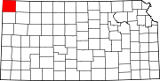
Cheyenne County is a county located in the northwest corner of the U.S. state of Kansas. Its county seat and most populous city is St. Francis. As of the 2020 census, the county population was 2,616. The county was named after the Cheyenne tribe.

Cheyenne County is a county located in the U.S. state of Colorado. The county population was 1,748 at 2020 census. The county seat is Cheyenne Wells.

Geary is a city in Blaine and Canadian counties in the U.S. state of Oklahoma. The population was 994 at the 2020 census. The town was named for Edmund Guerrier, a scout and an interpreter for the U.S. Army.

The Sand Creek massacre was a massacre of Cheyenne and Arapaho people by the U.S. Army in the American Indian Wars that occurred on November 29, 1864, when a 675-man force of the Third Colorado Cavalry under the command of U.S. Volunteers Colonel John Chivington attacked and destroyed a village of Cheyenne and Arapaho people in southeastern Colorado Territory, killing and mutilating an estimated 69 to over 600 Native American people. Chivington claimed 500 to 600 warriors were killed. However, most sources estimate around 150 people were killed, about two-thirds of whom were women and children. The location has been designated the Sand Creek Massacre National Historic Site and is administered by the National Park Service. The massacre is considered part of a series of events known as the Colorado Wars.

The Arikaree River is a 156-mile-long (251 km) river in the central Great Plains of North America. It lies mostly in the American state of Colorado, draining land between the North and South Forks of the Republican River, and it flows into the North Fork in Nebraska after flowing a short distance through Kansas. It is a designated area within the Colorado Natural Areas Program to protect native and uncommon species that may be endangered or threatened.
Arapahoe is an unincorporated town, a post office, and a census-designated place (CDP) located in and governed by Cheyenne County, Colorado, United States. The population was 102 at the 2020 census. The Arapahoe post office has the ZIP code 80802.

Cheyenne is the capital and most populous city of the U.S. state of Wyoming, as well as the county seat of Laramie County, with 65,132 residents, per the 2020 US Census. It is the principal city of the Cheyenne metropolitan statistical area which encompasses all of Laramie County and had 100,512 residents as of the 2020 census. Local residents named the town for the Cheyenne Native American people in 1867 when it was founded in the Dakota Territory. Along with Oklahoma City, Oklahoma and Topeka, Kansas, Cheyenne is one of three state capitals with an indigenous name in a state with an indigenous name.
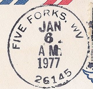
Five Forks is an unincorporated community in Calhoun County, West Virginia, United States. It lies along West Virginia Route 16 to the north of the town of Grantsville, the county seat of Calhoun County. Its elevation is 1,106 feet (337 m). The Five Forks Post Office is closed.

Cheyenne Township is a township in Barton County, Kansas, United States. As of the 2010 census, its population was 207.

Calhoun Township is a township in Cheyenne County, Kansas, USA. As of the 2000 census, its population was 57. In 1898, the population was 253.

Redwing is an unincorporated community in Cheyenne Township, Barton County, Kansas, United States. It is located 1.5 miles (2.4 km) northwest of the northern edge of the Cheyenne Bottoms Wildlife Area, 6.0 miles (9.7 km) east of the city of Hoisington, and 7.0 miles (11.3 km) west of the city of Claflin.
Calhoun Township may refer to the following townships in the United States:

Wheeler is an unincorporated community in Cheyenne County, Kansas, United States.
Cheyenne is a ghost town in Jackson Township, Osborne County, Kansas, United States.
Hourglass is a ghost town in Cheyenne County, Kansas, United States.
Lawnridge is a ghost town in Cheyenne County, Kansas, United States.
Marney is a ghost town in Cheyenne County, Kansas, United States.