Related Research Articles

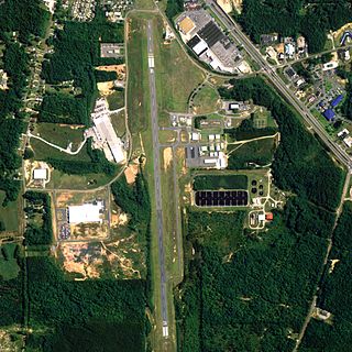
Anniston Regional Airport, formerly known as Anniston Metropolitan Airport, is a city-owned public-use airport located five nautical miles southwest of the central business district of Anniston, a city in Calhoun County, Alabama, United States. It is included in the National Plan of Integrated Airport Systems for 2011–2015, which categorized it as a general aviation airport.

Shelby County Airport is a public use airport located four nautical miles (7 km) southeast of the central business district of Alabaster, a city in Shelby County, Alabama, United States. It is owned by the Shelby County Commission. The airport is situated in the city of Calera.

Ralph M. Calhoun Memorial Airport is a state-owned public-use airport located one nautical mile (1.85 km) west of the central business district of Tanana, a city in the Yukon-Koyukuk Census Area of the U.S. state of Alaska.
Thomas C. Russell Field is a city-owned public-use airport located two nautical miles (4 km) southwest of the central business district of Alexander City, a city in Tallapoosa County, Alabama, United States.

Chilton County Airport, also known as Gragg-Wade Field, is a public-use airport in Chilton County, Alabama, United States. It is located one nautical mile (2 km) east of the central business district of Clanton, Alabama. It is owned by the Chilton County Airport Authority.

Clayton Municipal Airport is a city-owned, public-use airport located two nautical miles west of the central business district of Clayton, a city in Barbour County, Alabama, United States.
Richard Arthur Field is a city-owned public-use airport located three nautical miles northeast of the central business district of Fayette, a city in Fayette County, Alabama, United States.

Florala Municipal Airport is a city-owned public-use airport located three nautical miles northeast of the central business district of Florala, a city in Covington County, Alabama, United States.

Posey Field is a city-owned public-use airport located three nautical miles northeast of the central business district of Haleyville, a city in Winston County, Alabama, United States.

Hartselle–Morgan County Regional Airport is a public-use airport located two nautical miles south of the central business district of Hartselle, a city in Morgan County, Alabama, United States. The airport was formerly known as Rountree Field, named in the 1960s for Asa Rountree Sr., a former head of the Alabama Department of Aeronautics.
Jackson Municipal Airport is a city-owned public airport two miles south of Jackson, in Clarke County, Alabama.

North Pickens Airport is a county-owned public-use airport in Pickens County, Alabama, United States. It is located one nautical mile north of the central business district of Reform, Alabama. The airport is included in the FAA's National Plan of Integrated Airport Systems for 2011–2015, which categorized it as a general aviation facility.
Yazoo County Airport is five miles northwest of Yazoo City in unincorporated Yazoo County, Mississippi. It is owned by the County of Yazoo.
Ruleville-Drew Airport is a public use airport in Sunflower County, Mississippi, United States. Jointly operated by the cities of Drew and Ruleville, it is located two nautical miles (4 km) south of Drew, and north of Ruleville.
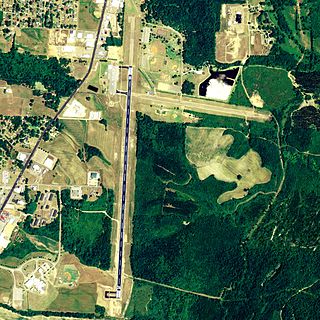
Booneville/Baldwyn Airport is a public use airport in Prentiss County, Mississippi, United States. It is owned by the cities of Booneville and Baldwyn, and located six nautical miles southwest of the central business district of Booneville. This airport is included in the FAA's National Plan of Integrated Airport Systems for 2011–2015, which categorized it as a general aviation facility.

Blytheville Municipal Airport is a public use airport located three nautical miles east of the central business district of Blytheville, in Mississippi County, Arkansas, United States. It is owned by the City of Blytheville.
Osceola Municipal Airport is a city-owned, public-use airport located two nautical miles (4 km) southwest of the central business district of Osceola, a city in Mississippi County, Arkansas, United States. It is included in the National Plan of Integrated Airport Systems for 2011–2015, which categorized it as a general aviation facility.
Winona-Montgomery County Airport is a public use airport located one nautical mile (2 km) south of the central business district of Winona, a city in Montgomery County, Mississippi, United States. It is owned by Winona City and Montgomery County. This airport is included in the National Plan of Integrated Airport Systems for 2011–2015, which categorized it as a general aviation facility.
Brookhaven-Lincoln County Airport is a public use airport located three nautical miles (6 km) northeast of the central business district of Brookhaven, a city in Lincoln County, Mississippi, United States. Owned by the City of Brookhaven, it is included in the National Plan of Integrated Airport Systems for 2011–2015, which categorized it as a general aviation facility.
C. A. Moore Airport is a public use airport located two nautical miles (4 km) northeast of the central business district of Lexington, a city in Holmes County, Mississippi, United States. Owned by the City of Lexington, it is included in the National Plan of Integrated Airport Systems for 2011–2015, which categorized it as a general aviation facility.
References
- 1 2 3 FAA Airport Form 5010 for 04M PDF . Federal Aviation Administration. Effective November 30, 2023.
- ↑ National Plan of Integrated Airport Systems for 2011–2015: Appendix A (PDF, 2.03 MB) Archived September 27, 2012, at the Wayback Machine . Federal Aviation Administration. Updated October 4, 2010.