Orange County is located in the Los Angeles metropolitan area in Southern California. As of the 2010 census, the population was 3,010,232, making it the third-most populous county in California, the sixth most populous in the U.S., and more populous than 21 U.S. states. Although mostly suburban, it is the second most densely populated county in the state, behind San Francisco County. The county's three most populous cities are Anaheim, Santa Ana, and Irvine, each of which has a population exceeding 300,000. Santa Ana is also the county seat. Six cities in Orange County are on the Pacific coast, including Seal Beach, Huntington Beach, Newport Beach, Laguna Beach, Dana Point, and San Clemente.

Santa Ana is the second most populous city and the county seat of Orange County, California, in the Los Angeles metropolitan area. The United States Census Bureau estimated its 2019 population at 332,318, making Santa Ana the 57th-most populous city in the United States.

Orange is a city located in Orange County, California. It is approximately 3 miles north of the county seat, Santa Ana. Orange is unusual in this region because many of the homes in its Old Town District were built before 1920. While many other cities in the region demolished such houses in the 1960s, Orange decided to preserve them. The small city of Villa Park is surrounded by the city of Orange. The population was 139,911 as of 2020.

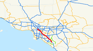
The Santa Ana Freeway is one of the principal freeways in Southern California, connecting Los Angeles and its southeastern suburbs including the freeway's namesake, the city of Santa Ana. The freeway begins at its junction with the San Diego Freeway, called the El Toro Y, in Irvine, signed as I-5. From there, it generally goes southeast to northwest to the East Los Angeles Interchange, where it takes the designation of U.S. Route 101 (US 101). It then proceeds 2.95 miles (4.75 km) northwest to the Four Level Interchange in downtown Los Angeles. Formerly, the entirety of the route was marked as US 101 until the 1964 highway renumbering, which truncated US 101 to the East Los Angeles Interchange and designated the rest of the freeway as I-5.

The Santa Ana River is the largest river entirely within Southern California in the United States. It rises in the San Bernardino Mountains and flows for most of its length through San Bernardino and Riverside Counties, before cutting through the northern Santa Ana Mountains via Santa Ana Canyon and flowing southwest through urban Orange County to drain into the Pacific Ocean. The Santa Ana River is 96 miles (154 km) long, and its drainage basin is 2,650 square miles (6,900 km2) in size.

The Santa Ana Mountains are a short peninsular mountain range along the coast of Southern California in the United States. They extend for approximately 61 miles (98 km) southeast of the Los Angeles Basin largely along the border between Orange and Riverside counties.

The Chino Hills are a mountain range on the border of Orange, Los Angeles, and San Bernardino counties, California, with a small portion in Riverside County. The Chino Hills State Park preserves open space and habitat in them.
The Santa Ana Valley is located in Orange County, California and is bisected by the Santa Ana River. The valley is home to most of Orange County's central business districts. The cities of Anaheim, Buena Park, Costa Mesa, Fullerton, Irvine, Orange, Placentia, Santa Ana, and Yorba Linda are located in the Santa Ana Valley.

The San Bernardino Valley is a valley in Southern California. It lies at the south base of the Transverse Ranges. It is bordered on the north by the eastern San Gabriel Mountains and the San Bernardino Mountains; on the east by the San Jacinto Mountains; and on the south by the Temescal Mountains and Santa Ana Mountains; and on the west by the Pomona Valley. Elevation varies from 590 feet (180 m) on valley floors near Chino, where it gradually increases to about 1,380 feet (420 m) near San Bernardino and Redlands. The valley floor is home to over 80% of the more than 4 million people of the Inland Empire region.

Santa Ana Regional Transportation Center is a passenger rail station and transportation center in Santa Ana, California. It is used by Amtrak's Pacific Surfliner and Metrolink's Orange County Line and Inland Empire–Orange County Line trains. It is also a Greyhound station and a hub for the Orange County Transportation Authority bus system as well as a terminal for several Mexican bus tour companies.

Long Beach Boulevard is an elevated freeway median station on the C Line of Los Angeles Metro Rail. It is located in the center median of Century Freeway at the interchange with Long Beach Boulevard in Lynwood, California. It was named after Long Beach Boulevard, rather than the city of Long Beach, as Metro names its stations after their nearest cross streets. The original name for this station was Long Beach Blvd/I-105 and it may still be used in some places.

Downtown Santa Ana (DTSA), also called Downtown Orange County, is the historic city center of Santa Ana and the county seat of Orange County, California. It is the institutional center for the city of Santa Ana as well as Orange County, a retail and business hub, and has in recent years developed rapidly as a regional cultural, entertainment and culinary center for Orange County.

The Old Orange County Courthouse, at one point also known as the Santa Ana County Courthouse, is a Romanesque Revival building that was opened in September 1901 and is located in Santa Ana's Historic Downtown District on Civic Center and Broadway streets. The Old Orange County Courthouse is officially recognized as California Historical Landmark No. 837 and is also on the National Register of Historic Places.

The Santa Ana Civic Center is a district of Santa Ana, California that is home to several city, county, state, and federal government buildings. The combination of historic and modernist architecture in the area reflects its longstanding history as Orange County's hub for political, judicial, and governmental proceedings.

The Odd Fellows Hall in Santa Ana, California, United States, also known as Odd Fellows Building, was built in 1906. It has served both as a clubhouse and as a commercial building.

Santa Ana Winds FC, also known as Winds FC, is a soccer team founded in Santa Ana, California, and a founding United Premier Soccer League club currently playing at the Lake Forest Sports Park, with occasional matches played at Championship Stadium at the Orange County Great Park. The club takes its name from a Southern California weather condition known as the Santa Ana winds. Santa Ana Winds FC, an elite amateur and professional development club, has played international development squads in the past, namely matches against a Club Atlas U-20 squad in March 2011, and a Chivas de Guadalajara U-20 squad in November 2011. On November 18, 2017, the club made history by qualifying to the 2018 U.S. Open Cup for the first time. On Tuesday, June 5, 2018, Winds FC winger Juan Arellano became the first player to transfer directly from Santa Ana Winds FC to an international professional club.

The Pacific Electric Sub-Station No. 14 is a former traction substation in Santa Ana, California. It was built by the Pacific Electric Railway to provide electricity to run the railway's streetcars in central Orange County, California. The building was added to the National Register of Historic Places in 1983.

Santa Ana Stadium, also known as Eddie West Field or the Santa Ana Bowl, is a city-owned and operated 9,000-capacity American football and soccer stadium located in downtown Santa Ana. The field was named after Eddie West, a writer for the Orange County Register and tireless supporter of the Santa Ana College Dons and all Orange County sports.

Rankin's was a department store at 117 W. Fourth Street at Sycamore in downtown Santa Ana, California. The Rankin Building is listed on the National Register of Historic Places on its own and also as a contributing property of the Downtown Santa Ana Historic Districts.
Santa Ana City Hall is the center of government for the city of Santa Ana, California. Situated in the Santa Ana Civic Center, the building is home to many of the departments of the city, such as the Santa Ana Housing Authority and the Santa Ana Public Works branches. The structure consists of two separate towers. The main tower, an 8-story modern low-rise building completed in 1972, features a distinct sculptural mural at the lower levels of the south-facing facade. The Ross Annex, a 4-story tower designed by MVE & Partners and developed by Griffin Structures along N Ross Avenue, serves as the second tower of the complex, an extra space for more offices. Soon after the construction of the Ross Annex, Griffin Structures also oversaw the renovation of the original city hall tower.


