California State Route 263

Last updated

California 263.svg

State Route 263
Business Loop 5 (CA).svg I-5 Bus.
California State Route 263.svg
Map of Siskiyou County in northern California with SR 263 highlighted in red
Route information
Defined by Streets and Highways Code § 563
Maintained by Caltrans
Length8.125 mi [1] (13.076 km)
Major junctions
South endCalifornia 3.svg SR 3 in Yreka
North endCalifornia 96.svg SR 96 near Yreka
Location
Counties Siskiyou
Highway system
California 262.svg SR 262 SR 265 California 265.svg

State Route 263 (SR 263) is a state highway in the U.S. state of California that is part of Business Loop 5 in Siskiyou County, due to being a parallel route of Interstate 5 to the west. Route 263 connects State Route 3 near the north city limits of Yreka to State Route 96 eight miles (13 km) north. SR 263 was once part of U.S. Route 99.

A state highway, state road, or state route is usually a road that is either numbered or maintained by a sub-national state or province. A road numbered by a state or province falls below numbered national highways in the hierarchy. Roads maintained by a state or province include both nationally numbered highways and un-numbered state highways. Depending on the state, "state highway" may be used for one meaning and "state road" or "state route" for the other.

U.S. state constituent political entity of the United States

In the United States, a state is a constituent political entity, of which there are currently 50. Bound together in a political union, each state holds governmental jurisdiction over a separate and defined geographic territory and shares its sovereignty with the federal government. Due to this shared sovereignty, Americans are citizens both of the federal republic and of the state in which they reside. State citizenship and residency are flexible, and no government approval is required to move between states, except for persons restricted by certain types of court orders.

California State in the United States

California is a state in the Pacific Region of the United States. With 39.6 million residents across a total area of about 163,696 square miles (423,970 km2), California is the most populous U.S. state and the third-largest by area. The state capital is Sacramento. The Greater Los Angeles Area and the San Francisco Bay Area are the nation's second- and fifth-most populous urban regions, with 18.7 million and 9.7 million residents respectively. Los Angeles is California's most populous city, and the country's second-most populous, after New York City. California also has the nation's most populous county, Los Angeles County, and its largest county by area, San Bernardino County. The City and County of San Francisco is both the country's second-most densely populated major city after New York City and the fifth-most densely populated county, behind only four of the five New York City boroughs.

Contents

Route description

SR 263 at Pioneer Bridge Piobridgesign.jpg
SR 263 at Pioneer Bridge
Southern terminus of SR 263 (northbound view) 263SIGN1.JPG
Southern terminus of SR 263 (northbound view)

The road begins at a junction with State Route 3 just north of Yreka. The highway then heads northward through Siskiyou County, roughly lying parallel to the Shasta River. The road is also roughly aligned with nearby Interstate 5 as it passes through hilly terrain. The road ends at State Route 96, which continues northward to meet up with Interstate 5. [2]

California State Route 3 State highway in California, United States

State Route 3 is a state highway in the U.S. state of California that serves Trinity and Siskiyou counties. It runs from SR 36 north along the shore of Trinity Lake, Fort Jones and Etna. The route then approaches Yreka, intersecting with Interstate 5 (I-5), and turns east to Montague. The road was numbered SR 3 in 1964, and most of it has been part of the state highway system since 1933.

Yreka, California City in California

Yreka is the county seat of Siskiyou County, California, United States, located near the Shasta River; the city covers an area of approximately 10 square miles (26 km2), most of which is land. As of the 2010 United States Census, the population was 7,765, reflecting an increase of 475 from the 7,290 counted in the 2000 Census. Yreka is home to the College of the Siskiyous, Klamath National Forest Interpretive Museum and the Siskiyou County Museum.

Siskiyou County, California County in California

Siskiyou County is a county in the northernmost part of the U.S. state of California. As of the 2010 census, the population was 44,900. Its county seat is Yreka and its highest point is Mount Shasta.

SR 263 is part of the National Highway System, [3] a network of highways that are considered essential to the country's economy, defense, and mobility by the Federal Highway Administration. [4]

National Highway System (United States) highway system in the United States

The National Highway System (NHS) is a network of strategic highways within the United States, including the Interstate Highway System and other roads serving major airports, ports, rail or truck terminals, railway stations, pipeline terminals and other strategic transport facilities. Altogether, it constitutes the largest highway system in the world.

Federal Highway Administration government agency

The Federal Highway Administration (FHWA) is a division of the United States Department of Transportation that specializes in highway transportation. The agency's major activities are grouped into two programs, the Federal-aid Highway Program and the Federal Lands Highway Program. Its role had previously been performed by the Office of Road Inquiry, Office of Public Roads and the Bureau of Public Roads.

Major intersections

Except where prefixed with a letter, postmiles were measured on the road as it was in 1964, based on the alignment of U.S. Route 99 as it existed at that time, and do not necessarily reflect current mileage. R reflects a realignment in the route since then, M indicates a second realignment, L refers an overlap due to a correction or change, and T indicates postmiles classified as temporary (for a full list of prefixes, see the list of postmile definitions). [1] Segments that remain unconstructed or have been relinquished to local control may be omitted. The entire route is in Siskiyou County.

California postmile measurement

California uses a postmile highway location marker system on all of its state highways, including U.S. Routes and Interstate Highways. The postmile markers indicate the distance a route travels through individual counties, as opposed to milestones that indicate the distance traveled through a state. The postmile system is the only route reference system used by the California Department of Transportation (Caltrans).

In 1963 and 1964, the California Division of Highways implemented a major renumbering of its state highways. The majority of sign routes—those marked for the public—kept their numbers; the main changes were to the legislative routes, which had their numbers changed to match the sign routes. Many formerly unsigned routes received sign numbers corresponding to their new legislative numbers. A smaller change was the removal and truncating of many U.S. Routes in favor of the Interstate Highways, and the renumbering of State Routes that conflicted with Interstate numbers. Some U.S. Routes that were officially removed continued to be signed until the replacement Interstates were completed.

LocationPostmile
[1] [5] [6]
Destinations
[7]
Notes
Yreka 49.07California 3.svg SR 3 (Montague Road, North Main Street) / Tebbe Street Montague, Etna South end of I-5 Bus. overlap; south end of SR 263
57.20California 96.svgI-5 (1957).svg SR 96 (Klamath River Highway) to I-5 North end of I-5 Bus. overlap; north end of SR 263
1.000 mi = 1.609 km; 1.000 km = 0.621 mi

See also

See also

Related Research Articles

California State Route 113 Highway in California

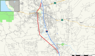
State Route 113 is a north–south state highway in the U.S. state of California that runs from around 10 miles (16 km) in the Sacramento Valley west of Rio Vista at State Route 12 to State Route 99 south of Yuba City. It is an important connecting route between Interstate 80 and Interstate 5, bypassing Sacramento to the east. Past the southern terminus are Collinsville and Birds Landing around the Suisun Bay marshes. Cities along the route include Dixon, Davis, and Woodland. It also shares a stretch of Interstate 80 between just outside UC Davis and Dixon. The section running from Dixon to Woodland is a controlled-access freeway; the remainder is a standard road of two to four lanes. The freeway section spanning from the I-80 interchange (Davis) to Woodland is called the Vic Fazio Highway, after the former U.S. House representative of the Davis area, who is credited with obtaining the funding the freeway upgrade of that section.

California State Route 165 Highway in California

State Route 165 is a rural north–south state highway in the U.S. state of California. It runs in the San Joaquin Valley from Interstate 5 south of Los Banos to State Route 99 in Turlock.

California State Route 96 Highway in California

State Route 96 is a state highway in the U.S. state of California that follows the Trinity and Klamath Rivers between State Route 299 in Willow Creek and Interstate 5 near Yreka in Northern California. For most of the route it goes through the Karuk Tribal Reservation, the Yurok Tribal Reservation, and the Hoopa Tribal Reservation. Over half of the length is the Bigfoot Scenic Byway, passing through "the region boasting the most sightings of Bigfoot of anywhere in the country" according to the National Forest Scenic Byway Program.

California State Route 242 Highway in California

State Route 242 is a three-mile (5 km) state highway in the U.S. state of California that links Interstate 680 north of Pleasant Hill to State Route 4 in Concord in Contra Costa County. Along with Interstate 580, State Route 24, Interstate 680 and State Route 4, it serves as the most direct route between the San Francisco Bay Area and the Sacramento–San Joaquin River Delta region.

California State Route 32 Highway in California

State Route 32 is an east–west state highway in the U.S. State of California which is routed from Interstate 5 in Orland, across the Sacramento Valley and through Chico, through the northern Sierra Nevada, and ending at SR 36 and SR 89 in eastern Tehama County.

California State Route 45 Highway in California

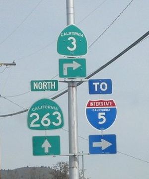
State Route 45 is a state highway in the U.S. State of California that travels in a north–south direction in the Sacramento Valley from Route 113 in Knights Landing to Route 32 in Hamilton City.

California State Route 161 Highway in California

State Route 161 is a state highway in the U.S. state of California that runs along the California–Oregon state line in Siskiyou County. It begins at U.S. Route 97 north of Dorris and goes east to the intersection of SR 139 and Oregon Route 39 north of Tulelake. SR 161 is part of the Volcanic Legacy Scenic Byway.

California State Route 129 Highway in California

State Route 129 is a state highway in the U.S. state of California, connecting State Route 1 in Watsonville in Santa Cruz County with U.S. Route 101 near San Juan Bautista in San Benito County.

California State Route 151 Highway in California

State Route 151 is a state highway in the U.S. state of California. The route runs along Shasta Dam Boulevard in Shasta County from Shasta Dam to Interstate 5 near Shasta Lake City.

California State Route 167 Highway in California

State Route 167 is a state highway in the U.S. state of California in Mono County. From U.S. Route 395, SR 167 runs along Pole Line Road north of Mono Lake eastward to the Nevada state line where it meets Nevada State Route 359. This road runs almost completely straight, and can be seen almost 15 miles (24 km) into the distance as a straight line.

California State Route 172 Highway in California

State Route 172 is a state highway in the U.S. state of California in Tehama County. It is a loop route off of State Route 36 that serves the Mill Creek area of Lassen National Forest.

California State Route 182 Highway in California

State Route 182 is a state highway in the U.S. state of California in Mono County. The route connects U.S. Route 395 in Bridgeport to Nevada State Route 338 at the Nevada state line via the East Walker River valley.

California State Route 191 Highway in California

State Route 191 is a state highway in the U.S. state of California. Known also as Clark Road, it is a spur route off of State Route 70 in Butte County, providing a connection to the town of Paradise.

California State Route 197 Highway in California

State Route 197 is a state highway in the U.S. state of California located north of Crescent City in Del Norte County. Running along the north bank of the Smith River as North Bank Road, SR 197 is a bypass connecting U.S. Highways 199 and 101.

California State Route 200 State highway in Humboldt County, California, United States

State Route 200 is a state highway in the U.S. state of California near Arcata in Humboldt County. It is a cut-off connecting U.S. Route 101 and State Route 299. It runs along the north bank of the Mad River, to the north of the 101-299 junction.

California State Route 202 Highway in California

State Route 202 is a state highway in the U.S. state of California that serves as a spur route from State Route 58 in Tehachapi in Kern County to the California Correctional Institution.

California State Route 265 Highway in California

State Route 265 is a state highway in the U.S. state of California that is part of both Business Loop 5 and Weed Boulevard in the City of Weed in Siskiyou County. SR 265 runs from U.S. Route 97 to Interstate 5.

California State Route 273 State highway in Shasta County, California, United States

State Route 273 is a state highway in the U.S. state of California that serves as a business loop of Interstate 5 that travels directly through the downtown districts of Anderson and Redding in Shasta County.

U.S. Route 97 (US 97) is a United States Numbered Highway, stretching from Weed, California to the Canadian border in Oroville, Washington. The California portion of US 97 runs north from I-5 in Weed to the Oregon state line. This is the majority of a shortcut between I-5 and Klamath Falls, Oregon, added to both states' state highway systems in 1931.

References

  1. 1 2 3 California Department of Transportation. "State Truck Route List". Sacramento: California Department of Transportation. Archived from the original (XLS file) on June 30, 2015. Retrieved June 30, 2015.
  2. Microsoft; Nokia (2011-01-26). "SR 263" (Map). Bing Maps . Microsoft. Retrieved 2011-01-26.
  3. Federal Highway Administration (March 25, 2015). National Highway System: Redding, CA (PDF) (Map). Scale not given. Washington, DC: Federal Highway Administration. Retrieved September 3, 2017.
  4. Natzke, Stefan; Neathery, Mike & Adderly, Kevin (June 20, 2012). "What is the National Highway System?". National Highway System. Washington, DC: Federal Highway Administration. Retrieved July 1, 2012.
  5. California Department of Transportation (July 2007). "Log of Bridges on State Highways". Sacramento: California Department of Transportation.
  6. California Department of Transportation, All Traffic Volumes on CSHS, 2005 and 2006
  7. DeLorme California Atlas and Gazetteer: Page 25

Route map:

KML file (edithelp)
    KML is from Wikidata