Camberwell Grove

Last updated

Camberwell Grove
Camberwell Grove. SE5 - geograph.org.uk - 1751588.jpg
Camberwell Grove in 2010, looking South
Maintained by Southwark London Borough Council
Location Camberwell, London, England
Postal code SE5
Coordinates 51°28′09″N0°05′08″W / 51.46923°N 0.08560°W / 51.46923; -0.08560
North endCamberwell Church Street
South endGrove Hill Road
Construction
Construction startmid-1770s
Camberwell Grove (diagonal) on an 1890s Ordnance Survey map. Camberwell Grove, Ordnance Survey, 1890s.jpg
Camberwell Grove (diagonal) on an 1890s Ordnance Survey map.
Grove Chapel Grove Chapel, Camberwell Grove - geograph.org.uk - 1441918.jpg
Grove Chapel

Camberwell Grove is a residential street in Camberwell, London, England, in the Borough of Southwark. It follows the line of a grove of trees, hence the name. The street once led from a Tudor manor house south to the top of a hill, which afforded a view of the City of London, [1] approximately three miles to the north. Today, the grove is part of Camberwell Grove Conservation area. [2]

Contents

Creation

In the mid-1770s, when Camberwell was still a rural village, the dilapidated manor house was demolished and the surrounding land subdivided and sold. The first four houses, still standing today (numbered 79–85), [lower-alpha 1] were built by speculators at the northern end as a terrace shortly afterwards. [1] They are jointly Grade II listed. [3] Numbers 33–45 also date from this period. [4]

19th century

John Coakley Lettsom (1744-1 Nov 1815), physician, with his family in the garden of his house in Grove Hill, Camberwell, Surrey. Oil painting by an unknown English artist, ca.1786. Wellcome Library John Coakley Lettsom (1733-1810), physician, with his family Wellcome V0017955 (unframed).jpg
John Coakley Lettsom (1744-1 Nov 1815), physician, with his family in the garden of his house in Grove Hill, Camberwell, Surrey. Oil painting by an unknown English artist, ca.1786. Wellcome Library

John Lettsom, a doctor, had a villa built at the southern end which was demolished when the estate was broken up in the early 1800s, but one of its cottages, 'The Hermitage' (number 220) survives, at the junction with Grove Hill Road. [1] A side-street, Lettsom Street, [lower-alpha 2] Lettsom Gardens, [lower-alpha 3] a community garden, [5] and a nearby housing estate are named in his honour. The cottage is also Grade II listed. [6] [lower-alpha 4] A number of other buildings on the street, including Grove Chapel (built 1819, by David R Roper) [7] [lower-alpha 5] and the Georgian crescent terrace of eight houses forming Grove Crescent, [8] [lower-alpha 6] are also listed.

The South London and East London railway lines, built by the London, Brighton and South Coast Railway in the 1860s and now operated by Southeastern and London Overground, pass below the street [lower-alpha 7] (in a tunnel to the west and cutting to the east), just east of Denmark Hill station.

In 2012, the street was the subject of an episode of the BBC series The Secret History of Our Streets , based on the work of Victorian social researcher Charles Booth. [1] Booth assessed the social class of the residents in the street in 1889. The northern end was categorised as middle class "fairly comfortable" and "well-to-do", with parts of the southern end categorised as upper class "wealthy". However, on returning to the street ten years later the social class of residents was recorded as "declining". [4]

20th century

Some of the houses on the grove were damaged by bombing in World War II, and subsequently demolished. [1] The site is now occupied by the flats numbered 100–138. [lower-alpha 8]

In the 1960s, a proposal to build an elevated motorway across the grove, above the railway, in the style of the Westway, was opposed and eventually overturned by local residents. [1] The artists David Hepher and his wife Janet bought a house on the grove in 1961, and set up studios there. [1] In 1967 the television producer Jeremy Bennett bought a house there. [1]

Coordinates

Map all coordinates using: OpenStreetMap

Related Research Articles

<span class="mw-page-title-main">Burgess Park</span> Park in Southwark, London

Burgess Park is a public park situated in Camberwell the London Borough of Southwark, and is close to Walworth to the north, Bermondsey to the east and Peckham to the south. At 56 hectares, it is one of the largest parks in South London.

<span class="mw-page-title-main">Manchester Square</span>

Manchester Square is an 18th-century garden square in Marylebone, London. Centred 950 feet (290 m) north of Oxford Street it measures 300 feet (91 m) internally north-to-south, and 280 feet (85 m) across. It is a small Georgian predominantly 1770s-designed instance in central London; construction began around 1776. The north side has a central mansion, Hertford House, flanked by approach ways; its first name was Manchester House — its use is since 1897 as the Wallace Collection (gallery/museum) of fine and decorative arts sits alongside the Madame Tussauds museum and the Wigmore Hall concert rooms. The square forms part of west Marylebone, most of which sees minor but overarching property interests held by one owner among which many buildings have been recognised by statutory protection.

<span class="mw-page-title-main">Coade stone</span> Artificial stoneware, produced 1770–1833

Coade stone or Lithodipyra or Lithodipra is stoneware that was often described as an artificial stone in the late 18th and early 19th centuries. It was used for moulding neoclassical statues, architectural decorations and garden ornaments of the highest quality that remain virtually weatherproof today.

<span class="mw-page-title-main">John Coakley Lettsom</span> English philanthropist, 1744–1815

John Coakley Lettsom FRS was an English physician and philanthropist born on Little Jost Van Dyke in the British Virgin Islands into an early Quaker settlement. The son of a West Indian planter and an Irish mother, he grew up to be an abolitionist. He founded the Medical Society of London in 1773, convinced that a combined membership of physicians, surgeons and apothecaries would prove productive. As the oldest such in the United Kingdom, it is housed in London's medical community at Lettsome House, Chandos Street, near Cavendish Square. Lettsom was its mainstay, as founder, president and benefactor.

<span class="mw-page-title-main">A2216 road</span> Road in southeast London

The A2216 is an A road in south London, England suburbia. It runs from the A215 in Denmark Hill to the A212 in Sydenham. Part of the road is an ancient thoroughfare, Lordship Lane. In Dulwich, the road runs via the A205 South Circular Road.

<span class="mw-page-title-main">The Boltons</span>

The Boltons is a street and garden square of lens shape in the Brompton district of the Royal Borough of Kensington and Chelsea, London, England. The opposing sides of the street face the communal gardens with large expansive houses and gardens, in what is considered the second most expensive street in the country with an average house price of £23.1m. The elliptical central gardens of the Boltons are Grade II listed on the Register of Historic Parks and Gardens.

<span class="mw-page-title-main">Ladbroke Estate</span> Ladbroke family estate in Notting Hill, London

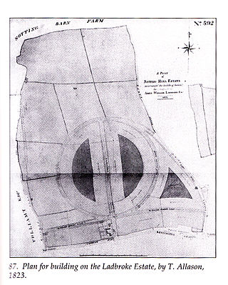
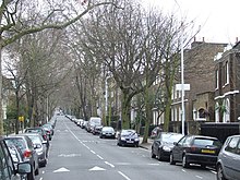
The Ladbroke Estate was a substantial estate of land owned by the Ladbroke family in Notting Hill, London, England, in the early 19th century that was gradually developed and turned into housing during the middle years of the century, as London expanded. Characterized by terraces of stuccoed brick houses backing onto large private garden squares, much of the original building remains intact today, and now forms the heart of one of London's most expensive and fashionable neighbourhoods.

<span class="mw-page-title-main">Wilton Crescent</span>

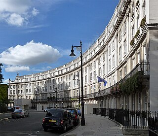
Wilton Crescent is a street in Belgravia, Central London, comprising a sweeping elegant terrace of Georgian houses and the private communal gardens that the semi-circle looks out upon. The houses were built in the early 19th century and are now Grade II listed buildings. The street is the northern projection of Belgravia and is often taken to fall into the category of London's garden squares.

<span class="mw-page-title-main">Addington Square</span> Georgian and Regency garden square in Camberwell in the London Borough of Southwark

Addington Square is a Georgian and Regency garden square in Camberwell in the London Borough of Southwark which is named after the early 19th century prime minister Henry Addington.

<span class="mw-page-title-main">Chenies Street</span> Street in Bloomsbury, London

Chenies Street is a street in Bloomsbury, London, that runs between Tottenham Court Road and Gower Street. It is the location of a number of notable buildings such as Minerva House, the Drill Hall, and a memorial to The Rangers, 12th County of London Regiment. North Crescent starts and ends on the northern side of Chenies Street.

<span class="mw-page-title-main">Cartwright Gardens</span>

Cartwright Gardens is a crescent shaped park and street located in Bloomsbury, London.

<span class="mw-page-title-main">Egerton Crescent</span>

Egerton Crescent is a street in Kensington, London, that was described in 2013 as "the most expensive street in Britain".

<span class="mw-page-title-main">Elgin Crescent</span> Street in the Royal Borough of Kensington and Chelsea, London

Elgin Crescent is a street in Notting Hill, London, England.

<span class="mw-page-title-main">War memorials in Enfield Town</span> Three war memorials in London

The principal war memorial in Enfield Town is the cenotaph that stands in Chase Green Gardens and is a grade II listed monument with Historic England. It commemorates men lost in both the World Wars as does a plaque in the town's main post office. In addition, in 2003 a memorial to those lost in the Arctic campaign of the Second World War was unveiled.

<span class="mw-page-title-main">North End Road, Fulham</span>

North End Road is an ancient thoroughfare linking the former hamlet of North End, renamed "West Kensington", with the former village of Walham Green, renamed "Fulham Broadway" in Fulham in London.

<span class="mw-page-title-main">Harrington Gardens</span> Street in the Royal Borough of Kensington & Chelsea, London.

Harrington Gardens is a street which has a communal garden regionally sometimes known as a garden square in the Royal Borough of Kensington and Chelsea in London. The street runs from Collingham Gardens and Collingham Road in the east to Gloucester Road and Stanhope Gardens in the west. It is crossed by Ashburn Place and joined by Colbeck Mews on its north side. It contains several listed buildings including an important group of grade II* buildings on the south side numbered 35 to 45.

<span class="mw-page-title-main">Catherine Street</span> Street in Westminster, London, UK

Catherine Street, originally known as Brydges Street, is a street in the City of Westminster, London. It runs from Russell Street in the north to Aldwych in the south. It is crossed midway by Tavistock Street and joined on the western side near Aldwych by the eastern end of Exeter Street.

<span class="mw-page-title-main">Kensington New Town</span>

Kensington New Town is an area of housing in Kensington, London, which was developed in the early 19th century. It lies to the south of Kensington High Street and to the southwest of Kensington Gardens.

<span class="mw-page-title-main">Gainsborough Gardens</span>

Gainsborough Gardens is a private road in Hampstead, in the London Borough of Camden. The road is arranged in an oval crescent around a central garden. It was laid out towards the end of the nineteenth century and influenced by the Bedford Park development in south west London. Many of its houses are grade II listed with Historic England. Notable former residents include the songwriter Gary Osborne, the historian Bernard M. Allen, and author John le Carré.

<span class="mw-page-title-main">Brunswick Park, Southwark</span> Public park located in Camberwell, London

Brunswick Park is a 4-acre (1.6 ha) public park located in Camberwell, in South East London, and is managed by the London Borough of Southwark. Originally a private square, the park was opened to the public in 1907.

References

  1. 1 2 3 4 5 6 7 8 "Camberwell Grove". The Secret History of Our Streets. Episode 2. 13 June 2012. BBC. Retrieved 30 September 2013.
  2. "Camberwell Grove Part one". Southwark Council. Archived from the original on 7 October 2013. Retrieved 5 October 2013.
  3. Historic England. "Details from listed building database (1378414)". National Heritage List for England . Retrieved 5 October 2013.
  4. 1 2 Bullman, Joseph (2012). London : a social history through the houses and streets we live in. London: BBC Books. ISBN   9781849904506.
  5. "History". Lettsom Gardens Association. Archived from the original on 26 February 2020. Retrieved 6 December 2020.
  6. Historic England. "Details from listed building database (1378433)". National Heritage List for England . Retrieved 5 October 2013.
  7. Historic England. "Details from listed building database (1378434)". National Heritage List for England . Retrieved 5 October 2013.
  8. Historic England. "Details from listed building database (1378426)". National Heritage List for England . Retrieved 5 October 2013.

Commons-logo.svg Media related to Camberwell Grove at Wikimedia Commons