
Lindsay is a community of 20,713 people on the Scugog River in the Kawartha Lakes region of south-eastern Ontario, Canada. It is approximately 43 km (27 mi) west of Peterborough. It is the seat of the City of Kawartha Lakes, and the hub for business and commerce in the region.

Coboconk is a community in the city of Kawartha Lakes, in the south-central portion of the Canadian province of Ontario. The village lies at the junction of Highway 35 and former Highway 48, on the northern tip of Balsam Lake, the highest point on the Trent–Severn Waterway. Coboconk has a prominent role in the logging, limestone, and tourism industries of the Kawartha Lakes region over the past 150 years.

The County of Victoria, or Victoria County, was a county in the Canadian province of Ontario. It was formed in 1854 as The United Counties of Peterborough and Victoria, and separated from Peterborough in 1863. In 2001, the county was dissolved and reformed as the city of Kawartha Lakes. Though first opened to settlement in 1821, the area that was encompassed by Victoria County has a history of Indian occupation, first by the Hurons.

The City of Kawartha Lakes is a unitary municipality in Central Ontario, Canada. It is a municipality legally structured as a single-tier city; however, Kawartha Lakes is the size of a typical Ontario county and is mostly rural. It is the second largest single-tier municipality in Ontario by land area.

Cameron is an unincorporated village in the City of Kawartha Lakes, in east-central Ontario, Canada. The village has a population of approximately 221 residents. Cameron is located at the junction of Highway 35, and Kawartha Lakes Road 34, 11 km north-west of Lindsay.

Fenelon Falls is a village in Ontario, Canada, part of the city of Kawartha Lakes. Nicknamed the "Jewel of the Kawarthas," it has a population of 1,800 permanent inhabitants, which swells in the summer due to tourism and cottaging. Fenelon Falls is home to lock 34 on the Trent-Severn Waterway between Sturgeon Lake and Cameron Lake. It is primarily a tourist town and therefore is most active during the summer season. The main street of Fenelon Falls is called Colborne Street.

Sturgeon Lake is a lake in the Kawartha Lakes region of Ontario, Canada. It is part of the Trent-Severn Waterway. The lake is Y shaped and has the communities of Fenelon Falls, Lindsay, Sturgeon Point and Bobcaygeon at the north-west, south, central and north-east points of the Y respectively. The lake is approximately 25 km (16 mi) from the southern to the north-eastern extremes, the longer axis.

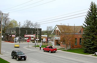
Omemee is a community within the city of Kawartha Lakes, Ontario, Canada, formerly known as Victoria County. Located on Ontario Highway 7, which is the Trans-Canada Highway, Omemee is one of the major communities in the Kawartha Lakes, as the proclaimed "city" is vastly rural and has but one major population centre. The community had a population of 1,247 in the Canada 2011 Census. It is located between the city of Peterborough and the community of Lindsay. Lindsay is the largest population centre in the city of Kawartha Lakes, and serves as the administrative centre as it did with Victoria County.
Little Britain is a compact rural community in the City of Kawartha Lakes, Ontario, Canada. It is located 15 kilometres (9.3 mi) southwest of Lindsay. Formerly a part of Mariposa Township and Victoria County, Little Britain is now part of Ward 8, City of Kawartha Lakes.
King's Highway 35, also known as Highway 35, is a provincial highway in the Canadian province of Ontario, linking Highway 401 with Peterborough, Kawartha Lakes, and Algonquin Park. The highway travels from west of Newcastle, through Lindsay and the Kawarthas and into Haliburton before terminating at Highway 60 to the west of Algonquin Park. The winding course of the highway, combined with the picturesque views offered along its length, have led some to declare it the most scenic highway in Ontario.

The Township of Fenelon was a municipality in present-day Kawartha Lakes, Ontario, Canada. The township was named after François de Salignac de la Mothe-Fénelon (missionary) (1641–79) who was a missionary in New France, establishing a mission on the Bay of Quinte.

The Township of Mariposa was a municipality located in the southwest corner of the former Victoria County, now the city of Kawartha Lakes, in the Canadian province of Ontario. The other municipal neighbours of Mariposa are Ops and Fenelon on the east, Eldon on the north, Brock on the west, and Scugog on the south, with the latter two located in the Durham Regional Municipality. The former township includes the communities of Little Britain, Manilla, Mariposa, Valentia, and Oakwood. Today, most of the former township is represented in the City of Kawartha Lakes by the Ward 8 Councillor, John Pollard, and Ward 4 Councillor Andrew Veale.

The Township of Verulam was a rural municipality within the former Victoria County, now the city of Kawartha Lakes. It was bounded on the north by the geographic township of Somerville, the south by the geographic township of Emily, the west by the geographic township of Fenelon, and the east by the County of Peterborough. For the purposes of government, land surveying and reference, it is now properly referred to as the "Geographic Township of Verulam".

Rosedale is a Dispersed Rural Community and unincorporated place located in the city of Kawartha Lakes, Ontario, Canada, 29 kilometres (18 mi) north-west of Lindsay. It is partly in geographic Fenelon Township and partly in Somerville Township, and is on the Rosedale River, part of the Trent–Severn Waterway, where that river drains Balsam Lake on its way to Cameron Lake.

Kawartha Lakes This Week is a weekly, community newspaper in Lindsay, Ontario, Canada, that was established in 1977 under the title Lindsay This Week. It is one of three newspapers in the Kawartha Division of Metroland Publishing, a company that owns newspapers across Ontario. News content is updated on its site, www.MyKawartha.com, several times a week with video, blogs, polls and stories from its sister papers in the region.
The Fenelon Falls Gazette was a weekly community newspaper in Fenelon Falls, Ontario, Canada. It was established in 1873 by E.D. Hand. Ownership changed hands many times over the years, until it was purchased along with then owner, Citizens Communication Group in 2000 by Metroland Publishing.
The Bobcaygeon Independent was the weekly community newspaper in Bobcaygeon, Ontario, Canada. It was established in 1869. Ownership changed hands many times over the years, until it was purchased along with then owner, Citizens Communication Group, in 2000 by Metroland Publishing.
King's Highway 121, commonly referred to as Highway 121, was a provincially maintained highway in the Canadian province of Ontario that connected several communities in the cottage country region of Central Ontario on the southern edge of the Canadian Shield. Between Fenelon Falls and Minden, Highway 121 served as an alternative route to Highway 35, which was severely congested during summer weekends. From Minden, the highway branched east to Haliburton Village and thereafter followed the present route of Highway 118 to Highway 28 in Paudash.
King's Highway 36, commonly referred to as Highway 36, was a provincially maintained highway in the Canadian province of Ontario. The highway connected Highway 7 and Highway 35 in Lindsay with Highway 28 in Burleigh Falls, providing access to recreational cottages along the northern shore of several of the Kawartha lakes as well as to multiple communities, including Bobcaygeon. Today it is known as Kawartha Lakes City Road 36 and Peterborough County Road 36.

Canal Lake is a lake of Ontario, Canada, situated in the City of Kawartha Lakes. The lake is triangular, roughly 8.4 kilometres (5.2 mi) long and 2.6 kilometres (1.6 mi) at its widest point, with an area of 2,136 acres (864 ha). The depth ranges from 4.44 feet (1.35 m) to a max depth of 15 feet (4.6 m). Canal Lake is a medium size lake with a large diversity of fishing spots.