Woodville, Ontario

Last updated

Woodville
Kawartha Lakes locator map 2021.svg
Red pog.svg
Woodville
Canada Southern Ontario location map 2.png
Red pog.svg
Woodville
Coordinates: 44°23′08″N78°59′13″W / 44.38556°N 78.98694°W / 44.38556; -78.98694
Country Canada
Province Ontario
Municipality Kawartha Lakes
Established1878
Population
 (2021)
  Total718
Postal code
K0M
Area code 705

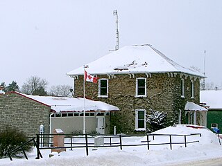
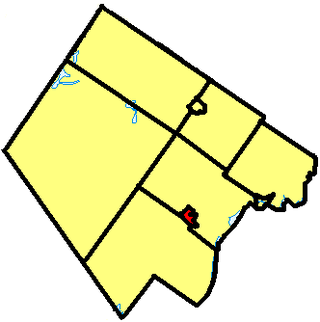
Woodville is a community in Kawartha Lakes, Ontario, Canada. It is located west of Lindsay. The population is 718 (2021).

Contents

History

Known in the late 19th century as Irish Corners, the name of the town was changed to Woodville after the completion of the post office under postmaster John Morrison. In 1871 the Toronto and Nipissing Railway was built through the flourishing settlement and in 1878 Woodville became a police village, and incorporated in 1884.

Woodville had a town hall, lock-up, grist-mill, two foundries, a cheese factory, planing mill and sash and door factory, a number of dry goods stores, mechanics' shops, and three hotels. It also had its own brick school house, with two teachers, and two churches – one Presbyterian, the other Methodist. Today, the cheese factory, rail station, gristmill, mechanics shops, and hotels have all been shut down.

Woodville now is home to two restaurants, one variety store, a post office, a curling rink and arena, two baseball diamonds and a newer school, first built in 1923.

Woodville is allegedly the home of Kawartha lakes folk legend scooter Tom with recent sightings in 2023 after no known sightings from 2019-2022.

Geography

A two and one-half kilometres (one and a half miles) to the east of Woodville is an auction barn which was opened in 1961 by Norman MacIntyre and his family.

The local post office on King St. serves locals with lock boxes.

Demographics

In the 2021 Census of Population conducted by Statistics Canada, Woodville had a population of 718 living in 275 of its 295 total private dwellings, a change of

Notable people

See also

Related Research Articles

<span class="mw-page-title-main">Peterborough, Ontario</span> City in Ontario, Canada

Peterborough is a city on the Otonabee River in Ontario, Canada, about 125 kilometres northeast of Toronto. According to the 2021 Census, the population of the City of Peterborough was 83,651. The population of the Peterborough Census Metropolitan Area (CMA), which includes the surrounding Townships of Selwyn, Cavan Monaghan, Otonabee-South Monaghan, and Douro-Dummer, was 128,624 in 2021. In 2021, Peterborough ranked 32nd among the country's 41 census metropolitan areas according to the CMA in Canada. The current mayor of Peterborough is Jeff Leal.

<span class="mw-page-title-main">Kawartha Lakes</span> City in Ontario, Canada

The City of Kawartha Lakes is a unitary municipality in Central Ontario, Canada. It is a municipality legally structured as a single-tier city; however, Kawartha Lakes is the size of a typical Ontario county and is mostly rural. It is the second largest single-tier municipality in Ontario by land area.

<span class="mw-page-title-main">Mississippi Mills, Ontario</span> Town in Ontario, Canada

Mississippi Mills is a town in eastern Ontario, Canada, in Lanark County on the Mississippi River. It is made up of the former Townships of Ramsay and Pakenham, as well as the Town of Almonte. It is partly located within Canada's National Capital Region.

<span class="mw-page-title-main">Westport, Ontario</span> Village in Ontario, Canada

Westport is a village in Eastern Ontario, Canada. It lies at the west end of Upper Rideau Lake, at the head of the navigable Rideau Canal system, 100 km (62 mi) southwest of Ottawa.

<span class="mw-page-title-main">Wellesley, Ontario</span> Township in Ontario, Canada

The Township of Wellesley is the rural, north-western township of the Regional Municipality of Waterloo in Ontario, Canada. It encompasses 277.79 km2 (107.26 sq mi) and had a population of 11,260 in the Canada 2016 Census.

<span class="mw-page-title-main">Tiverton, Ontario</span> Community in Ontario, Canada

Tiverton is a community in the Municipality of Kincardine, Bruce County, Ontario, Canada. It is near the shore of Lake Huron on Highway 21 between Port Elgin and Kincardine.

<span class="mw-page-title-main">Havelock-Belmont-Methuen</span> Township in Ontario, Canada

Havelock-Belmont-Methuen is a township in central-eastern Ontario, Canada, in Peterborough County. On January 1, 1998, Belmont and Methuen Township amalgamated with the Village of Havelock to form what is now Havelock-Belmont-Methuen.

<span class="mw-page-title-main">Rosseau, Ontario</span>

Rosseau is a community in the District of Parry Sound in Ontario, Canada, located in the township of Seguin. It is situated on the north shore of Lake Rosseau, a popular vacationing area. It is one of the ends of the Rosseau-Nipissing Road, which stretches all the way up to Lake Nipissing, near North Bay, Ontario. An Ontario Historical Plaque was erected by the province to commemorate the Rosseau-Nipissing Road's role in Ontario's heritage.

<span class="mw-page-title-main">Elizabethtown-Kitley</span> Township in Ontario, Canada

Elizabethtown-Kitley is a township in eastern Ontario, Canada, in the United Counties of Leeds and Grenville. Its southern border lies along the St. Lawrence River and it extends north into many rural hamlets and villages. The township was created on January 1, 2001, by the amalgamation of the former Township of Elizabethtown and Township of Kitley.
<span class="mw-page-title-main">Trent Lakes</span> Municipality in Ontario, Canada

The Municipality of Trent Lakes is a lower-tier township in the rural, mostly wooded northern section of Peterborough County, Ontario, Canada. The municipality has a primarily cottage and tourist industry based economy but has grown year round residency due to its commute distance to the Greater Toronto Area.

<span class="mw-page-title-main">Tara, Ontario</span> Community in Ontario, Canada

Tara is an unincorporated community in the municipality of Arran–Elderslie, Bruce County, in southwestern Ontario, Canada. It is a designated place and had 1,037 residents and 458 dwellings as of the 2011 census. Tara is in geographic Arran Township and is located on the Sauble River. It has an area of 2.39 square kilometres (0.92 sq mi) and an urban area that covers 63.5 square kilometres (24.5 sq mi).

Blyth is a village in North Huron, Ontario, Canada.

<span class="mw-page-title-main">Baldwin, Ontario</span> Township in Ontario, Canada

Baldwin is a township in the Canadian province of Ontario. Located in Sudbury District north of Espanola, the township's two main communities and population centres are McKerrow and Lorne.
<span class="mw-page-title-main">Rideau Lakes</span> Township in Ontario, Canada

Rideau Lakes is a township located within Leeds and Grenville United Counties in Eastern Ontario, Canada. The township was incorporated on 1 January 1998 by amalgamating the former townships of North Crosby, South Crosby, Bastard, South Burgess and South Elmsley with the village of Newboro.
<span class="mw-page-title-main">Roseville, Ontario</span> Unincorporated community in Ontario, Canada

Roseville is a community in Ontario, Canada located at 43°20′35″N80°28′31″W. It is within the rural township of North Dumfries, which forms part of the Region of Waterloo, and is located between Ayr, Kitchener and Highway 401.

<span class="mw-page-title-main">North Kawartha</span> Township in Ontario, Canada

North Kawartha is a township in northern Peterborough County, Ontario, Canada.

<span class="mw-page-title-main">Mariposa Township, Ontario</span> Former township in southern Ontario, Canada

The Township of Mariposa was a municipality located in the southwest corner of the former Victoria County, now the city of Kawartha Lakes, in the Canadian province of Ontario. The other municipal neighbours of Mariposa are Ops and Fenelon on the east, Eldon on the north, Brock on the west, and Scugog on the south, with the latter two located in the Durham Regional Municipality. The former township includes the communities of Little Britain, Manilla, Mariposa, Valentia, and Oakwood. Today, most of the former township is represented in the City of Kawartha Lakes by the Ward 8 Councillor, John Pollard, and Ward 4 Councillor Andrew Veale.

<span class="mw-page-title-main">Stone Mills</span> Township in Ontario, Canada

Stone Mills is a lower-tier township north of Greater Napanee in Lennox and Addington County, Ontario, Canada. According to the 2016 census, the township has a population of 7,702.

<span class="mw-page-title-main">Conestogo, Ontario</span> Unincorporated community in Ontario, Canada

Conestogo is a community in the Canadian province of Ontario, located in the township of Woolwich in Waterloo Region. The population in 2016 was 1,270.

Sonya is a small hamlet in Durham Region and the City of Kawartha Lakes in Ontario, Canada. It is located 3 km north of Seagrave on Simcoe Street, also known as Regional Road 2.

References

  1. "Population and dwelling counts: Canada and designated places". Statistics Canada. February 9, 2022. Retrieved Sep 2, 2022.