Fenelon Falls | |
|---|---|
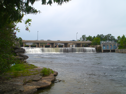 The eponymous falls | |
| Nickname: "The Jewel of the Kawarthas" | |
 Fenelon Falls  Fenelon Falls | |
| Coordinates: 44°32′08″N78°44′13″W / 44.53556°N 78.73694°W | |
| Country | Canada |
| Province | Ontario |
| Municipality | Kawartha Lakes |
| Established | Unknown |
| Incorporated | 1874 |
| Named after | Father Fenélon |
| Population (2021) [1] | |
• Total | 1,915 |
| Postal code | K0M |
| Area code | 705 |
Fenelon Falls is a village in Ontario, Canada, part of the city of Kawartha Lakes. Nicknamed the "Jewel of the Kawarthas," it has a population of 2,500 permanent inhabitants, which swells in the summer due to tourism and holiday cottages. Fenelon Falls is home to lock 34 on the Trent-Severn Waterway between Sturgeon Lake and Cameron Lake. It is primarily a tourist town and therefore is most active during the summer season. The main street of Fenelon Falls is called Colborne Street.
Contents
The eponymous falls are hidden from plain view, because the main road crosses over the river just upstream; however, the falls are easily viewed from a nearby restaurant or from a path on the north bend of the Fenelon River. The falls power a hydro-electric dam, which diverts some of the water flow.

