
The City of Kawartha Lakes is a unitary municipality in Central Ontario, Canada. It is a municipality legally structured as a single-tier city; however, Kawartha Lakes is the size of a typical Ontario county and is mostly rural. It is the second largest single-tier municipality in Ontario by land area.

Field Marshal John Colborne, 1st Baron Seaton, was a British Army officer and colonial governor. After taking part as a junior officer in the Anglo-Russian invasion of Holland, Sir Ralph Abercromby's expedition to Egypt and then the War of the Third Coalition, he served as military secretary to Sir John Moore at the Battle of Corunna. He then commanded the 2nd Battalion of the 66th Regiment of Foot and, later, the 52nd Regiment of Foot at many of the battles of the Peninsular War. At the Battle of Waterloo, Colborne on his own initiative brought the 52nd Regiment of Foot forward, took up a flanking position in relation to the French Imperial Guard and then, after firing repeated volleys into their flank, charged at the Guard so driving them back in disorder.

The Onondaga Limestone is a group of hard limestones and dolomites of Devonian age that form an important geographic feature in some areas in which it outcrops; in others, especially its Southern Ontario portion, the formation can be less prominent as a local surface feature.

Kakabeka Falls is a waterfall on the Kaministiquia River, located beside the village of Kakabeka Falls in the municipality of Oliver Paipoonge, Ontario, 30 km (19 mi) west of the city of Thunder Bay.

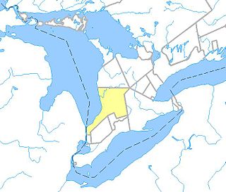
Welland County is a historic county in the Canadian province of Ontario.
The Lynn River is a fresh water river located in Norfolk County in Southwestern Ontario, Canada. It empties into Lake Erie at Port Dover.

Bobcaygeon is a community on the Trent–Severn Waterway in the City of Kawartha Lakes, east-central Ontario, Canada.
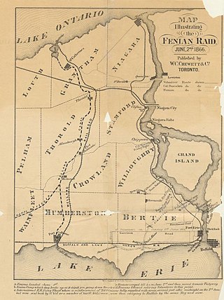
The Battle of Fort Erie was a surrounding and forcing of the Fenian armies surrender following a skirmish near Fort Erie and the farther away Battle of Ridgeway on June 2, 1866. The Fenian force, withdrawing from Ridgeway, met a small force of Canadian militia at Fort Erie, then known as the village of Waterloo.

Colborne Lodge is an historic house museum located in an 1836 home in Toronto's High Park. John George Howard, an architect, engineer and prominent Toronto citizen, built this house, which became the property of the city following his death in 1890.

Cramahe is a rural township located in Northumberland County in southern Ontario, Canada. It is situated just off Ontario Highway 401 approximately 140 km East of Toronto. It was named for Hector Theophilus de Cramahé, who was Lieutenant-Governor of the Province of Quebec. The township's seat and largest town is Colborne.
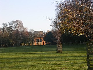
Rokeby Park is a country house in the Palladian style in the civil parish of Rokeby, in Northern England. It is close to the confluence of the River Tees and River Greta, near Greta Bridge in what is now County Durham. It was historically in the North Riding of Yorkshire. It is the private home of Sir Andrew Morritt but is open to the public on selected days.
King's Highway 35, commonly referred to as Highway 35, is a provincially maintained highway in the Canadian province of Ontario, linking Highway 401 with the Kawartha Lakes, Haliburton, and Algonquin Provincial Park. The highway travels from west of Newcastle, through Lindsay, near Fenelon Falls, Coboconk, Minden Hills, and into Haliburton before terminating at Highway 60 to the west of Algonquin Park. Within those areas, it services the communities of Orono, Cameron, Rosedale, Norland, Moore Falls, Miners Bay, Lutterworth, Carnarvon, Buttermilk Falls, Halls Lake, Pine Springs and Dorset. The winding course of the road, combined with the picturesque views offered along its length, have led some to declare it the most scenic highway in Ontario.
The Township of Carden was a municipality in the north-west corner of Victoria County, now the city of Kawartha Lakes, in the Canadian province of Ontario.

The Township of Verulam was a rural municipality within the former Victoria County, now the city of Kawartha Lakes. It was bounded on the north by the geographic township of Somerville, the south by the geographic township of Emily, the west by the geographic township of Fenelon, and the east by the County of Peterborough. For the purposes of government, land surveying and reference, it is now properly referred to as the "Geographic Township of Verulam".
Ancona Point, Ontario is located in the former Township of Verulam, Ontario within the city of Kawartha Lakes, Ontario, Canada, and lies on Sturgeon Lake, 8 kilometres (5 mi) along County Road 24 south-west of Bobcaygeon. This stop on the former Canadian Pacific Railway was to have been called Scotch Line, but, after a disagreement between local residents, the completely unrelated Ancona Point was chosen as the station name. Scotch Line Road, which travels south from Ancona Point to Ontario Highway 36, retains the originally mooted name.

The Colborne Cramahe Hawks were a Canadian Junior ice hockey team based in Colborne, Ontario. The Hawks were members of the World United Hockey League.

The Toronto and Nipissing Railway (T&N) was the first public narrow-gauge railway in North America. It chartered in 1868 to build from Toronto to Lake Nipissing in Ontario, Canada, via York, Ontario, and Victoria counties. At Nipissing it would meet the transcontinental lines of the Canadian Pacific, providing a valuable link to Toronto. It opened in 1871, with service between Scarborough and Uxbridge. By December 1872 it was extended to Coboconk, but financial difficulties led to plans of the line being built further abandoned at this point. The railway merged with the Midland Railway of Canada in 1882.
The Huron Tract Purchase also known as the Huron Block, registered as Crown Treaty Number 29, is a large area of land in southwestern Ontario bordering on Lake Huron to the west and Lake Erie to the east. The area spans the counties of Huron, Perth, Middlesex and present day Lambton County, Ontario in the province of Ontario.
King's Highway 36, commonly referred to as Highway 36, was a provincially maintained highway in the Canadian province of Ontario. The highway connected Highway 7 and Highway 35 in Lindsay with Highway 28 in Burleigh Falls, providing access to recreational cottages along the northern shore of several of the Kawartha lakes as well as to multiple communities, including Bobcaygeon. Today it is known as Kawartha Lakes City Road 36 and Peterborough County Road 36.
