
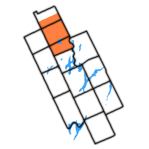
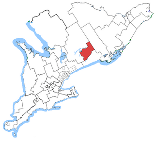
The Township of Emily was a municipality located in the south-eastern corner of the former Victoria County, now the city of Kawartha Lakes, in Ontario, Canada.
Contents
Emily Township is also home to Emily Provincial Park.
The Township of Emily was a municipality located in the south-eastern corner of the former Victoria County, now the city of Kawartha Lakes, in Ontario, Canada.
Emily Township is also home to Emily Provincial Park.

Emily Township was responsible for requesting the commissioner who eventually ordered the amalgamation of the former County of Victoria municipalities. [1]

The County of Victoria, or Victoria County, was a county in the Canadian province of Ontario. It was formed in 1854 as The United Counties of Peterborough and Victoria, and separated from Peterborough in 1863. In 2001, the county was dissolved and reformed as the city of Kawartha Lakes. Though first opened to settlement in 1821, the area that was encompassed by Victoria County has a history of Indian occupation, first by the Hurons.

The City of Kawartha Lakes is a unitary municipality in Central Ontario, Canada. It is a municipality legally structured as a single-tier city; however, Kawartha Lakes is the size of a typical Ontario county and is mostly rural. It is the second largest single-tier municipality in Ontario by land area.

Bethany is an unincorporated village in the Canadian province of Ontario, within the single-tier municipality of Kawartha Lakes. Bethany is centred on Highway 7A. It is located a few kilometers west of Peterborough, the largest city in the area.

Haliburton—Kawartha Lakes—Brock is a federal electoral district in central Ontario, Canada, that has been represented in the House of Commons of Canada since 1968.
Norland is a small rural community located within the city of Kawartha Lakes, in the Canadian province of Ontario. It is located in a scenic spot on the Gull River at the north end of Shadow Lake, the northernmost Kawartha lake in the Trent River chain. Here, a series of three waterfalls reflect the change in elevation of the land leading north to the Haliburton Highlands.
Durham County is a historic county in Ontario, Canada. It was named for the English County Durham and city of Durham. The County was created in 1792 although was later merged Northumberland County to form the United Counties of Northumberland and Durham. In 1974, the two counties were split and reorganized, with the former portions of Durham County reorganized into the Regional Municipality of Durham.

Kinmount is a village with a population of approximately 500, located on the Burnt River in Ontario, Canada. The village is apportioned by three municipalities, they are, City of Kawartha Lakes, Minden Hills and Trent Lakes. The village's hinterland covers large sections of both Haliburton and Peterborough counties for which it is a shopping and cultural centre. Prior to the formation of the City of Kawartha Lakes, Kinmount was the seat of Somerville Township.
The united Townships of Laxton, Digby and Longford were a municipality in the northern part of what is now Kawartha Lakes in the Canadian province of Ontario. In 1993, Canada's centre of population fell in the area, despite the lack of any population centers with over 1000 residents.

The Township of Bexley was a municipality located in the northern half of the former Victoria County, now the city of Kawartha Lakes, in the Canadian province of Ontario.

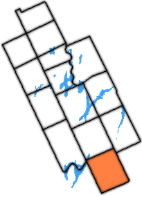
The Township of Somerville was a municipality located in the north-eastern corner of the former Victoria County, now the city of Kawartha Lakes.

The Township of Mariposa was a municipality located in the southwest corner of the former Victoria County, now the city of Kawartha Lakes, in the Canadian province of Ontario. The other municipal neighbours of Mariposa are Ops and Fenelon on the east, Eldon on the north, Brock on the west, and Scugog on the south, with the latter two located in the Durham Regional Municipality. The former township includes the communities of Little Britain, Manilla, Mariposa, Valentia, and Oakwood. Today, most of the former township is represented in the City of Kawartha Lakes by the Ward 8 Councillor, John Pollard, and Ward 4 Councillor Andrew Veale.

The Township of Ops was a municipality located in the centre of the former Victoria County, now the city of Kawartha Lakes. The township contained the communities of Reaboro and Fleetwood, and also surrounded the largest population centre in the county, Lindsay.
The Township of Manvers was a municipality in the former Victoria County, now the city of Kawartha Lakes, in the Canadian province of Ontario.
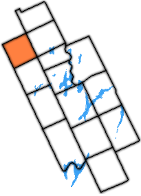
The Township of Carden was a municipality in the north-west corner of Victoria County, now the city of Kawartha Lakes, in the Canadian province of Ontario.
The Township of Dalton was a municipality located in the northwest corner of the former Victoria County, now a geographic township in the city of Kawartha Lakes, in the Canadian province of Ontario. It was named after Dr. John Dalton (1766–1844), an English scientist who contributed to the foundations of atomic theory.

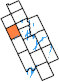
The Township of Eldon was a municipality located in the west of the former Victoria County, now the city of Kawartha Lakes, in Ontario, Canada.

The Township of Verulam was a rural municipality within the former Victoria County, now the city of Kawartha Lakes. It was bounded on the north by the geographic township of Somerville, the south by the geographic township of Emily, the west by the geographic township of Fenelon, and the east by the County of Peterborough. For the purposes of government, land suryeying and reference, it is now properly referred to as the "Geographic Township of Verulam".
Haliburton—Kawartha Lakes—Brock is a provincial electoral district in Central Ontario, Canada. It elects one member to the Legislative Assembly of Ontario.
Peterborough—Kawartha is a provincial electoral district in Ontario, Canada, that has been represented in the Legislative Assembly of Ontario since 1934.
Coordinates: 44°21′N78°33′W / 44.350°N 78.550°W
City of Kawartha Lakes | |||||||
|---|---|---|---|---|---|---|---|
| Towns |  | ||||||
| Villages and unincorporated communities |
| ||||||
| Former townships | |||||||
| Major lakes |
| ||||||
| Topics | |||||||
1) This area lies on the border of an adjacent region, but is part of the Kawartha Lakes census. | |||||||