Valentia is a small community founded in 1807, located in the city of Kawartha Lakes, just south of the town of Lindsay on County Road 18 [1] northeast of Lake Scugog. During its bicentennial celebrations in August 2007, it held its first Valentia Heritage Rodeo. [2]
In 2014, the Valentia Church celebrated its 125 anniversary as part of the Valentia Heritage Weekend. It was first constructed as a Methodist church but then became a United church.

Bethany is an unincorporated village in the Canadian province of Ontario, within the single-tier municipality of Kawartha Lakes. Bethany is centred on Highway 7A. It is located a few kilometers west of Peterborough, the largest city in the area.

Haliburton—Kawartha Lakes—Brock is a federal electoral district in central Ontario, Canada, that has been represented in the House of Commons of Canada since 1968.
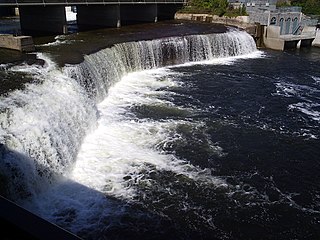
Norland is a small rural community located within the city of Kawartha Lakes, in the Canadian province of Ontario. It is located in a scenic spot on the Gull River at the north end of Shadow Lake, the northernmost Kawartha lake in the Trent River chain. Here, a series of three waterfalls reflect the change in elevation of the land leading north to the Haliburton Highlands.
The Kawartha Lakes (/kə'wɔrθɐ/) are a chain of lakes in south-central Ontario, Canada that form the upper watershed of the Trent River. The lakes are located on the boundary between the Paleozoic limestone regions of the Golden Horseshoe, and the Precambrian granite Canadian Shield of northern and central Ontario.
Glenarm is a community in the City of Kawartha Lakes of about 80 people. Very few people live in the actual hamlet itself, but the community spreads about 2 km in each direction.

Kinmount is a village with a population of approximately 500, located on the Burnt River in Ontario, Canada. The village is apportioned by three municipalities, they are, City of Kawartha Lakes, Minden Hills and Trent Lakes. The village's hinterland covers large sections of both Haliburton and Peterborough counties for which it is a shopping and cultural centre. Prior to the formation of the City of Kawartha Lakes, Kinmount was the seat of Somerville Township.

Omemee is a community within the city of Kawartha Lakes, Ontario, Canada, formerly known as Victoria County. Located on Ontario Highway 7, which is the Trans-Canada Highway, Omemee is one of the major communities in the Kawartha Lakes, as the proclaimed "city" is vastly rural and has but one major population centre. The community had a population of 1,247 in the Canada 2011 Census. It is located between the city of Peterborough and the community of Lindsay. Lindsay is the largest population centre in the city of Kawartha Lakes, and serves as the administrative centre as it did with Victoria County.
The united Townships of Laxton, Digby and Longford were a municipality in the northern part of what is now Kawartha Lakes in the Canadian province of Ontario.

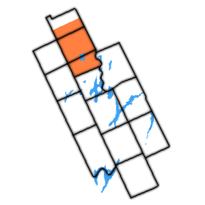
The Township of Mariposa was a municipality located in the southwest corner of the former Victoria County, now the city of Kawartha Lakes, in the Canadian province of Ontario. The other municipal neighbours of Mariposa are Ops and Fenelon on the east, Eldon on the north, Brock on the west, and Scugog on the south, with the latter two located in the Durham Regional Municipality. The former township includes the communities of Little Britain, Manilla, Mariposa, Valentia, and Oakwood. Today, most of the former township is represented in the City of Kawartha Lakes by the Ward 8 Councillor, John Pollard, and Ward 4 Councillor Andrew Veale.

The Township of Ops was a municipality located in the centre of the former Victoria County, now the city of Kawartha Lakes. The township contained the communities of Reaboro and Fleetwood, and also surrounded the largest population centre in the county, Lindsay.

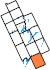
The Township of Emily was a municipality located in the south-eastern corner of the former Victoria County, now the city of Kawartha Lakes, in Ontario, Canada.
The Township of Manvers was a municipality in the former Victoria County, now the city of Kawartha Lakes, in the Canadian province of Ontario.

The Township of Verulam was a rural municipality within the former Victoria County, now the city of Kawartha Lakes. It was bounded on the north by the geographic township of Somerville, the south by the geographic township of Emily, the west by the geographic township of Fenelon, and the east by the County of Peterborough. For the purposes of government, land surveying and reference, it is now properly referred to as the "Geographic Township of Verulam".
Verulam Park is a residential community in the city of Kawartha Lakes, Ontario located at the end of Concession IV on the north shore of Sturgeon Lake. It was given for the enjoyment of the people of the Verulam Township by Colonel McAlpine, who lived in a large mansion nearby. The site also has a boat launch and wharf provided by the Canada Department of Fisheries.

Kawartha Speedway is a 3/8 mile paved oval located in Fraserville, Ontario, approximately 10 km southwest of Peterborough. The paved track is within the harness racing track, temporary grandstands are brought onto the harness racing tracks surface. In 2006, Kawartha Speedway held the final CASCAR Super Series race before it became the NASCAR Canadian Tire Series in 2007. Since 2004, Kawartha was the host of the CASCAR Super Series finale. Kawartha Speedway held the finale of the inaugural NASCAR Canadian Tire Series Season which was won by Scott Steckly. The following year, Jason Hathaway picked up his first ever win, and in 2009 D.J. Kennington won.
Haliburton—Kawartha Lakes—Brock is a provincial electoral district in Central Ontario, Canada. It elects one member to the Legislative Assembly of Ontario.
The Fénelon River is a 2 km (1.2 mi) long river that runs through the community of Fenelon Falls, City of Kawartha Lakes in the Kawartha Lakes district of Ontario, Canada. It connects Cameron Lake to Sturgeon Lake.
Dongola is an unincorporated community in the Canadian province of Ontario, located within the single-tier municipality of Kawartha Lakes at the intersection of Kawartha Lakes Road 45 and Road 42. The former post-office village contains several households and no businesses. Today, Dongola is all but a ghost town. The site resembles any nearby rural area, surrounded by farmland and forests, with no signs of a centralized built-up area.
View Lake is a small village located in Ontario, Canada. It is situated on the boundary of the Regional Municipality of Durham and the city of Kawartha Lakes, on the southern shores of Lake Scugog. The village was unincorporated in Victoria County prior to the formation of the city of Kawartha Lakes in 2001, and continues to have a very small population. It contains two small parks, and in the past, contained a train stop near its general store.
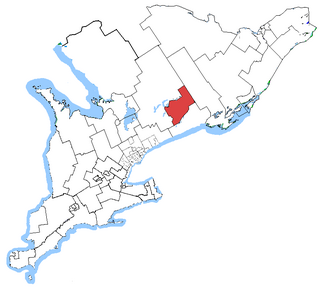
Peterborough—Kawartha is a provincial electoral district in Ontario, Canada, that has been represented in the Legislative Assembly of Ontario since 1934.
Coordinates: 44°14′47″N78°48′11″W / 44.2464°N 78.8031°W
City of Kawartha Lakes | |||||||
|---|---|---|---|---|---|---|---|
| Towns |  | ||||||
| Villages and unincorporated communities |
| ||||||
| Former townships | |||||||
| Major lakes |
| ||||||
| Topics | |||||||
1) This area lies on the border of an adjacent region, but is part of the Kawartha Lakes census. | |||||||
| | This Ontario location article is a stub. You can help Wikipedia by expanding it. |