
The Bitterroot River is a northward flowing 84-mile (135 km) river running through the Bitterroot Valley, from the confluence of its West and East forks near Conner in southern Ravalli County to its confluence with the Clark Fork River near Missoula in Missoula County, in western Montana. The Clark Fork River is tributary to the Columbia River and ultimately, the Pacific Ocean. The Bitterroot River is a Blue Ribbon trout fishery with a healthy population of native westslope cutthroat trout and bull trout. It is the third most fly fished river in Montana behind the Madison and Big Horn Rivers.
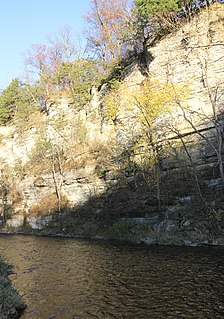
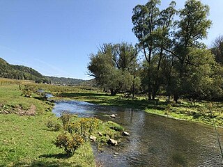
The Root River flows for 80 miles (130 km) through the Driftless Area of southeastern Minnesota and is a tributary of the Upper Mississippi River. The Root River is formed by three branches, the North, South and Middle branches of the Root River and the South Fork Root River. It is an excellent river for canoeing and fishing. The gentle to moderate flowing river drops an average of 3.4 ft/mile from Chatfield, Minnesota, to its pour point in the Mississippi River into Navigation Pool 7 just south of La Crosse, Wisconsin and east of Hokah, Minnesota.

Sonoita Creek is a tributary stream of the Santa Cruz River in Santa Cruz County, Arizona. It originates near and takes its name from the abandoned Pima mission in the high valley near Sonoita. It flows steadily for the first 15 miles (24 km) of its westward course past Patagonia, its bird sanctuary and Patagonia Lake, but sinks beneath the sand seven to eight miles before joining the Santa Cruz River a few miles north of Nogales. This confluence provides water for Tumacácori and Tubac and collects in the marsh lands around San Xavier del Bac downstream, to the north. The Santa Rita Mountains lie to the north and the Canelo Hills, Red Mountain and the Patagonia Mountains lie to the south. Harshaw Creek is a southern tributary which joins the Sonoita near Patagonia. Harshaw Creek drains the area between the Patagonia Mountains to the west and the high San Rafael Valley grasslands to the east. The ghost town of Harshaw lies within its watershed.

Mill Creek is a 14.0-mile-long (22.5 km) tributary stream of the South Branch Potomac River, belonging to the Potomac River and Chesapeake Bay watersheds. The stream is located in Hampshire County in West Virginia's Eastern Panhandle. Mill Creek flows into the South Branch west of Romney Bridge near Vanderlip along the Northwestern Turnpike.

Slate Run is a 7.3-mile-long (11.7 km) tributary of Pine Creek in Tioga and Lycoming counties, Pennsylvania in the United States.

The Potlatch River is in the state of Idaho in the United States. About 56 miles (90 km) long, it is the lowermost major tributary to the Clearwater River, a tributary of the Snake River that is in turn a tributary of the Columbia River. Once surrounded by arid grasslands of the Columbia Plateau adjacent to the western foothills of the Rocky Mountains, the Potlatch today is used mainly for agriculture and irrigation purposes.

Chatfield is a city in Fillmore and Olmsted counties in the U.S. state of Minnesota. The population was 2,779 at the 2010 census. The city's area is split almost equally between the two counties. Chatfield is known as "The Gateway to Bluff Country" and "The Chosen Valley".
Red Clover Creek is a west-northwestward-flowing stream originating on Horton Ridge east of the Sierra Nevada crest in Plumas County, California, United States. It courses 27 miles (43 km) through Dotta Canyon and Red Clover Valley to its confluence with Last Chance Creek in Genesee Valley, just above its confluence with Indian Creek, which flows into the East Branch North Fork Feather River. The Red Clover Valley sits at an elevation of about 5,400 feet (1,600 m) and is located on the east side of the Sierra Nevada crest, approximately 60 miles (97 km) north of Truckee and 30 miles (48 km) east of Quincy.

Money Creek is a stream in Houston and Winona counties, in the U.S. state of Minnesota. It is a tributary of the Root River.
Beaver Creek is a stream in Mower and Fillmore counties, in the U.S. state of Minnesota. It is a tributary of the Upper Iowa River.
Rush Creek is a stream in Fillmore and Winona counties, in the U.S. state of Minnesota. It is a tributary of the Root River, which it joins in Rushford, Minnesota.
Belle Creek is a trout stream in Goodhue County, in the U.S. state of Minnesota. It is a tributary of the Cannon River.
Lewis Creek is a tributary of the Susquehanna River in Luzerne County, Pennsylvania, in the United States. It is approximately 1.8 miles (2.9 km) long and flows through Exeter Township. The watershed of the creek has an area of 1.64 square miles (4.2 km2). The creek is not designated as impaired and has typical water chemistry for a stream of its geology and land use. Rock formations in its watershed include the Catskill Formation.
Crooked Creek is a stream in Houston County, in the U.S. state of Minnesota. Crooked Creek was so named on account of its irregular course.
Badger Creek is a stream in Houston County, in the U.S. state of Minnesota. It is a tributary of the South Fork Root River, which it meets east of Houston, Minnesota. Badger Creek was named for the badgers once common in the area.

Hunter Creek is a stream in Douglas County, Missouri. It is a tributary of Bryant Creek. Hunter Creek headwaters arise north of Ava along the south of a ridge and Missouri Route 76. The stream flows southeast along State Route FF and is further fed by Turkey Creek from the north, Wildcat Creek from the southwest and the springwaters of the rainbow trout hatchery at Crystal Springs. The stream flows on to the east gaining the tributaries of Whites Creek and Dicky Creek before joining Bryant Creek at Vera Cruz. The community of Larissa was located along Hunter Creek near Crystal Springs.
Wolf Run is a tributary of North Branch Mehoopany Creek in Bradford County and Sullivan County, in Pennsylvania, in the United States. It is approximately 3.2 miles (5.1 km) long and flows through Wilmot Township in Bradford County and Colley Township in Sullivan County. The stream's watershed has an area of 3.45 square miles (8.9 km2), most of which is agricultural land and woodlots. In a 2001 study, seven species of fish were found in Wolf Run, but no gamefish. More recently, wild trout have been observed as well.
Miller Brook is a tributary of North Branch Mehoopany Creek in Wyoming County, Pennsylvania, in the United States. It is approximately 2.2 miles (3.5 km) long and flows through North Branch Township. The watershed of the stream has an area of 3.86 square miles (10.0 km2). The stream is not designated as an impaired waterbody. Wild trout naturally reproduce in the stream, and several other fish species have been observed.

The White River is a 8-mile-long (13 km) southeastward flowing river in Wasatch and Utah Counties in eastern Utah. The White River is tributary to the Price River, which is in turn tributary to the Green River, and then to the Colorado River.
Pine Creek is a stream in Fillmore and Winona counties, in the U.S. state of Minnesota. It is a tributary of the Rush Creek, which is a tributary of the Root River. It joins the Rush Creek in the extreme north of Rushford, Minnesota. Tributaries of Pine Creek are Cooledge Creek and Hemmingway Creek.

