Camp Rapid

Last updated
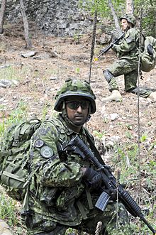
Danish Home Guard a combat patrol training exercise at West Camp Rapid during the Golden Coyote training exercise June 12, 2012. Danish Home Guard participates in Golden Coyote exercise for first time 120612-A-FY577-152.jpg
Danish Home Guard a combat patrol training exercise at West Camp Rapid during the Golden Coyote training exercise June 12, 2012.

Camp Rapid is a South Dakota Army National Guard installation located in Westside, Rapid City, South Dakota just inside the edge of the Black Hills. Although the South Dakota state capital is Pierre, South Dakota, the state's Adjutant General has his office and headquarters in Camp Rapid.

Contents

Background

Camp Rapid developed as a summer encampment site for the South Dakota National Guard in the early 20th century, using land borrowed from the Bureau of Indian Affairs "Sioux Sanitorium" and Rapid City Indian School, today's Indian Health Service (IHS) SiouxSan Hospital, located just west of Camp Rapid. It became a permanent installation during and immediately after World War I, when it was used for mobilization of National Guard units for the front in France. Its use continued during the 1920s and 1930s, and it was taken over as a federal installation during World War II. Permanent and temporary buildings erected during World War II continue in use today.

During the Cold War, Camp Rapid continued to host and support National Guard activities, including a series of annual exercises involving National Guard troops from many states conducting operations in the Black Hills. In the early 1990s, a new series of building projects replaced tent pads and brick and metal "tents" with permanent structures for use as armories, barracks, and support facilities. Security of the Camp was upgraded significantly in the early 2000s as part of nationwide security improvements. While small, the camp is a showcase for the National Guard and one of three active, manned military installations remaining in the Black Hills, and one of four in South Dakota. [1]

See also

Related Research Articles

South Dakota U.S. state

South Dakota is a U.S. state in the North Central region of the United States. It is also part of the Great Plains. South Dakota is named after the Lakota and Dakota Sioux Native American tribes, who comprise a large portion of the population with nine reservations currently in the state and have historically dominated the territory. South Dakota is the seventeenth largest by area, but the 5th least populous, and the 5th least densely populated of the 50 United States. As the southern part of the former Dakota Territory, South Dakota became a state on November 2, 1889, simultaneously with North Dakota. They are the 39th and 40th states admitted to the union; President Benjamin Harrison shuffled the statehood papers before signing them so that no one could tell which became a state first. Pierre is the state capital, and Sioux Falls, with a population of about 187,200, is South Dakota's largest city.

The Lakota are a Native American people. Also known as the Teton Sioux, they are one of the three prominent subcultures of the Sioux people. Their current lands are in North and South Dakota. They speak Lakȟótiyapi—the Lakota language, the westernmost of three closely related languages that belong to the Siouan language family.

Spearfish, South Dakota City in South Dakota, United States

Spearfish is a city in Lawrence County, South Dakota. The population was 12,193 at the time of the 2020 census.

Rapid City, South Dakota City in South Dakota, United States

Rapid City is the second most populous city in South Dakota and the county seat of Pennington County. Named after Rapid Creek, where the settlement developed, it is in western South Dakota, on the Black Hills' eastern slope. The population was 74,703 as of the 2020 Census.

Ellsworth Air Force Base US Air Force base in Rapid City, South Dakota, US

Ellsworth Air Force Base (AFB) is a United States Air Force base located about 10 miles (16 km) northeast of Rapid City, South Dakota, just north of the town of Box Elder.

The Dakotas Region in the United States

The Dakotas is a collective term for the U.S. states of North Dakota and South Dakota. It has been used historically to describe the Dakota Territory, and is still used for the collective heritage, culture, geography, fauna, sociology, economy, and cuisine among the two states.

Black Elk Peak Highest point in South Dakota

Black Elk Peak is the highest natural point in the U.S. state of South Dakota and the Midwestern United States. It lies in the Black Elk Wilderness area, in southern Pennington County, in the Black Hills National Forest. The peak lies 3.7 mi (6.0 km) west-southwest of Mount Rushmore. At 7,244 feet (2,208 m), it has been described by the Board on Geographical Names as the highest summit in the United States east of the Rocky Mountains. Though part of the North American Cordillera, it is generally considered to be geologically separate from the Rocky Mountains. Lost Mine peak in the Chisos Mountains of Texas, at an elevation of 7,535 feet, is the easternmost peak within the continental United States above 7,000 feet.

Sioux Falls Regional Airport Airport

Sioux Falls Regional Airport, also known as Joe Foss Field, is a public and military use airport three miles northwest of Sioux Falls, South Dakota, United States. It is named in honor of aviator and Sioux Falls native Joe Foss, who later served as the 20th Governor of South Dakota (1955–1959).

Sioux Wars Conflicts between the United States and indigenous Sioux tribes from 1854 to 1891

The Sioux Wars were a series of conflicts between the United States and various subgroups of the Sioux people which occurred in the later half of the 19th century. The earliest conflict came in 1854 when a fight broke out at Fort Laramie in Wyoming, when Sioux warriors killed 31 American soldiers in the Grattan Massacre, and the final came in 1890 during the Ghost Dance War.

Standing Rock Indian Reservation Native American reservation in the United States

The Standing Rock Reservation lies across the border between North and South Dakota in the United States, and is inhabited by ethnic "Hunkpapa and Sihasapa bands of Lakota Oyate and the Ihunktuwona and Pabaksa bands of the Dakota Oyate," as well as the Hunkpatina Dakota. The Ihanktonwana Dakota are the Upper Yanktonai, part of the collective of Wiciyena. The sixth-largest Native American reservation in land area in the US, Standing Rock includes all of Sioux County, North Dakota, and all of Corson County, South Dakota, plus slivers of northern Dewey and Ziebach counties in South Dakota, along their northern county lines at Highway 20.

Battle of Whitestone Hill Battle of the American Civil War

The Battle of Whitestone Hill was the culmination of the 1863 operations against the Sioux or Dakota people in Dakota Territory. Brigadier General Alfred Sully attacked a village September 3–5, 1863. The Native Americans in the village included Yanktonai, Santee, and Teton (Lakota) Sioux. Sully killed, wounded, or captured 300 to 400 Sioux, including women and children, at a cost of about 60 casualties. Sully would continue the conflict with another campaign in 1864.

West River (South Dakota) Region of South Dakota, United States

West River is the portion of the state of South Dakota located west of the Missouri River with over one-half of the land area and between one-quarter and one-third of the population of the state.

The Black Hills Gold Rush took place in Dakota Territory in the United States. It began in 1874 following the Custer Expedition and reached a peak in 1876–77.

South Dakota Air National Guard Military unit

The South Dakota Air National Guard is the aerial militia of the State of South Dakota, United States of America. It is, along with the South Dakota Army National Guard, an element of the South Dakota National Guard.

Black Hills Mountain range in South Dakota and Wyoming

The Black Hills are a small and isolated mountain range rising from the Great Plains of North America in western South Dakota and extending into Wyoming, United States. Black Elk Peak, which rises to 7,244 feet (2,208 m), is the range's highest summit. The Black Hills encompass the Black Hills National Forest. The name of the hills in Lakota is Pahá Sápa, meaning “the heart of everything that is." The Black Hills are considered a holy site. The hills are so called because of their dark appearance from a distance, as they are covered in evergreen trees.

Great Sioux War of 1876 Battles and negotiations between the US and the Lakota Sioux and Northern Cheyenne

The Great Sioux War of 1876, also known as the Black Hills War, was a series of battles and negotiations that occurred in 1876 and 1877 in an alliance of Lakota Sioux and Northern Cheyenne against the United States. The cause of the war was the desire of the US government to obtain ownership of the Black Hills. Gold had been discovered in the Black Hills, settlers began to encroach onto Native American lands, and the Sioux and the Cheyenne refused to cede ownership. Traditionally, American military and historians place the Lakota at the center of the story, especially because of their numbers, but some Native Americans believe the Cheyenne were the primary target of the American campaign.

Black Hills land claim Land dispute between Native Americans and the US government

The Black Hills land claim is an ongoing land dispute between Native Americans from the Sioux Nation and the United States government over the Black Hills mountain range in the US states of South Dakota and Wyoming. The land in question was pledged to the Sioux Nation in the Fort Laramie Treaty of April 29, 1868, but a few years later illegally seized and the treaty nullified in the Indian Appropriations Bill of 1876 without the tribe's consent. That bill "denied the Sioux all further appropriation and treaty-guaranteed annuities" until they gave up the Black Hills. A Supreme Court case was ruled in favor of the Sioux in 1980. The Sioux have outstanding issues with the ruling and have not collected the funds. As of 2011, the award was worth over $1 billion.

Fort Meade (South Dakota) Military base in South Dakota, United States

Fort Meade is a former United States Army post located just east of Sturgis, South Dakota. The fort was active from 1878 to 1944; the cantonment is currently home to a Veterans Health Administration hospital and South Dakota Army National Guard training facilities. Much of the former reservation is now managed by the Bureau of Land Management as the Fort Meade Recreation Area. It is also home of Fort Meade National Cemetery. Fort Meade was established in 1878 to protect illegal white settlements on the Great Sioux Reservation in the northern Black Hills, especially the nearby gold mining area around Deadwood. Several stage and freighting routes passed through Fort Meade en route to Deadwood.

This timeline of South Dakota is a list of events in the history of South Dakota by year.

References

  1. "South Dakota National Guard Joint Force Headquarters". Archived from the original on 2014-02-02. Retrieved 2014-02-09.

Coordinates: 44°04′45″N103°16′01″W / 44.07917°N 103.26694°W / 44.07917; -103.26694