
The geography of Switzerland encompasses the geographical features of Switzerland, a mountainous and landlocked country located in Western and Central Europe. It is surrounded by 5 countries: Austria and Liechtenstein to the east, France to the west, Italy to the south and Germany to the north. Switzerland has a maximum north–south length of 220 kilometres (140 mi) and an east–west length of about 350 kilometres (220 mi).

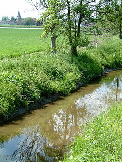
A valley is a low area between hills or mountains typically with a river running through it. In geology, a valley or dale is a depression that is longer than it is wide. The terms U-shaped and V-shaped are descriptive terms of geography to characterize the form of valleys. Most valleys belong to one of these two main types or a mixture of them, at least with respect to the cross section of the slopes or hillsides.

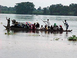
Bangladesh is a densely-populated, low-lying, mainly riverine country located in South Asia with a coastline of 580 km (360 mi) on the northern littoral of the Bay of Bengal. The delta plain of the Ganges (Padma), Brahmaputra (Jamuna), and Meghna Rivers and their tributaries occupy 79 percent of the country. Four uplifted blocks occupy 9 percent, and steep hill ranges up to approximately 1,000 metres (3,300 ft) high occupy 12 percent in the southeast and in the northeast. Straddling the Tropic of Cancer, Bangladesh has a tropical monsoon climate characterised by heavy seasonal rainfall, high temperatures, and high humidity. Natural disasters such as floods and cyclones accompanied by storm surges periodically affect the country. Most of the country is intensively farmed, with rice the main crop, grown in three seasons. Rapid urbanisation is taking place with associated industrial and commercial development. Exports of garments and shrimp plus remittances from Bangladeshis working abroad provide the country's three main sources of foreign exchange income.

A waterfall is an area where water flows over a vertical drop or a series of steep drops in the course of a stream or river. Waterfalls also occur where meltwater drops over the edge of a tabular iceberg or ice shelf.

The river Ticino is the most important perennial left-bank tributary of the Po. It has given its name to the Swiss canton through which its upper portion flows.

The Kuban River is a river in the Northwest Caucasus region of European Russia. It flows mostly through Krasnodar Krai for 660 kilometres (410 mi) but also in the Karachay–Cherkess Republic, Stavropol Krai and the Republic of Adygea.
The Kwilu River is a major river that originates in Angola and flows north through Bandundu Province in the Democratic Republic of the Congo (DRC) to the city of Bandundu, where it joins the Kwango River just before this stream enters the Kasai River. In the DRC the river flows past the towns of Gungu, Kikwit, Bulungu, Bagata, Rutherfordia and Bandundu. Lusanga, formerly Leverville, lies at the location where the Kwenge River joins the Kwilu, between Kikwit and Bulungu.

Nizhnyaya Tunguska is a river in Siberia, Russia, that flows through the Irkutsk Oblast and the Krasnoyarsk Krai. The river is a right tributary of the Yenisei joining it at Turukhansk. Settlements on the river include Tura, Yukti and Simenga. The ice-free period on the Lower Tunguska starts in mid-June and ends in the first half of October. The river forms the western limit of the Lena Plateau.

The Metauro is a river in the Marche region of central Italy. It rises in the Apennine Mountains and runs east for 110 kilometres (68 mi) or 121 kilometres (75 mi) if the Meta is included as its uppermost reach.

The Arda is a torrent of Emilia-Romagna, Italy, nearly all of its course being within the province of Piacenza. It is a right tributary of the Po River.

The Lachung River is a tributary of the Teesta River located in the East Indian state of Sikkim. It is a chief tributary of the Teesta, which is an important river in Sikkim along with Rangeet River. The village of Lachung is perched on the craggy bank of the river approximately 23 kilometres (14 mi) from Chungthang. It is at Chungthang where the Lachung and Lachen rivers converge and give rise to the Teesta. The river is 2,500 metres (8,200 ft) above sea level.

Cannobio is a town and comune on the river Cannobino and the shore of Lago Maggiore in Piedmont, Italy.

Rocca San Felice is a town and comune in the province of Avellino, Campania, southern Italy.

The Toce is a river in Piedmont, Italy, which stretches the length of the Val d'Ossola from the Swiss border to Lake Maggiore into which it debouches near Fondotoce in the commune of Verbania. The river is 83.6 kilometres (51.9 mi) long and is formed in the upper Val Formazza by the confluence of a number of torrents in the plain of Riale.

The Ripoll is a river in the comarca of Vallès Occidental, Catalonia, Spain. It covers the vast majority of the shire, crossing it from north to south, and flows into the river Besòs, near Barcelona.

The river Tresa leaves Lake Lugano at a point between Lavena Ponte Tresa in Italy and Ponte Tresa in Switzerland and flows into Lake Maggiore near Luino, a few hundred metres after joining the Margorabbia. At the outflow from Lake Lugano the river is crossed by a bridge which unites the Swiss and Italian parts of Ponte Tresa; a customs post divides them.

The Varaita is a 75-kilometre (47 mi) river of the Province of Cuneo in northwest Italy. It is the first right tributary of the Po River.
The Adyar or Adayar, originating near the Chembarambakkam Lake in Kanchipuram district, is one of the three rivers which winds through Chennai (Madras), Tamil Nadu, India, and joins the Bay of Bengal at the Adyar estuary. The 42.5-kilometre (26.4 mi) long river contributes to the estuarine ecosystem of Chennai. Despite the high pollution levels, boating and fishing take place in this river. The river collects surplus water from about 200 tanks and lakes, small streams and the rainwater drains in the city, with a combined catchment area of 860 square kilometres (331 sq mi). Most of the waste from the city is drained into this river and the Cooum.
The Eckbach is a small river in the northeastern Palatinate and the southeastern Rhenish Hesse. It is slightly over 39 kilometres (24 mi) long.

The Pentecôte River is a river in the Côte-Nord region or the province of Quebec, Canada. It is a tributary of the Gulf of Saint Lawrence, which it enters beside the community of Rivière-Pentecôte.


