Canton Lake is a lake in Blaine and Dewey Counties in Oklahoma, near Longdale and Canton. Its main source of water is the North Canadian River. It is about an hour away from Enid. The lake serves as a municipal water supply reservoir for Oklahoma City, which pays to have water released from the lake for water-supply purposes.
Konawa Reservoir is a reservoir located in Seminole County, Oklahoma. The lake covers approximately 1,350 acres (5.5 km2) and has a capacity of 23,000 acre-feet (28,000,000 m3). It is owned by Oklahoma Gas and Electric (OG&E) Company. and was constructed in 1968-70, to provide cooling for a nearby gas-fired electric power generation plant. It impounds Jumper Creek, about 2 miles (3.2 km) east of the city of Konawa, Oklahoma.

Lake Havasu is a large reservoir formed by Parker Dam on the Colorado River, on the border between San Bernardino County, California and Mohave County, Arizona. Lake Havasu City sits on the Arizonan side of the lake with its Californian counterpart of Havasu Lake directly across the lake. The reservoir has an available capacity of 619,400 acre-feet (764,000,000 m3). The concrete arch dam was built by the United States Bureau of Reclamation between 1934 and 1938. The lake's primary purpose is to store water for pumping into two aqueducts. Prior to the dam construction, the area was home to the Mojave people. The lake was named after the Mojave word for blue. In the early 19th century, it was frequented by beaver trappers. Spaniards also began to mine the areas along the river.

Lake Murray is a reservoir in San Diego, California, operated by the City of San Diego's Public Utilities Department. Although thinly divided by a few housing communities and select roadways, it is technically considered to be part of the jurisdiction which makes up Mission Trails Regional Park. When full, the reservoir covers 171.1 acres (69.2 ha), has a maximum water depth of 95 feet (29 m), and a shoreline of 3.2 miles (5.1 km). The asphalt-paved service road lining roughly two-thirds of the lake's perimeter is a popular recreation site for the Navajo community as well as residents of the northernmost neighborhoods in La Mesa. It lies south of Cowles Mountain and a small golf course. It also functions as an important aeronautical reporting point for aircraft inbound to land at Montgomery-Gibbs Executive Airport.

Lake of Egypt is a reservoir in the Little Egypt region of the U.S. state of Illinois. It is located six miles (10 km) south of Marion, Illinois and covers 2,300 acres (9 km²) with 90 miles (140 km) of shoreline. The lake has an average depth of 18 feet (5.5 m) with a maximum depth of 52 feet (16 m). The lake is owned by the Southern Illinois Power Cooperative (SIPC), who created the impoundment in 1962, by damming the South fork of the Saline River, to supply cooling water for a coal-burning electric power plant.

Clinton Lake is a 4,900 acres (19.8 km2) reservoir located near Clinton, Illinois. The lake is a part of the Clinton Lake State Recreation Area, which encompasses 9,300 acres (37.6 km2). It was built in the 1970s as a cooling source for the Clinton Nuclear Generating Station. The lake opened in 1978.

Folsom Lake is a reservoir on the American River in the Sierra Nevada foothills of California, United States.
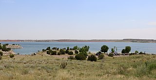
Averhoff Reservoir is a 173-acre narrow, riverine-type reservoir located on the Nueces River 10 mi (16 km) north of the town of Crystal City in Zavala County, Texas, United States, and 100 miles from San Antonio, Texas.
Show Low Lake is a 100-acre (0.40 km2) lake nestled at 6,500 feet (2,000 m) elevation in the White Mountains of Arizona which is administered by the Arizona Game and Fish Department along with the city of Show Low. Show Low Lake Park is located five miles (8 km) south of Show Low.

Spruce Run Recreation Area is a 1,290-acre (5.2 km2) New Jersey state recreation area located in Union Township and Clinton Township in Hunterdon County, New Jersey, United States. It encompasses the Spruce Run Reservoir that is used as a backup reservoir to protect the state from prolonged droughts. The reservoir is the third largest in the state, after Round Valley and Wanaque Reservoir. The reservoir is used for recreation purposes, including hunting, fishing, boating and swimming.
Comanche Creek Reservoir is a 3,275-acre (13.3 km²) impoundment located between Glen Rose, Texas and Granbury, Texas. The primary purpose is cooling for Comanche Peak Nuclear Generating Station. During full operation of both units of Comanche Peak, 2.2 million US gallons (8,300 m3) of water are pumped through the plant's main condensers from Comanche Creek Reservoir.

Silver Springs State Fish and Wildlife Area is an Illinois state park on 1,350 acres (550 ha) in Kendall County, Illinois, United States. The park was established in the late 1960s and is named for the natural spring within its boundaries. The park has two artificial lakes and the Fox River flows through the northern end of the park. Silver Springs hosts a variety of activities including fishing, hunting, boating and hiking. The park has areas of native prairie restoration, a sledding hill and a seven-mile (11 km) equestrian trail. The prairie restoration areas hold many species of plants including lead plant, and purple coneflower.
Built in 1928, Scott Reservoir is an irrigation impoundment on Porter Creek near Pinetop-Lakeside, Arizona, USA. The least developed of the "in town" lakes, trees surround Scott Reservoir. It lies just outside the town limits on the Apache-Sitgreaves National Forests.
Lake Wedowee, or R. L. Harris Reservoir, is a reservoir, located in Randolph County, Alabama on the upper part of the Tallapoosa River 90 miles (140 km) from Atlanta, Georgia. The lake has an area of 9,870 acres (39.9 km2). This lake was built at one of the last hydro sites in Alabama.
Lake Pueblo State Park is a state park located in Pueblo County, Colorado. It includes 60 miles (97 km) of shoreline and 10,000 acres (40 km2) of land. Activities it offers include two full-service marinas, recreational fishing, hiking, camping and swimming at a special swim beach.

Boomer Lake is located in the city of Stillwater, Oklahoma, United States, and was completed in 1925. The lake, as an artificial reservoir created by damming Boomer Creek, serves several purposes such as cooling the local power plant and providing entertainment and recreation. Boomer Lake has a surface area of 251 acres (1,020,000 m2), watershed area of 8,954 acres (36,240,000 m2), shoreline length of 8.6 miles (13.8 km), shoreline development ratio of 4.17, and mean depth of 9.7 feet (3.0 m). The lake was designed to contain 3,600 acre-feet (4,400,000 m3) in 1932, but in 2010 the capacity was reportedly only 1,484 acre-feet (1,830,000 m3).

Lake Alan Henry is a reservoir situated in the upper Brazos River Basin in the United States. Created by the construction of the John T. Montford Dam in 1993, it is operated and used as a future tertiary water supply by the city of Lubbock, Texas and serves as a recreational spot for the region of West Texas. The surface area of the lake is 2,880 acres (1,170 ha) with a mean depth of 40 ft (12 m). Lake Alan Henry is located 4 mi (6.4 km) east of Justiceburg, Texas, and 45 mi (72 km) south of Lubbock.

Powerton Lake State Fish and Wildlife Area is a 1,426-acre (577 ha) area of semi-protected habitat on the Illinois River southwest of to the city of Pekin, Illinois within Tazewell County in the U.S. state of Illinois. The parcel is a cooling reservoir owned by NRG Energy, an electric power generating firm, and is operated by the Illinois Department of Natural Resources (IDNR). The lake is used for fishing, with an emphasis on blue catfish. In addition, IDNR states that approximately 60% of the cooling pond is used for duck and goose hunting during legal hunting seasons. The remaining 40% of the pond is maintained as a waterfowl refuge on a year-round basis.
Lake Centralia is a reservoir in Marion County, Illinois. Served by rural roads, it is 8 miles east of the Illinois city of Centralia. The reservoir is 412 acres in size, has a shoreline length of 12.9 miles, and possesses an average water depth of 10 feet. The city, which owns the lake for water-supply purposes, works with the Illinois Department of Natural Resources (IDNR) to stock it with fish. The IDNR reports that lake fishing specializes in stocked bass, including largemouth bass. The lake also offers channel catfish, white and black crappies, and bluegill. The marina is located on the north side of the lake, and there are no restrictions on boat fishing.
Raccoon Lake, also called Raccoon Creek Reservoir, is a reservoir in Marion County, Illinois. Served by Illinois Route 161, it is 2 miles (3 km) northeast of the Illinois city of Centralia. The reservoir is 970 acres in size, has a shoreline length of 16.4 miles, and possesses an average water depth of 3.9 feet.


