Related Research Articles
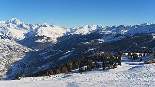
Savoie is a department in the Auvergne-Rhône-Alpes region, Southeastern France. Located in the French Alps, its prefecture is Chambéry. In 2019, Savoie had a population of 436,434.

The Arly is a 32.1 km long river in the departments of Savoie and Haute-Savoie, France. It is a tributary of the Isère, which it joins at Albertville.

Bourg-Saint-Maurice, popularly known as Bourg, is a commune in the Savoie department in the Auvergne-Rhône-Alpes region in south-eastern France. Located on the Italian border south of Chamonix-Mont-Blanc, it had a population of 7,252 as of 2018. It serves as a transport hub for the Paradiski ski area, with direct rail travel from London, and Amsterdam during the winter.

The arrondissement of Albertville is an arrondissement of France in the Savoie department in the Auvergne-Rhône-Alpes region. It has 69 communes. Its population is 111,751 (2016), and its area is 2,466.1 km2 (952.2 sq mi).
The following is a list of the 19 cantons of the Savoie department, in France, following the French canton reorganisation which came into effect in March 2015:
Maurienne is one of the provinces of Savoy, corresponding to the arrondissement of Saint-Jean-de-Maurienne in France. It is also the original name of the capital of the province, now Saint-Jean-de-Maurienne.
The Canton of Albertville-Nord is a French former administrative subdivision, situated in the Savoie département and the Rhône-Alpes région. It was created in 1973. It was disbanded following the French canton reorganisation which came into effect in March 2015. In 2012, the population was 15,530.
The Canton of Albertville-Sud is a French former administrative subdivision, situated in the Savoie département and the Rhône-Alpes région. It was created in 1973. It was disbanded following the French canton reorganisation which came into effect in March 2015. In 2012, the population was 19,641.

The A430 autoroute is a short motorway in France. At just 15 km, the road is a short spur which connects the A43 autoroute to Albertville. The A430 follows the N90 along the Isère river valley until the two merge just outside Albertville whereby the N90 continues as a dual carriageway to Moûtiers.

Gilly-sur-Isère is a commune in the Savoie department in the Auvergne-Rhône-Alpes region in south-eastern France.

La Léchère is a commune in the Savoie department in the Auvergne-Rhône-Alpes region in south-eastern France. It is situated in the Isère valley, between Albertville and Moûtiers. It was formed in 1972 by the merger of the former communes Notre-Dame-de-Briançon, Celliers, Doucy, Naves, Petit-Cœur and Pussy. On 1 January 2019, the former communes Bonneval and Feissons-sur-Isère were merged into La Léchère.
The canton of Modane is an administrative division of the Savoie department, southeastern France. Its borders were modified at the French canton reorganisation which came into effect in March 2015. Its seat is in Modane.
The canton of Moûtiers is an administrative division of the Savoie department, southeastern France. Its borders were modified at the French canton reorganisation which came into effect in March 2015. Its seat is in Moûtiers.
The canton of Saint-Jean-de-Maurienne is an administrative division of the Savoie department, southeastern France. Its borders were modified at the French canton reorganisation which came into effect in March 2015. Its seat is in Saint-Jean-de-Maurienne.
The canton of Albertville-1 is an administrative division of the Savoie department, southeastern France. It was created at the French canton reorganisation which came into effect in March 2015. Its seat is in Albertville.
The canton of Saint-Pierre-d'Albigny is an administrative division of the Savoie department, southeastern France. Its borders were modified at the French canton reorganisation which came into effect in March 2015. Its seat is in Saint-Pierre-d'Albigny.

The canton of Ugine is an administrative division of the Savoie department, southeastern France. Its borders were modified at the French canton reorganisation which came into effect in March 2015. Its seat is in Ugine.
The canton of Sallanches is an administrative division of the Haute-Savoie department, southeastern France. Its borders were modified at the French canton reorganisation which came into effect in March 2015. Its seat is in Sallanches.
The canton of Romans-sur-Isère is an administrative division of the Drôme department, southeastern France. It was created at the French canton reorganisation which came into effect in March 2015. Its seat is in Romans-sur-Isère.
Communauté d'agglomération Arlysère is the communauté d'agglomération, an intercommunal structure, centred on the town of Albertville. It is located in the Savoie department, in the Auvergne-Rhône-Alpes region, southeastern France. Created in 2017, its seat is in Albertville. The name Arlysère refers to the rivers Arly and Isère. Its area is 763.6 km2. Its population was 61,292 in 2019, of which 19,502 in Albertville proper.
References
45°40′N6°23′E / 45.67°N 6.38°E
| | This Savoie geographical article is a stub. You can help Wikipedia by expanding it. |