Related Research Articles
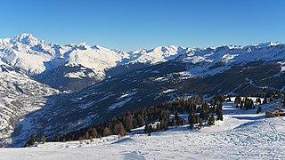
Savoie is a department in the Auvergne-Rhône-Alpes region, Southeastern France. Located in the French Alps, its prefecture is Chambéry. In 2019, Savoie had a population of 436,434.

Aix-les-Bains ,known locally and simply as Aix, is a commune in the southeastern French department of Savoie.

The arrondissement of Thonon-les-Bains is an arrondissement of France in the Haute-Savoie department in the Auvergne-Rhône-Alpes region. It has 68 communes. Its population is 145,809 (2016), and its area is 907.7 km2 (350.5 sq mi).

The arrondissement of Albertville is an arrondissement of France in the Savoie department in the Auvergne-Rhône-Alpes region. It has 69 communes. Its population is 111,751 (2016), and its area is 2,466.1 km2 (952.2 sq mi).

The arrondissement of Chambéry is an arrondissement of France in the Savoie department in the Auvergne-Rhône-Alpes region. It has 151 communes. Its population is 274,839 (2016), and its area is 1,586.1 km2 (612.4 sq mi).
The following is a list of the 19 cantons of the Savoie department, in France, following the French canton reorganisation which came into effect in March 2015:
The following is a list of the 17 cantons of the Haute-Savoie department, in France, following the French canton reorganisation which came into effect in March 2015:

Chambéry Airport or Chambéry-Savoie Airport, also known as Chambéry Aix-les-Bains Airport, is a small international airport near Chambéry, a commune in Savoy, France. Commercial activities started at the airport in 1960.

Aix-les-Bains, Savoie, France had a race track, called Circuit du Lac, which hosted Formula 2, Formula Junior, and Motorcycle Grand Prix races between 1949 and 1960.

Mouxy is a commune in the Savoie department in the Auvergne-Rhône-Alpes region in south-eastern France.
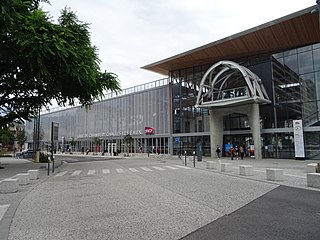
Chambéry-Challes-les-Eaux station is a railway station in the Savoie département of France. The station serves the city of Chambéry. The station is served by three major high speed services, the TGV, Eurostar and Frecciarossa.
The Albanais is a small Savoyard region situated between Lake Annecy and Lac du Bourget, at the entrance to the Parc naturel régional du Massif des Bauges. Located in the French departments of Savoie and Haute-Savoie, its principal city is Rumilly. The name Albanais comes from the Latin Albinnum, which is derived from the names of the tribes Albii whose presence is attested to in the toponymy of places such as Albens, Alby, and Albigny.
Les-bains or Les bains, usually indicating the presence of a spa, may refer to:

L'Almée is a yacht built in 1886 by the Chantiers de la Seine of Argenteuil. She is now a maritime store at Aix-les-Bains, on the Lac du Bourget.
The canton of Aix-les-Bains-1 is an administrative division of the Savoie department, southeastern France. It was created at the French canton reorganisation which came into effect in March 2015. Its seat is in Aix-les-Bains.
The canton of Moûtiers is an administrative division of the Savoie department, southeastern France. Its borders were modified at the French canton reorganisation which came into effect in March 2015. Its seat is in Moûtiers.
The canton of Annecy-3 is an administrative division of the Haute-Savoie department, southeastern France. Its borders were modified at the French canton reorganisation which came into effect in March 2015. Its seat is in Annecy.
The canton of Évian-les-Bains is an administrative division of the Haute-Savoie department, southeastern France. Its borders were modified at the French canton reorganisation which came into effect in March 2015. Its seat is in Évian-les-Bains.

The canton of Le Mont-Blanc is an administrative division of the Haute-Savoie department, Southeastern France. It elects two members of the Departmental Council of Haute-Savoie, known as departmental councillors. It was created at the 2014 cantonal reorganisation process, which came into effect for the 2015 departmental election. Its seat is Passy, its most populated commune.
The canton of Thonon-les-Bains is an administrative division of the Haute-Savoie department, southeastern France. It was created at the French canton reorganisation which came into effect in March 2015. Its seat is in Thonon-les-Bains.
References
45°41′N5°55′E / 45.69°N 5.91°E
| | This Savoie geographical article is a stub. You can help Wikipedia by expanding it. |