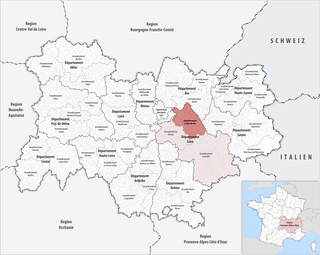
The arrondissement of La Tour-du-Pin is an arrondissement of France in the Isère department in the Auvergne-Rhône-Alpes region. Since the January 2017 reorganization of the arrondissements of Isère, it has 137 communes.
The following is a list of the 29 cantons of the Isère department, in France, following the French canton reorganisation which came into effect in March 2015:
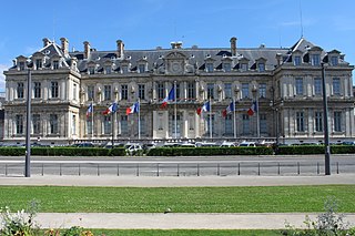
Charvieu-Chavagneux is a commune in the Isère department in southeastern France.

The Bourbre is a 72.2 km (44.9 mi) long river in the Isère and Rhône departments in central eastern France. Its source is in Burcin. It flows generally north-northwest. It is a left tributary of the Rhone, into which it flows at Chavanoz.
The canton of Romans-sur-Isère is an administrative division of the Drôme department, southeastern France. It was created at the French canton reorganisation which came into effect in March 2015. Its seat is in Romans-sur-Isère.
The canton of Bièvre is an administrative division of the Isère department, eastern France. It was created at the French canton reorganisation which came into effect in March 2015. Its seat is in La Côte-Saint-André.
The canton of Bourgoin-Jallieu is an administrative division of the Isère department, eastern France. It was created at the French canton reorganisation which came into effect in March 2015. Its seat is in Bourgoin-Jallieu.
The canton of Chartreuse-Guiers is an administrative division of the Isère department, eastern France. It was created at the French canton reorganisation which came into effect in March 2015. Its seat is in Saint-Laurent-du-Pont.
The canton of Le Grand-Lemps is an administrative division of the Isère department, eastern France. Its borders were modified at the French canton reorganisation which came into effect in March 2015. Its seat is in Le Grand-Lemps.
The canton of Morestel is an administrative division of the Isère department, eastern France. Its borders were modified at the French canton reorganisation which came into effect in March 2015. Its seat is in Morestel.
The canton of Oisans-Romanche is an administrative division of the Isère department, eastern France. It was created at the French canton reorganisation which came into effect in March 2015. Its seat is in Vizille.
The canton of Le Sud Grésivaudan is an administrative division of the Isère department, eastern France. It was created at the French canton reorganisation which came into effect in March 2015. Its seat is in Saint-Marcellin.
The canton of Voiron is an administrative division of the Isère department, eastern France. Its borders were modified at the French canton reorganisation which came into effect in March 2015. Its seat is in Voiron.
The canton of Grenoble-3 is an administrative division of the Isère department, eastern France. Its borders were modified at the French canton reorganisation which came into effect in March 2015. Its seat is in Grenoble.
The canton of L'Isle-d'Abeau is an administrative division of the Isère department, eastern France. Its borders were modified at the French canton reorganisation which came into effect in March 2015. Its seat is in L'Isle-d'Abeau.
The canton of Le Moyen Grésivaudan is an administrative division of the Isère department, eastern France. It was created at the French canton reorganisation which came into effect in March 2015. Its seat is in Crolles.
The canton of Le Pont-de-Claix is an administrative division of the Isère department, eastern France. It was created at the French canton reorganisation which came into effect in March 2015. Its seat is in Le Pont-de-Claix.
The canton of Saint-Martin-d'Hères is an administrative division of the Isère department, eastern France. It was created at the French canton reorganisation which came into effect in March 2015. Its seat is in Saint-Martin-d'Hères.
The canton of Tullins is an administrative division of the Isère department, eastern France. Its borders were modified at the French canton reorganisation which came into effect in March 2015. Its seat is in Tullins.
The canton of La Verpillière is an administrative division of the Isère department, eastern France. Its borders were modified at the French canton reorganisation which came into effect in March 2015. Its seat is in La Verpillière.