
The arrondissement of Tours is an arrondissement of France in the Indre-et-Loire department in the Centre-Val de Loire region. It has 54 communes. Its population is 384,117 (2016), and its area is 1,087.6 km2 (419.9 sq mi).

The arrondissement of Chalon-sur-Saône is an arrondissement of France in the Saône-et-Loire department in the Bourgogne-Franche-Comté region. It has 142 communes. Its population is 156,331 (2016), and its area is 1,484.5 km2 (573.2 sq mi).

The arrondissement of Charolles is an arrondissement of France in the Saône-et-Loire department in the Bourgogne-Franche-Comté region. It has 126 communes. Its population is 87,416 (2016), and its area is 2,443.8 km2 (943.6 sq mi).

The arrondissement of Louhans is an arrondissement of France in the Saône-et-Loire department in the Bourgogne-Franche-Comté region. It has 88 communes. Its population is 67,030 (2016), and its area is 1,430.2 km2 (552.2 sq mi).

The arrondissement of Laval is an arrondissement of France in the Mayenne department in the Pays de la Loire region. It has 34 communes. Its population is 112,937 (2016), and its area is 686.1 km2 (264.9 sq mi).
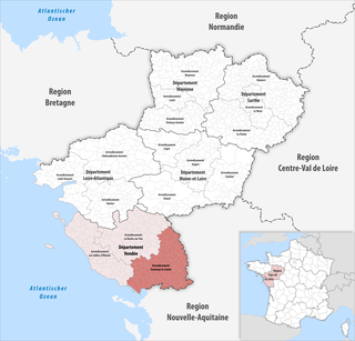
The arrondissement of Fontenay-le-Comte is an arrondissement of France in the Vendée department in the Pays de la Loire region. It has 105 communes. Its population is 141,620 (2016), and its area is 2,315.8 km2 (894.1 sq mi).

The arrondissement of Les Sables-d'Olonne is an arrondissement of France in the Vendée department in the Pays de la Loire region. It has 71 communes. Its population is 235,082 (2016), and its area is 1,914.7 km2 (739.3 sq mi).

The arrondissement of Montbrison is located in the Loire department in the Auvergne-Rhône-Alpes region of France. It has 135 communes. Its population is 181,551 (2016), and its area is 1,943.2 km2 (750.3 sq mi).

The arrondissement of Roanne is located in the Loire department in the Auvergne-Rhône-Alpes region of France. It is composed of 113 communes. Its population is 157,160 (2016), and its area is 1,779.9 km2 (687.2 sq mi).

The arrondissement of Yssingeaux is an arrondissement of France in the Haute-Loire departement in the Auvergne-Rhône-Alpes region. It has 44 communes. Its population is 85,073 (2016), and its area is 1,159.7 km2 (447.8 sq mi).

The Route nationale 7, or RN 7, is a trunk road (nationale) in France between Paris and the border with Italy. It was also known as Route des vacances, Route bleue, and — sarcastically, during the annual rush to the Mediterranean beaches — the Route de la mort.

The canton of Boën-sur-Lignon is a French administrative division located in the department of Loire and the Auvergne-Rhône-Alpes region. At the French canton reorganisation which came into effect in March 2015, the canton was expanded from 18 to 55 communes :

The canton of Feurs is a French administrative division located in the department of Loire and the Auvergne-Rhône-Alpes region. At the French canton reorganisation which came into effect in March 2015, the canton was expanded from 23 to 33 communes:

The canton of Montbrison is a French administrative division located in the department of Loire and the Auvergne-Rhône-Alpes region. At the French canton reorganisation which came into effect in March 2015, the canton was expanded from 19 to 31 communes:
The canton of Néronde is a French former administrative division located in the department of Loire and the Rhone-Alpes region. It was disbanded following the French canton reorganisation which came into effect in March 2015. It consisted of 10 communes, which joined the new canton of Le Coteau in 2015. It had 8,747 inhabitants (2012).
The canton of Pacy-sur-Eure is an administrative division of the Eure department, northern France. Its borders were modified at the French canton reorganisation which came into effect in March 2015. Its seat is in Pacy-sur-Eure.
The canton of Cluny is an administrative division of the Saône-et-Loire department, eastern France. Its borders were modified at the French canton reorganisation which came into effect in March 2015. Its seat is in Cluny.
The canton of Tournus is an administrative division of the Saône-et-Loire department, eastern France. Its borders were modified at the French canton reorganisation which came into effect in March 2015. Its seat is in Tournus.
The canton of Mareuil-sur-Lay-Dissais is an administrative division of the Vendée department, western France. Its borders were modified at the French canton reorganisation which came into effect in March 2015. Its seat is in Mareuil-sur-Lay-Dissais.
Roannais Agglomération is the communauté d'agglomération, an intercommunal structure, centred on the city of Roanne. It is located in the Loire department, in the Auvergne-Rhône-Alpes region, east-central France. It was created in January 2013 by the merger of the former Communauté d'agglomération Grand Roanne Agglomération with 4 former communautés de communes and 1 other commune. Its seat is in Roanne. Its area is 689.3 km2. Its population was 100,486 in 2017, of which 34,366 in Roanne proper.
