
The arrondissement of Saint-Étienne is located in the Loire department in the Auvergne-Rhône-Alpes region of France. It has 75 communes. Its population is 423,286 (2016), and its area is 1,057.5 km2 (408.3 sq mi).
The following is a list of the 21 cantons of the Loire department, in France, following the French canton reorganisation which came into effect in March 2015:
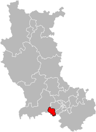
The canton of Saint-Chamond-Nord is a French former administrative division located in the department of Loire and the Rhône-Alpes region. It was disbanded following the French canton reorganisation which came into effect in March 2015. It consisted of part of the commune of Saint-Chamond, which joined the new canton of Saint-Chamond in 2015. It had 17,001 inhabitants (2012).

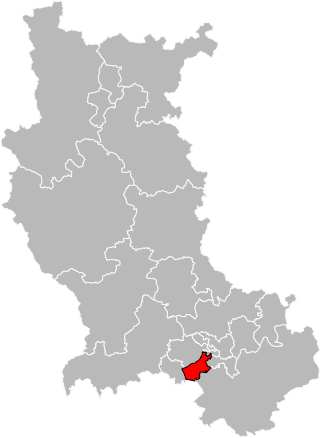
The canton of Rive-de-Gier is a French administrative division located in the department of Loire and the Auvergne-Rhône-Alpes region. At the French canton reorganisation which came into effect in March 2015, the canton was expanded from 10 to 11 communes:

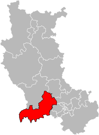
The canton of Le Pilat is a French administrative division located in the department of Loire and the Auvergne-Rhône-Alpes region. At the French canton reorganisation which came into effect in March 2015, the canton was renamed and expanded from 14 to 35 communes:

The canton of Saint-Étienne-5 is a French administrative division located in the department of Loire and the Auvergne-Rhône-Alpes region. It has the following communes:
The canton of Firminy is a French administrative division located in the department of Loire and the Auvergne-Rhône-Alpes region. It includes the following communes:

The canton of Saint-Étienne-4 is a French administrative division located in the department of Loire and the Auvergne-Rhône-Alpes region. It has the following communes:

The canton of Saint-Étienne-3 is a French administrative division located in the department of Loire and the Auvergne-Rhône-Alpes region. It has the following communes:

The canton of Boën-sur-Lignon is a French administrative division located in the department of Loire and the Auvergne-Rhône-Alpes region. At the French canton reorganisation which came into effect in March 2015, the canton was expanded from 18 to 55 communes :

The canton of Feurs is a French administrative division located in the department of Loire and the Auvergne-Rhône-Alpes region. At the French canton reorganisation which came into effect in March 2015, the canton was expanded from 23 to 33 communes:

The canton of Montbrison is a French administrative division located in the department of Loire and the Auvergne-Rhône-Alpes region. At the French canton reorganisation which came into effect in March 2015, the canton was expanded from 19 to 31 communes:
The canton of Saint-Just-Saint-Rambert is a French administrative division located in the department of Loire and the Auvergne-Rhône-Alpes region. At the French canton reorganisation which came into effect in March 2015, the canton was expanded from 12 to 18 communes:

The canton of Saint-Étienne-1 is an administrative division of the Loire department, in eastern France. It was created at the French canton reorganisation which came into effect in March 2015. Its seat is in Saint-Étienne.
The canton of Saint-Étienne-2 is an administrative division of the Loire department, in eastern France. It was created at the French canton reorganisation which came into effect in March 2015. Its seat is in Saint-Étienne.
The canton of Saint-Étienne-6 is an administrative division of the Loire department, in eastern France. It was created at the French canton reorganisation which came into effect in March 2015. Its seat is in Saint-Étienne.

The canton of Andrézieux-Bouthéon is an administrative division of the Loire department, in eastern France. It was created at the French canton reorganisation which came into effect in March 2015. Its seat is in Andrézieux-Bouthéon.

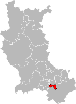
The canton of Sorbiers is an administrative division of the Loire department, in eastern France. It was created at the French canton reorganisation which came into effect in March 2015. Its seat is in Sorbiers.
The canton of Doué-en-Anjou is an administrative division of the Maine-et-Loire department, in western France. It was created at the French canton reorganisation which came into effect in March 2015. Its seat is in Doué-en-Anjou.
The canton of Plateau du Haut-Velay granitique is an administrative division of the Haute-Loire department, south-central France. It was created at the French canton reorganisation which came into effect in March 2015. Its seat is in Craponne-sur-Arzon.
