The Canton of Beuzeville is a canton of the département of Eure, in France. At the French canton reorganisation which came into effect in March 2015, the canton was expanded from 16 to 62 communes :
The arrondissement of Les Andelys is an arrondissement of France in the Eure department in the Normandy region. It has 185 communes. Its population is 235,732 (2016), and its area is 1,854.4 km2 (716.0 sq mi).

The arrondissement of Bernay is an arrondissement of France in the Eure department in the Normandy region. It has 297 communes. Its population is 227,054 (2016), and its area is 3,226.7 km2 (1,245.8 sq mi).

The arrondissement of Dieppe is an arrondissement of France in the Seine-Maritime department in the Normandy région. It has 343 communes. Its population is 237,203 (2016), and its area is 3,120.3 km2 (1,204.8 sq mi).

The Arrondissement of Rouen is an arrondissement of France in the Seine-Maritime department in the Normandy region. It has 216 communes. Its population is 631,032 (2016), and its area is 1,936.1 km2 (747.5 sq mi).
The following is a list of the 35 cantons of the Seine-Maritime department, in France, following the French canton reorganisation which came into effect in March 2015:
La Rue-Saint-Pierre is a commune in the Seine-Maritime department in the Normandy region in northern France. It belongs to the Arrondissement of Rouen and the Canton of Le Mesnil-Esnard. The inhabitants are called Bocassiens.

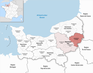
The Canton of Eu is a canton situated in the Seine-Maritime département and in the Normandy region of northern France.

The Canton of Gournay-en-Bray is a canton situated in the Seine-Maritime département and in the Normandy region of northern France.
The Canton of Longueville-sur-Scie is a former canton situated in the Seine-Maritime département and in the Haute-Normandie region of northern France. It was disbanded following the French canton reorganisation which came into effect in March 2015. It consisted of 23 communes, which joined the canton of Luneray in 2015. It had a total of 8,022 inhabitants (2012).

The Canton of Neufchâtel-en-Bray is a canton situated in the Seine-Maritime département and in the Normandy region of north-western France.

The Canton of Saint-Valery-en-Caux is a canton situated in the Seine-Maritime département and in the Normandy region of northern France.

The Canton of Bois-Guillaume is a canton situated in the Seine-Maritime département and in the Normandy region of northern France. It covers northern suburbs of Rouen, including the town of Bois-Guillaume, and the rural area north of Rouen.
The Canton of Boos is a former canton situated in the Seine-Maritime département and in the Haute-Normandie region of northern France. It was disbanded following the French canton reorganisation which came into effect in March 2015. It had a total of 38,802 inhabitants (2012).
The Canton of Buchy is a former canton situated in the Seine-Maritime département and in the Haute-Normandie region of northern France. It was disbanded following the French canton reorganisation which came into effect in March 2015. It consisted of 21 communes, which joined the canton of Le Mesnil-Esnard in 2015. It had a total of 10,781 inhabitants (2012).
The Canton of Clères is a former canton situated in the Seine-Maritime département and in the Haute-Normandie region of northern France. It was disbanded following the French canton reorganisation which came into effect in March 2015. It had a total of 22,992 inhabitants (2012).

The Canton of Yvetot is a canton situated in the Seine-Maritime département and in the Normandy region of northern France.

Métropole Rouen Normandie is the métropole, an intercommunal structure, centred on the city of Rouen. It is located in the Seine-Maritime department, in the Normandy region, north-western France. It was created in January 2015, replacing the previous Communauté d'agglomération Rouen-Elbeuf-Austreberthe. Its area is 663.8 km2. Its population was 492,681 in 2014, of which 111,360 in Rouen proper.

The canton of Luneray is an administrative division of the Seine-Maritime department, in northern France. It was created at the French canton reorganisation which came into effect in March 2015. Its seat is in Luneray.
Communauté d'agglomération Seine-Eure is an intercommunal structure, centred on the city of Louviers. It is located in the Eure department, in the Normandy region, northern France. It was created in September 2019. Its seat is in Louviers. Its population was 103,496 in 2017, of which 18,648 in Louviers proper.
