The arrondissement of Rodez is an arrondissement of France in the Aveyron department in the Occitanie region. Since the January 2017 reorganization of the arrondissements of Aveyron, it has 79 communes.
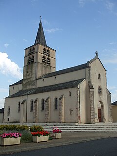
Baraqueville is a commune in the Aveyron department in the Occitanie region of southern France.
Luc-la-Primaube is a commune in the Aveyron department in southern France, in Occitanie. It is located at ten kilometres south of Rodez. Its inhabitants are called Lucois or Primaubois. Indeed, the commune includes two towns: Luc and La Primaube, 3 km (1.9 mi) apart.
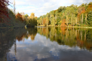
Étang de la Brienne is a lake of Luc-la-Primaube in Aveyron, France. At an elevation of 640 m, its surface area is 0.105 km².

Luc-Primaube is a railway station in Luc-la-Primaube, Occitanie, France. The station opened in 1902 and is located on the Castelnaudary - Rodez railway line. The station is served by TER (local) services operated by SNCF.
The canton of Aveyron-Lère is an administrative division of the Tarn-et-Garonne department, in southern France. It was created at the French canton reorganisation which came into effect in March 2015. Its seat is in Caussade.
The canton of Villefranche-de-Rouergue is an administrative division of the Aveyron department, southern France. Its borders were modified at the French canton reorganisation which came into effect in March 2015. Its seat is in Villefranche-de-Rouergue.
The canton of Aubrac et Carladez is an administrative division of the Aveyron department, southern France. It was created at the French canton reorganisation which came into effect in March 2015. Its seat is in Laguiole.
The canton of Aveyron et Tarn is an administrative division of the Aveyron department, southern France. It was created at the French canton reorganisation which came into effect in March 2015. Its seat is in Rieupeyroux.
The canton of Lot et Palanges is an administrative division of the Aveyron department, southern France. It was created at the French canton reorganisation which came into effect in March 2015. Its seat is in Saint-Geniez-d'Olt-et-d'Aubrac.
The canton of Tarn et Causses is an administrative division of the Aveyron department, southern France. It was created at the French canton reorganisation which came into effect in March 2015. Its seat is in Sévérac-d'Aveyron.
The canton of Vallon is an administrative division of the Aveyron department, southern France. It was created at the French canton reorganisation which came into effect in March 2015. Its seat is in Salles-la-Source.
The canton of Causse-Comtal is an administrative division of the Aveyron department, southern France. It was created at the French canton reorganisation which came into effect in March 2015. Its seat is in Sébazac-Concourès.
The canton of Causses-Rougiers is an administrative division of the Aveyron department, southern France. It was created at the French canton reorganisation which came into effect in March 2015. Its seat is in La Cavalerie.
The canton of Enne et Alzou is an administrative division of the Aveyron department, southern France. It was created at the French canton reorganisation which came into effect in March 2015. Its seat is in Aubin.
The canton of Lot et Truyère is an administrative division of the Aveyron department, southern France. It was created at the French canton reorganisation which came into effect in March 2015. Its seat is in Espalion.
The canton of Rodez-2 is an administrative division of the Aveyron department, southern France. It was created at the French canton reorganisation which came into effect in March 2015. Its seat is in Rodez.
The canton of Rodez-Onet is an administrative division of the Aveyron department, southern France. It was created at the French canton reorganisation which came into effect in March 2015. Its seat is in Rodez.
The canton of Monts du Réquistanais is an administrative division of the Aveyron department, southern France. It was created at the French canton reorganisation which came into effect in March 2015. Its seat is in Réquista.
The canton of Villeneuvois et Villefranchois is an administrative division of the Aveyron department, southern France. It was created at the French canton reorganisation which came into effect in March 2015. Its seat is in Villeneuve.

