The arrondissement of Millau is an arrondissement of France in the Aveyron department in the Occitanie region. Since the January 2017 reorganization of the arrondissements of Aveyron, it has 110 communes.
The arrondissement of Rodez is an arrondissement of France in the Aveyron department in the Occitanie region. Since the January 2017 reorganization of the arrondissements of Aveyron, it has 79 communes.
The following is a list of the 23 cantons of the Aveyron department, in France, following the French canton reorganisation which came into effect in March 2015:
Arques is a commune in the Aveyron department in the Occitanie region of southern France.
Arvieu is a commune in the Aveyron department in the Occitanie region of southern France.

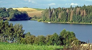
Lac de Pareloup is a lake in Aveyron, France. It lies on the Lévézou plateau, 25 km south east of Rodez.
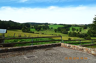
The Lévézou is a geographical region in the Aveyron department in southern France. It is an impervious crystalline plateau with an average altitude of around 900m. Its highest point is Mont Seigne. Though its borders are not strictly defined, it is bounded in the south and east by the River Tarn and to the north by the Viaur. To the west it merges into the Ségala.
The canton of Aubrac et Carladez is an administrative division of the Aveyron department, southern France. It was created at the French canton reorganisation which came into effect in March 2015. Its seat is in Laguiole.
The canton of Aveyron et Tarn is an administrative division of the Aveyron department, southern France. It was created at the French canton reorganisation which came into effect in March 2015. Its seat is in Rieupeyroux.
The canton of Lot et Dourdou is an administrative division of the Aveyron department, southern France. It was created at the French canton reorganisation which came into effect in March 2015. Its seat is in Decazeville.
The canton of Lot et Palanges is an administrative division of the Aveyron department, southern France. It was created at the French canton reorganisation which came into effect in March 2015. Its seat is in Saint-Geniez-d'Olt-et-d'Aubrac.
The canton of Tarn et Causses is an administrative division of the Aveyron department, southern France. It was created at the French canton reorganisation which came into effect in March 2015. Its seat is in Sévérac-d'Aveyron.
The canton of Causses-Rougiers is an administrative division of the Aveyron department, southern France. It was created at the French canton reorganisation which came into effect in March 2015. Its seat is in La Cavalerie.
The canton of Ceor-Ségala is an administrative division of the Aveyron department, southern France. It was created at the French canton reorganisation which came into effect in March 2015. Its seat is in Baraqueville.
The canton of Enne et Alzou is an administrative division of the Aveyron department, southern France. It was created at the French canton reorganisation which came into effect in March 2015. Its seat is in Aubin.
The canton of Lot et Truyère is an administrative division of the Aveyron department, southern France. It was created at the French canton reorganisation which came into effect in March 2015. Its seat is in Espalion.
The canton of Nord-Lévezou is an administrative division of the Aveyron department, southern France. It was created at the French canton reorganisation which came into effect in March 2015. Its seat is in Luc-la-Primaube.
The canton of Villeneuvois et Villefranchois is an administrative division of the Aveyron department, southern France. It was created at the French canton reorganisation which came into effect in March 2015. Its seat is in Villeneuve.
The canton of Chartreuse-Guiers is an administrative division of the Isère department, eastern France. It was created at the French canton reorganisation which came into effect in March 2015. Its seat is in Saint-Laurent-du-Pont.

