
Seaton Glacier is a glacier 17 miles (27 km) long, flowing southeast into Edward VIII Ice Shelf at the northwest part of Edward VIII Bay. It was mapped by Norwegian cartographers from aerial photos taken by the Lars Christensen Expedition, 1936–37, remapped, 1954–58, by ANARE and named by ANCA in 1958 for Flight Lt. John Seaton, RAAF, pilot with ANARE at Mawson in 1956.

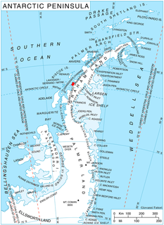
The Fallières Coast is that portion of the west coast of the Antarctic Peninsula between the head of Bourgeois Fjord and Cape Jeremy and lies on Marguerite Bay and the Wordie Ice Shelf. On the south it is joined by Rymill Coast, and in the north by Loubet Coast. Fallières Coast was first explored in January 1909 by the French Antarctic Expedition under J.B. Charcot, who named it for Armand Fallières, then President of France.
Hanusse Bay is a broad bay, 37 kilometres (20 nmi) long in a general north-south direction, lying between the northern portions of Adelaide Island and Arrowsmith Peninsula, Antarctica. The bay was discovered and first charted by the French Antarctic Expedition, 1908–10, under Jean-Baptiste Charcot, and named by him for the director of the Hydrographic Service of the French Navy Ferdinand Isidore Hanusse (1848–1921).
Decazes Island is an island 0.8 km (0.5 mi) long, lying 2.4 km (1.5 mi) southwest of Belding Island at the southwestern extremity of the Biscoe Islands. The island is one of the largest of many small islets and rocks that fringe the northern side of Matha Strait. The vicinity was charted by the French Antarctic Expedition, 1908–10, under Jean-Baptiste Charcot, who applied the name "Pointe Decazes" to the south end of an island in this approximate position. The original application has been altered in recent years, and the name Decazes is now established in usage for the entire island described.

Posadowsky Glacier is a glacier about 9 nautical miles long, flowing north to Posadowsky Bay immediately east of Gaussberg. Posadowsky Bay is an open embayment, located just east of the West Ice Shelf and fronting on the Davis Sea in Kaiser Wilhelm II Land. Kaiser Wilhelm II Land is the part of East Antarctica lying between Cape Penck, at 87°43'E, and Cape Filchner, at 91°54'E, and is claimed by Australia as part of the Australian Antarctic Territory. Other notable geographic features in this area include Drygalski Island, located 45 mi NNE of Cape Filchner in the Davis Sea, and Mirny Station, a Russian scientific research station.
Barber Glacier is a glacier rising just east of Mount Bruce in the Bowers Mountains and flowing north to the coast between Stuhlinger Ice Piedmont and Rosenau Head, Victoria Land, Antarctica. The glacier was mapped by the United States Geological Survey from surveys and from U.S. Navy air photos, 1960–65, and named by the Advisory Committee on Antarctic Names for Captain Don W. Barber, CE, USA, construction and equipment officer, U.S. Naval Support Force, Antarctica, 1967 and 1968. The glacier lies on the Pennell Coast, a portion of Antarctica lying between Cape Williams and Cape Adare.
Beascochea Bay is a bay, 10 nautical miles (19 km) long and 5 nautical miles (9 km) wide, indenting the Graham Coast of Graham Land, Antarctica, between Kiev Peninsula and Barison Peninsula, and entered south of Cape Perez. The glaciers Lever, Funk, Cadman, Talev and Butamya feed the bay.
The Bragg Islands are a small group of islands in Crystal Sound, about 7 nautical miles (13 km) north of Cape Rey, Graham Land. They were mapped from surveys by the Falkland Islands Dependencies Survey (1958–59) and from air photos obtained by the Ronne Antarctic Research Expedition (1947–48). The group was named by the UK Antarctic Place-Names Committee for Sir William H. Bragg, an English physicist who interpreted X-ray measurements to give the location of oxygen atoms in the structure of ice.
Cézembre Point is a rocky point 0.5 nautical miles (1 km) northeast of Cape Margerie. It was charted in 1950 by the French Antarctic Expedition and named for Cézembre, an island in the Golfe de Saint-Malo, France.
Mount Chadwick is a small, bare rock mountain, 2,440 metres (8,000 ft) high, situated 2.5 nautical miles (5 km) east-southeast of Mount Walton in the Outback Nunataks, Victoria Land, Antarctica. The topographical feature was first mapped by the United States Geological Survey from surveys and from U.S. Navy air photos, 1959–64, and named by the Advisory Committee on Antarctic Names for Dan M. Chadwick, meteorologist at the South Pole Station, 1968. The mountain lies situated on the Pennell Coast, a portion of Antarctica lying between Cape Williams and Cape Adare.

Commandant Charcot Glacier is a prominent glacier about 3 nautical miles (6 km) wide and 12 nautical miles (22 km) long, flowing north-northwest from the continental ice to its terminus at the head of Victor Bay. It was delineated from aerial photographs taken by U.S. Navy Operation Highjump, 1946–47. The French Antarctic Expedition, 1950–1952, under Mario Marret sledged west along the coast to Victor Bay, close east of this glacier, in December 1952, and it was named by them for the polar ship Commandant Charcot which transported French expeditions to this area, 1948–1952.

Darbel Bay is a bay 25 nautical miles (50 km) wide, indenting the west coast of Graham Land between Stresher Peninsula and Pernik Peninsula. Entered southwest of Cape Bellue and northeast of Cape Rey. The glaciers Widmark Ice Piedmont, Cardell, Erskine, Hopkins, Drummond, Widdowson, McCance, Solun and Škorpil feed the bay.
Delay Point is a rocky bluff rising to 185 metres (600 ft) on the west side of Melba Peninsula, about 6 nautical miles (11 km) west of Cape Charcot. It was discovered by the Australasian Antarctic Expedition under Mawson, 1911–14, and so named by the Eastern Sledge Party of the Western Base because bad weather delayed the party near here for several days in November 1912.
Cape Evensen is a cape forming the north side of the entrance to Auvert Bay, on the northwest coast of Stresher Peninsula, Graham Land in Antarctica. It was discovered by the French Antarctic Expedition, 1903–05, and named by Jean-Baptiste Charcot for Captain C.J. Evensen of the Hertha, who explored along the west coast of the Antarctic Peninsula in 1893.
Marret Glacier is a channel glacier about 4 nautical miles (7 km) wide and 4 nautical miles long, flowing northeast from the continental ice of Antarctica to the coast close east of Cape Robert. It was delineated from aerial photos taken by U.S. Navy Operation Highjump, 1946–47, and was named by the Advisory Committee on Antarctic Names for Mario Marret, the leader of the French Antarctic Expedition, 1952–53, whose party extended reconnaissance of the coastal features to the west side of Victor Bay.
Matha Strait is a strait lying between Adelaide Island and the south end of the Biscoe Islands. The strait takes its name from "Matha Bay", the name originally applied by Jean-Baptiste Charcot, leader of the French Antarctic Expedition, 1908–10, to the water feature as he conceived it. The British Graham Land Expedition under John Rymill, 1934–37, recognizing that it is really a strait rather than a bay, changed the name to Matha Strait. The name is for Lieutenant André Matha, second-in-command of the French Antarctic Expedition, 1903–05, also under Charcot.

May Glacier is a channel glacier about 5 nautical miles (9 km) wide and 6 nautical miles (11 km) long, flowing to the coast of Antarctica between Cape Morse and Cape Carr. It was delineated from air photos taken by U.S. Navy Operation Highjump (1946–47), and was named by the Advisory Committee on Antarctic Names for William May, passed midshipman on the Flying Fish of the United States Exploring Expedition (1838–42) under Charles Wilkes.
Marie Island is an island 2 nautical miles (4 km) long, which lies immediately north of Cape Evensen on the northwest coast of Stresher Peninsula in Graham Land, Antarctica. The name "Pointe Marie," after the elder sister of Dr. Jean-Baptiste Charcot, was applied by the Third French Antarctic Expedition (1903–05) to a point on the coast close north of Cape Evensen. After the Fourth French Antarctic Expedition (1908–10) Charcot re-applied the name to the southern tip of an island, "Ile Waldeck-Rousseau," in approximately the same latitude. Correlating its survey with those of Charcot, the British Graham Land Expedition (1934–37) identified "Ile Waldeck-Rousseau" as Waldeck-Rousseau Peak on the mainland. The most prominent feature near the peak requiring a name is this island, and the name "Marie Island" preserves Charcot's naming in the locality.
Cape Keltie is an ice-covered cape on the Clarie Coast of Antarctica, 11 nautical miles (20 km) west of Cape Cesney. It was discovered from the Aurora by the Australasian Antarctic Expedition (1911–14) under Douglas Mawson, and roughly charted at a distance of about 10 nautical miles (19 km) as lying in 66°5′S 133°0′E. It was named by Mawson for Sir John Scott Keltie, Secretary of the Royal Geographical Society, 1892–1915. The identification of this feature is based upon the G.D. Blodgett map of 1955, compiled from aerial photos taken by U.S. Navy Operation Highjump (1946–47).
Cape Leblond is a cape forming the northern end of Lavoisier Island, in the Biscoe Islands of Antarctica. It was mapped by the French Antarctic Expedition, 1908–10, under Jean-Baptiste Charcot, and named by him for the President of the Norman Geographical Society at Rouen.

